Davies Plain Track - 2.3 km track section currently closed due to flood damage
A 2.3km section of
Davies Plain Track, near Davies Plain Hut Camping Area within the Alpine
National Park, is currently closed to all vehicles because of significant water
damage and severe erosion, following recent flood and storm events in the area. As
a result of the temporary closure, Davies Plain Track is not a
thoroughfare for vehicles between Tom Groggin and Charlies Creek Camping
Area. There is currently no vehicle access to Davies Plain Hut or the
adjoining camping area, pending further assessments
and subsequent repairs. Nearest camping areas accessible to
suitable 4WD vehicles on Davies Plain Track are Charlies Creek Camping Area to
the south; and Buckwong Creek Camping Area to the north (near Tom
Groggin).
Attachments:
Flood damaged track section currently closed to all vehicles Davies Plain south (189KB)
Eastern Alps track closures due to storm and flood damage
The 4x4 tracks in the Eastern Region are an iconic part of Victoria and an important focal point for many people. With a large number of visits per year, they are very popular for outdoor activities such as camping, hiking, mountain biking and four-wheel driving.
Unfortunately, sometimes we must close infrastructure in the interests of public safety and environmental protection.
The following tracks have been significantly damaged by storms and floods and are currently closed to motor vehicles to ensure public safety and environmental protection:
- Cobberas Track
-
Macfarlane Flat Track
-
Ingeegoodbee Track
The tracks are likely to remain closed to motor vehicles until detailed site assessments have been completed. Assessments and repair works are not expected to be completed until late 2024 / early 2025.
Before visiting, Visitors should always check the Parks Victoria website for the latest information about their desti
nation.
Wobonga Track Closure
Wobonga Track is CLOSED due to upgrade works being completed. This closure will be in effect until the 30th of April.
- Alternative access to King Basin Track is via Basin Track and Long Spur Track.
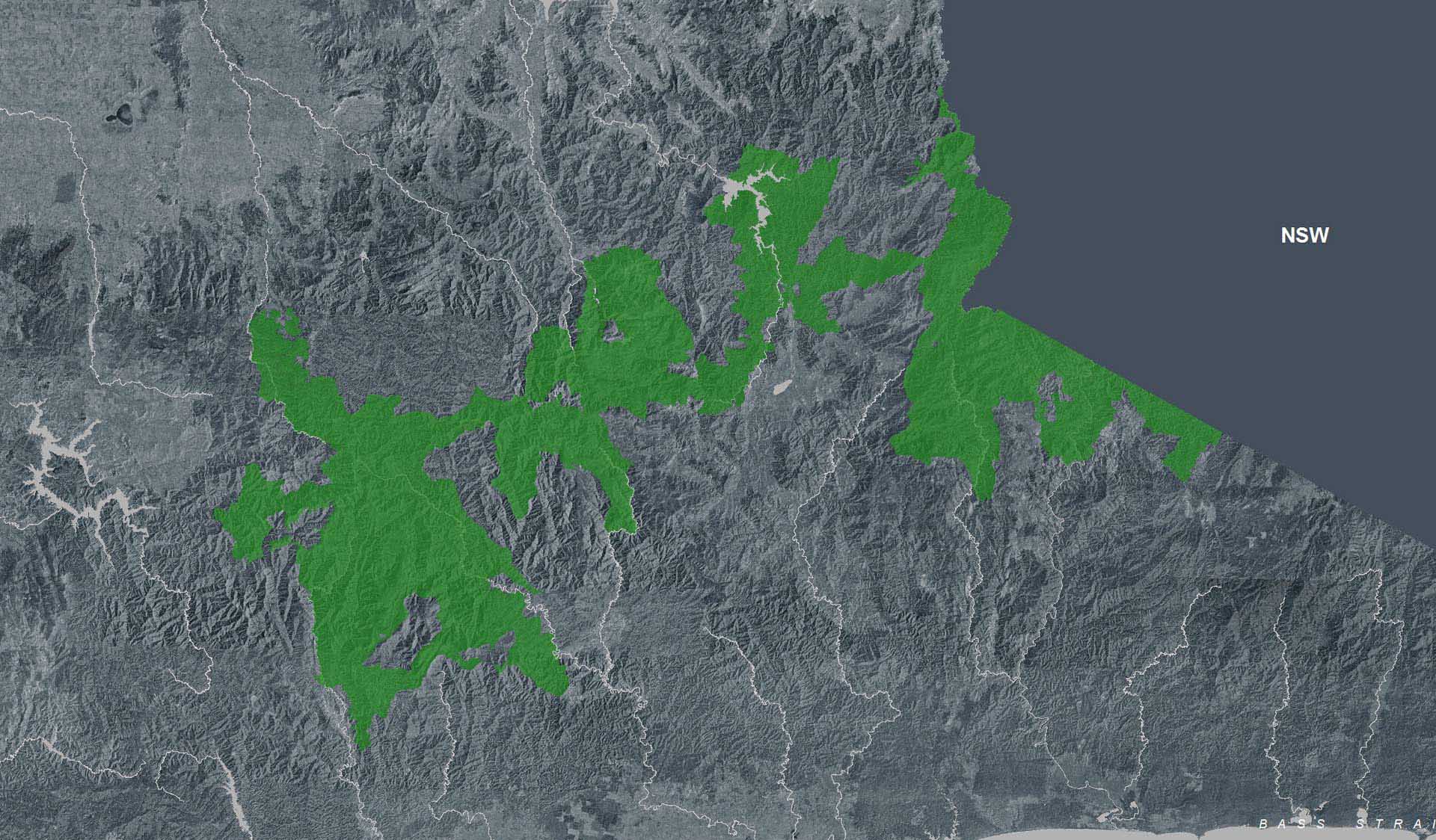
Planned aerial shooting operations targeting deer - Alpine National Park
Parts of the Alpine National Park will be closed while aerial
shooting operations targeting deer are undertaken (See
attached map for details).
The closures will apply during the following dates:
29 April – 2 May 2024 (Bogong High Plains)
29 April – 3 May 2024 (Feathertop and Dinner Plain/Dargo High Plains)
The following
tracks and visitor areas will be open during the operation:
OPEN – MT FEATHERTOP AREA
· Bungalow Spur
· The Razorback
· Diamantina Spur
· Mt Feathertop
· Federation Hut
· West Kiewa Logging Road
· Blairs Hut
OPEN – MT HOTHAM/DINNER PLAIN AREA
· Great Alpine Road
· Dargo High Plains Road
· Dinner Plain Track
· Blue Rag Range Track
· Machinery Spur
· Swindlers Spur
· Dibbins Hut
· Brabralung Trail
· Carmichael Falls
· Dead Timber Hill Walking Track
· Room with a View Walking Track
OPEN – BOGONG HIGH PLAINS AREA
· Bogong High Plains Road
· Pretty Valley Road
· Wallace Hut
· Pretty Valley Hut
· Pretty Valley Camping Area
· Mountain Creek Camping Area
· Big River Camping Area
For more information about the program and park closures, please visit
this link.
Attachments:
Alpine National Park aerial operations information April_May 2024 (9,883KB)
Moroka River Pedestrian Bridge CLOSED until further notice
The Moroka River pedestrian bridge is closed until further notice due to being assessed as structurally unsound.
Access to Moroka Hut is via the Moroka Range Walking Track (4WD only).
Bogong High Plains Road
Following the landslide at Bogong Village the Bogong High Plains Road is now open however remediation work will
continue into the foreseeable future to rectify the damage created by the
landslide. Parks Victoria advises that all visitors check the Regional Roads Victoria and Victoria's big build website
for the latest traffic updates on closures or delays before visiting.
https://regionalroads.vic.gov.au/map/north-eastern-improvements/bogong-high-plains-road-landslip
https://bigbuild.vic.gov.au/projects/mrpv/bogong-high-plains-road-landslip
Ambyne Settlement Road - Very Poor Condition, Limited Access to Alpine National Park east of the Snowy River
Ambyne Settlement Road passes through private property and links Ambyne Road with Ambyne Track, Amboyne Boundary Track and Blackguard Gully Track. This road provides one of the few access routes into and out of the Alpine National Park on the eastern side of the Snowy River.
Recent severe storms caused local flash flooding in the Ambyne Valley and have resulted in parts of Ambyne Settlement Road becoming severely damaged with washed out creek crossings in several areas.
Visitors need to be advised that access into and out of the Alpine National Park via Ambyne Settlement Road is currently very difficult and should only be attempted by experienced drivers with high clearance 4WDs and recovery equipment.
There are no alternate, publicly accessible routes nearby which provide access through the private property in the Ambyne Valley.
Attachments:
Map - Ambyne Settlement Rd - Very Poor Condition (1,400KB)
Restricted Access at Eastern end of Spring Saddle Track
The eastern end of Spring Saddle Track has restricted access due to machinery continuing to clear soil as part of the Bogong Village landslip remediation works. The track is open to pedestrian traffic but not vehicles and no Park visitors will be able to enter the works site at the Eastern end of Spring Saddle Track. There is signage explaining the restrictions at the Spring Saddle Track Fainter Fire Trail intersections.
Storm Damage to Dry River Walking Track
Dry River Walking Track has been impacted by storm events and is in poor condition and difficult to navigate with horses. Alternative tracks should be considered.
Mt Pinnibar Track - poor track conditions
Mt Pinnibar Track, between Walkers Road and Tom Groggin Track, has developed sections of significant and deep track erosion following flood and storm events.
While the track remains open it is recommended that only experienced drivers in well equipped 4WD vehicles attempt this track in dry conditions.
All visitors are advised to consider alternate routes to the summit of Mt Pinnibar until repairs can be carried out.
Ground shooting operations targeting deer
Control operations (ground shooting) targeting
deer are undertaken in this area. The
Park will remain open to visitors during operations.
For more information about deer control to
protect biodiversity, please visit this link.
Ground shooting operations targeting Feral Pigs Eastern Alps from 15 April 2024.
Ground operations (ground shooting) targeting Feral Pigs are undertaken across the Eastern Alps, and include areas to the west and north of Suggan Buggan, west of Wulgulmerang, and east of Cobberas and Brumby. The Park will remain open to visitors during operations.This work is to be carried out dusk to dawn from:* 15 to 26 April, and* 29 May to 15 June 2024.
Attachments:
Flyer for feral pig control FINAL (165KB)
Road Conditions – Tamboritha and Howitt Roads
Tamboritha and Howitt Roads in the Foothills and Southern Alps area of the Alpine National Park are currently recommended for all wheel drive and four wheel drive vehicles with sufficient clearance and appropriate tyres. Road maintenance works have been completed on sections the Tamboritha and Howitt Roads in summer 2024, however some road surfaces conditions remain poor.
Vehicles travelling on the these roads require attention to variations of the surface condition.
Allow more time for your journey and always drive to the conditions.