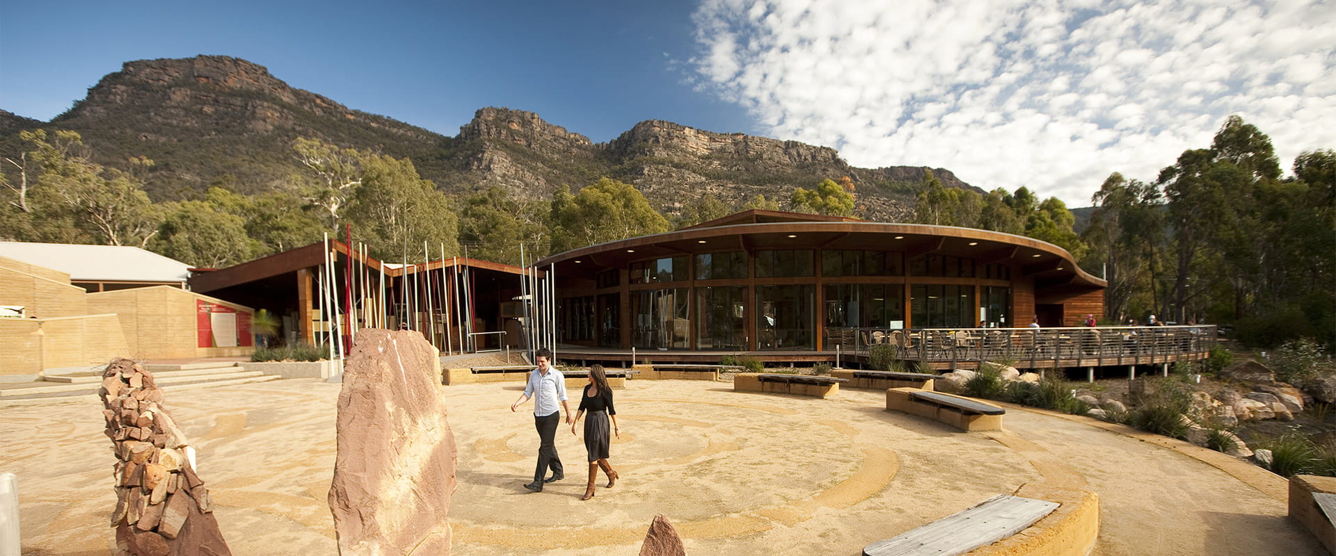

Brambuk: The National Park and Cultural Centre, in Halls Gap began, with the building of the Brambuk Cultural Centre in 1989 to acknowledge, protect and share the cultures of the Jadawadjali and Djab Wurrung Peoples.
![]()
![]()
![]()
277 Grampians Road
Halls Gap VIC 3381
View map brambuk@parks.vic.gov.au
Make Brambuk the National Park and Cultural Centre in Halls Gap your first stop before exploring Grampians (Gariwerd) National Park.
Visit the National Park Information Centre where you can source the latest park information including walking, camping and touring. Knowledgeable park staff can help you discover famous hiking trails, beautiful waterfalls, spectacular mountain views and ancient Aboriginal rock art shelters. A unique range of local Indigenous products, Australian made souvenirs and park maps are available in the gift shop to help you enjoy your stay.
A series of self-guided and wheelchair friendly walks through the Brambuk wetlands and native gardens links the Park Information Centre to the Cultural Centre, and provides a glimpse of the native plants and animals of Gariwerd.
Since opening in 1990, Brambuk provides an opportunity for visitors to connect and learn about what Gariwerd means to the Jadawadjali and Djab Wurrung people. The award-winning Cultural Centre building is currently closed for upgrades, and these works are expected to be ongoing between 2022 and 2024.
Keep an eye on the Parks Victoria Junior Ranger website for the latest list of holiday activities and programs.
Brambuk is 2kms south of Halls Gap and is open 7 days a week (except Christmas Day) from 9am-4pm or phone 8427 2058.
How to get there
Brambuk The National Park and Cultural Centre
Facilities
Need to know
Brambuk The National Park and Cultural Centre
Accessibility
Visiting a park can be more of a challenge for people with disabilities, however in Victoria there are a wide range of facilities to help people of all abilities enjoy our wonderful parks around the state. Visit our All abilities access page to find more.
A Trailrider all-terrain wheelchair and Sherpa Volunteers are now available for park visitors with limited mobility to explore the natural beauty of Grampians National Park. The Grampians has two TrailRiders available for visitors and both of these chairs are fitted with electric motors to assist operators on steeper sections of track. Passengers must wear a helmet.
The TrailRider all-terrain wheelchair and Volunteer Sherpa service is free of charge, however, please book a week in advance. To book the TrailRider please contact the Volunteer Sherpa Coordinator on (03) 8427 3541 or volunteersherpa@parks.vic.gov.au
Change of Conditions
Nature being nature, sometimes conditions can change at short notice. It’s a good idea to check this page ahead of your visit for any updates.
-
Grampians National Park
Mountain Lion (Designated rock-climbing and bouldering area) – Temporary exclusion
Mountain Lion (Designated rock-climbing and bouldering area) – Temporary exclusionSignificant Aboriginal cultural values have recently been rediscovered at the Mountain Lion designated rock-climbing and bouldering area.While Parks Victoria and Gariwerd Traditional Owners determine a longer-term management response, and out of respect for this significant cultural landscape, visitors are requested to not access this area.The Aboriginal Heritage Act 2006 protects Aboriginal cultural heritage and significant financial penalties apply for harm caused by individuals or corporate bodies.For more information please visit the FAQ Update at the Rock Climbing in Gariwerd link below.Temporary Closure Notification – Planned Burn – Oslers Track
FFMVIC have scheduled ignition for the following Planned Burn within Grampians (Gariwerd) National Park
Oslers Track (GR-WIM-HGP-0042)
Start Date: Wednesday 17 April until advisedForest Fire Management Victoria advise that the planned burn will be carried out, weather and fuel moisture conditions permitting.
Burn Name: Oslers TrackTemporary closures:Oslers TrackOslers Track Bush CampsVisit & Sign Up: Sign up to Planned Burns Victoria www.vic.gov.au/plannedburns Set up automated notifications about upcoming planned burns on public land near you. There is no charge to sign up to receive text messages.
Download: The Vic Emergency App. Set up a watch zone and choose to be notified about planned burns in the ‘alerts’ settingsCall: The Vic Emergency Hotline on 1800 226 226 and request an interpreter or assistance for hearing difficulties via the National Relay Service. IN AN EMERGENCY CALL 000Email: For specialist advice about planned burns in the Wimmera District you can contact Horsham FFMVic Office at wimmera.fuelmanagement@delwp.vic.gov.au or phone the office on (03) 8508 1222.
For Information about park closures and campground bookings within Grampians National Park:Visit the Parks Victoria website: https://www.parks.vic.gov.au/places-to-see/parks/grampians-national-park#change-of-conditionsVisit Brambuk the National Park and Cultural Centre – 277 Grampians Road Halls Gap, Ph 8427 2058 or for bookings and cancellations advice contact the Parks Victoria Information Centre Ph 13 1963 or email info@parks.vic.gov.auYou may see or smell smoke in the vicinity of the burn. For advice on how this may impact your health, visit www.epa.vic.gov.au/smokeGrampians (Gariwerd) National Park - Roads Update 22.04.2024
The Grampians (Gariwerd) National Park has several roads temporarily closed for repair works, upgrades, and recent fire impacts. Please be aware the movement of visitors in these parts of the National Park is restrictedPlanned Burn Road ClosuresMillstream CreekScheduled 21/04/204-23/04/24Mt Difficult Rd (from Mt Victory Rd to the East Wartook track intersection)Old Mill Rd from (Wartook Road to Boroka Lookout)Rose Creek Rd (north from Mt Victory Rd)Wartook East TrackCassidy GapScheduled 22/04/2024-24/04/2024Mann’s Road - closed east of the intersection with Victoria Valley RdSerra Range Fireline - closed at the intersection of Vic Valley Road and Cassidy Gap RoadCassidy Gap Rd closed from its intersection with Serra Range Fireline to its intersection with Grampians Rd.Road Closures
Mitchell Road is closed between Redman Road and Mt William Picnic Ground Road.Seasonal Closures
Launders and Sanders Tracks are closed.Moora Moora Track is partially closed in the southern section, from Homestead Track intersection to Glenelg River Road.Grampians Peaks Trail – Trailhead Access
Road access (Griffin Track) to the Griffin Trailhead for the Grampians Peaks Trail is open to 4WD vehicles only. Walkers can access the GPT on foot via the Griffin Track from the Grampians Tourist Road.Please see the latest road report attachment for full road and track details at the bottom of this page.Attachments: Grampians (Gariwerd) National Park - Road Report - 22.04.2024 (277KB)
-
Plantation Campground (Mount Difficult Plantation Campground, MT DIFFICULT STATE FOREST)
Plantation Campground Re-opened
Plantation Campground has now re-opened after completion of the Oslers Track Planned Burn. -
Notices Affecting Multiple Sites
Grampians National Park - Autumn planned burn season underway
Grampians (Gariwerd) National Park – Autumn Planned Program UnderwayForest Fire Management Victoria (FFMVic) have commenced the Autumn Planned Burning Program in Grampians (Gariwerd) National Park and surrounding reserves.These planned burns have been nominated and approved as part of the FFMVic three-year Joint Fuel Management Program for the Wimmera Fire District. Each burn has been designated to a year and season, though this may change depending on burn objectives and seasonal conditions. You can view the three-year plan at https://www.ffm.vic.gov.au/bushfire-fuel-and-risk-management/joint-fuel-management-programThe map attached, outlines the burns programmed for this year. Detailing the exact date and time of ignition can be difficult and the final decision to proceed may only be made on the day of the burn - once resources, weather conditions and local fuel moisture levels are deemed suitable. Once a burn is scheduled for ignition, FFMVIC will send out regular notifications.Some of the planned burns this Autumn may involve the temporary closure of visitor sites, roads and campgrounds within Grampians Gariwerd National Park and other reserves. This may include detours or closures of hike in campgrounds along the Grampians Peaks Trail, and other vehicle-based campgrounds.· Closures will be enforced for the duration of ignition and may remain in place for some days. Visitor sites will re-open once the burn is declared safe.· We recommend that you seek information and stay informed about the status of the planned burns scheduled near you.Stay informed about this Autumns planned burns schedule:Visit & Sign Up:Sign up to Planned Burns Victoria to set up automated notifications about upcoming planned burns on public land near you. There is no charge to sign up to receive text messages.
Sign up via Planned Burns Victoria at www.vic.gov.au/plannedburnsDownload: the VicEmergency AppSet up a watch zone and choose to be notified about planned burns in the ‘alerts’ settingsCall: the VicEmergency Hotline on 1800 226 226 and request an interpreter or assistance for hearing difficulties via the National Relay ServiceEmail: For specialist advice about planned burns in the Wimmera District you can contact Horsham FFMVic Office at wimmera.fuelmanagement@delwp.vic.gov.au or phone the office on (03) 8508 1222.For Information about park closures and campground bookings within Grampians National Park:Visit the Parks Victoria website: https://www.parks.vic.gov.au/places-to-see/parks/grampians-national-park#change-of-conditionsVisit: Brambuk the National Park and Cultural Centre – 277 Grampians Road Halls Gap, Ph 8427 2058or for bookings and cancellations advice contact the Parks Victoria Information Centre Ph 13 1963 or email info@parks.vic.gov.au