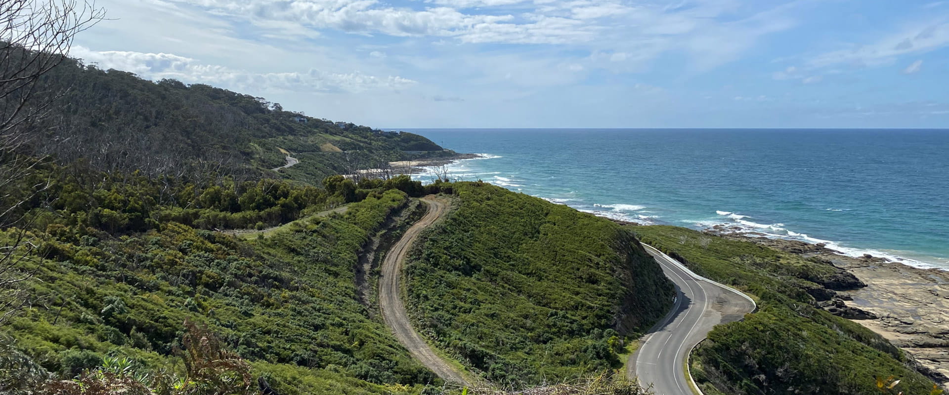
A beautiful coastal walk following the Great Ocean Road through sections of forest between Kennett River and Wye River townships. Enjoy coastal views to Cape Otway and over Bass Straight while hugging the steep edge of the Otway Ranges and treading the line between forest and ocean.
This undulating 4.6km coastal track with steps and creek crossings links the townships of Wye River and Kennett River. High points of the track offer views through tall eucalypts to the Southern Ocean beyond. Learn about the history of the area through storyboards and listen for birdlife as you walk through forest above the Great Ocean Road.
Commencing at the Wye River hotel and winding through the streets of the township, the trail begins at the top of Morely Avenue. A meandering track with some challenging steep sections, this walk follows the coastline above the Great Ocean Road before descending into Kennett River.
Kennett - Wye River is located in Great Otway National Park 15 minutes east of Lorne. The coastal and forest setting is less developed than nearby Lorne providing a quieter and more relaxed atmosphere. There are a small number of areas to camp, walk or take in the sites along the Great Ocean Road. Facilities in this area are more basic.
Changes to Great Ocean Road parks and campsites
From 1 July 2026, some parks and campsites along the Great Ocean Road will be managed by the Great Ocean Road Coast and Parks Authority (GORCAPA). Visit the GORCAPA website to see which parks GORCAPA manage.
This change is part of the transition of land management responsibilities to GORCAPA, helping support a dedicated and localised approach to managing the Great Ocean Road coast and parks.
Wildlife
How to get there
Wye to Kennett River Walk
When you're there
Download a visitor guide for the area for information and a detailed map.
Need to know
Wye to Kennett River Walk
Accessibility
Visiting a park can be more of a challenge for people with disabilities, however in Victoria there are a wide range of facilities to help people of all abilities enjoy our wonderful parks around the state.
Assistance dogs are welcome in Parks Victoria parks and reserves. Entry requirements apply for parks and reserves that are usually dog prohibited, such as national parks.
Change of Conditions
Nature being nature, sometimes conditions can change at short notice. It’s a good idea to check this page ahead of your visit for any updates.
-
Aire River West Campground (Great Otway National Park GORCAPA, Aire River Heritage River)
Aire West Campground – Partial Seasonal Closure
Visitors are advised that sites 17–40 at Aire West Campground in Great Otway National Park are temporarily closed from 29 May to 25 September 2026 due to seasonal conditions.What to expect:Sites 17–40 are closed and unavailable for camping or vehicle access during this periodRemaining sites may still be accessible, subject to conditionsImportant information:The closure period may be extended if conditions remain too wet to safely support camping and vehicle accessVisitors are asked to follow any on-site signage and avoid closed areas to prevent damage to the campground and ensure safety.The Great Ocean Walk hike in camp site is not impacted.Entering into or camping within closed areas is subject to National Park regulationsWe appreciate your cooperation in helping protect the park during these conditions. -
Aire River East Campground (Great Otway National Park GORCAPA, Aire River Heritage River)
Aire East Campground – Seasonal Closure
Aire East Campground in Great Otway National Park will be closed from 29 May to 25 September 2026 as part of the annual seasonal winter closure.This closure is necessary to protect the campground and access tracks during periods of wet weather, when conditions are highly susceptible to damage from vehicle use and camping activity.What to expect:No visitor or vehicle access to the campground during the closure period.Campground and toilet facilities will be unavailable.Important information:The closure period may be extended if conditions remain too wet to safely support vehicle access and camping.Visitors are encouraged to plan ahead and consider alternative campgrounds.We appreciate your cooperation in helping protect the park environment during this time. -
Notices Affecting Multiple Sites
Great Otway Natonal Park - flood damge impact
Severe thunderstorms and flash flooding on 16 January 2026 caused significant damage across parts of the eastern Great Otway National Park.Recovery works are ongoing.We are pleased to advise that some areas have now reopened, while others remain closed to ensure public safety during assessment and repair work.The following areas are now open to visitors:- Moggs Creek Picnic Area
- Distillery Creek Picnic Area
- Ocean Track
- Castle Rock
- Sheoak Falls to Swallow Cave Track
Parks Victoria has reopened sections of the Kalimna Falls Walking Trail, providing:
- Access from Sheoak Picnic Ground
- Walking access to Lower Kalimna Falls
- Return via the same route or continuing through to Garvey Track
✅ Open sections are marked in green on park signage/maps
❌ Closed sections remain in red and must not be enteredVisitors should remain on marked open tracks and follow all onsite signage.
⚠️ Important Visitor Advice- Always follow posted signage and staff directions
- Stay within reopened (green-marked) track sections
- Do not enter closed areas under any circumstances
- Conditions may change without notice
-
Great Otway National Park
Wye Road Closure
Due to recent storm and flood damage, Wye Road will remain closed until the end of winter to allow for road maintenance and repair works.