Things to do in the area
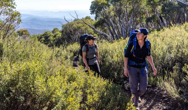
Hiking in Alpine National Park
Explore some of Australia's best mountain walking around Mount Bogong, including the Staircase, Eskdale Spur and a variety of other day hikes and family walks.
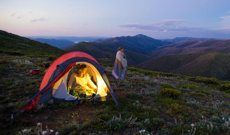
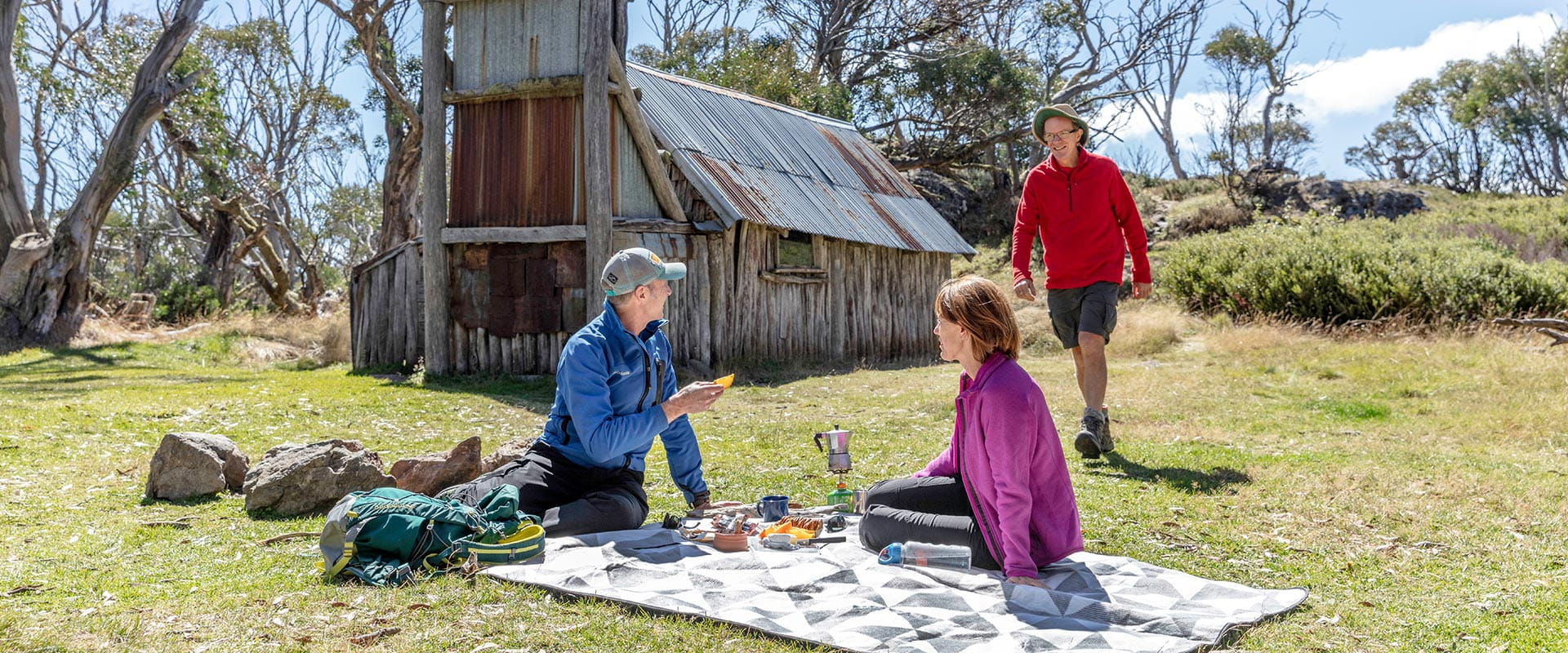
Dispersed camping in Alpine National Park
The Alpine National Park offers some of the most authentic and scenic bush camping opportunities in Victoria.
How to get there
Historic huts in Alpine National Park
Walking is one of the best ways to discover the variety and beauty of the alpine environment. The day walks described in this leaflet are just a selection from many possibilities. The walking season lasts from early November until late May as the area is usually snow covered during winter and early spring. Park cars on the roadside and not on the native snow grasses, which are easily damaged.
When you're there
All visitors, especially walkers, should realise that weather conditions can change rapidly in alpine areas. Snowfalls can be experienced at any time of the year and water can be extremely scarce, so always be prepared with;
• warm clothing
• wind and waterproof jacket
• gloves, hat, sunglasses and strong footwear
• energy food and water
• compass and relevant topographical map
• warm clothing
• wind and waterproof jacket
• gloves, hat, sunglasses and strong footwear
• energy food and water
• compass and relevant topographical map
Need to know
Historic huts in Alpine National Park
Accessibility
Visiting a park can be more of a challenge for people with disabilities, however in Victoria there are a wide range of facilities to help people of all abilities enjoy our wonderful parks around the state.
Change of Conditions
Nature being nature, sometimes conditions can change at short notice. It’s a good idea to check this page ahead of your visit for any updates.
-
Alpine National Park
TRACK CLOSURE: Little Cobbler Track, Alpine National Park
Due to the poor condition of the Little Cobbler Track, it is closed. The track has suffered significant impacts from multiple flood and storm events that has left deep ruts that are not trafficable, making use of the track unsafe.There are multiple 4WD options for alternate routes between Lake Cobbler Road and Speculation Road areas. Options include;- via Cobbler Lake Track. Turn off Lake Cobbler Rd onto Cobbler Lake Track thru to Speculation Road.
- via Wild Horse Gap Track. Turn off Lake Cobbler Rd onto Wild Horse Gap Track, turn onto Burnt Top Track and follow thru to Pineapple Flat. From Pineapple Flat take King Basin Road thru to Speculation Road.
- via Basin Track. Turn off Upper Rose River Rd onto Basin Track, turn onto Burnt Top Track and follow thru to Pineapple Flat. From Pineapple Flat take King Basin Road thru to Speculation Road.
Please contact Parks Victoria on 13 19 63 if you need further assistance with journey planning in this area to assist with navigating around this closure.Cobberas, Ingeegoodbee and Macfarlane Flat Track closures.
The following tracks have been significantly damaged by storms and floods and are currently closed to motor vehicles to ensure public safety and environmental protection:- Cobberas Track
- Macfarlane Flat Track
- Ingeegoodbee Track
The tracks are likely to remain closed to motor vehicles until detailed site assessments have been completed. It is difficult to predict when planning approvals will be obtained to allow for repairs to commence.
Before visiting, visitors should check the Parks Victoria website for the latest information about their destination.Attachments: FAQs for Cobberas ingeegoodbee and mcfarlane tks (128KB)
Wonnangatta Complex Fire - Area and Road Closures - North East
Closed sites/tracks include:- Rileys, Humffray River, Whites & Water Spur Tracks.Open areas:- Access to the Wonnangatta Valley via East Buffalo Road, East Riley, Zeka Spur and Wonnangatta Tracks.- West Buffalo, Harry Shephards, & Penny Track- West Humffray River Track- Australian Alps Walking Track- King Hut- King Billy Track through to Howitt Road- Cobbler Lake Track, Speculation Rd & Lake Cobbler- The Bogong High Plains- Mt Feathertop and Mt Loch areas- Mt Bogong- Walking tracks between Falls Creek and Mt Hotham- Mt Buffalo- Visitor sites accessed from the Omeo Highway- Howqua Hills- Lake Cobbler- Beveridges Station- Twins Tk, Selwyn Ck Tk, Mt Murray South Track
Please see FFM closure map for https://www.ffm.vic.gov.au/permits-and-regulations/closures-of-parks-and-forestsAlpine National Park: road and track closures
These roads and tracks are closed due to current weather conditions at alpine elevations:
- Dargo High Plains Road
- Blue Rag Range Track
- Basalt North Track
- Twins Track
- Twins Jeep Track
- Mount Murray Track North
- Gunns Track
These tracks will remain closed until seasonal closure openings on 29 October 2026.In the interest of public safety, Victoria Police, Department of Energy Environment and Climate Action (DEECA) and Parks Victoria closed these high elevation alpine roads and tracks in State Forest and the Alpine National Park.Wonnangatta Complex Fire - Debris and Fallen Trees
Due to the recent Wonnangatta Complex Fire – Park Visitors may experience increased amount of debris and fallen trees along the track and road network.Whilst every effort will be made to keep tracks open and safe, post bushfire conditions may mean that tracks and roads may change in condition quickly.Please be aware and suitably prepared if visiting opened areas within the fire effected areas. -
Notices Affecting Multiple Sites
MARATHON ROAD CLOSURE
Marathon Road is currently closed at New Place Creek whilst culvert replacement works take place. Access around this closure and works site for through traffic is still available, for four wheel drive only, by following Rim Track.Wonnangatta Complex Fire - Area and Road Closures - Gippsland Alps
Certain Tracks and Sites in the Alpine National Park and Grant Historic Area remain CLOSED - Due to the Dargo Wonnangatta complex fires in the area
Closed Sites/Tracks:
- McMillans walking track within the closure area
- National Horse Trail from Wonnangatta Valley to Dargo within the closure area
- Pinnacles Day visitor area and viewing platform. Closed at junction of Pinnacles Road and Billy Goat Bluff Track Intersection.
- Certain Areas within the Grant Historic Area.
- Pioneer Racecourse Camping Areas (Alpine National Park)
- CLOSED Tracks include: Hern Spur Track, Scrubby Creek Track, Mccarthy Spur Track, Castleburn Track, Black Range Track, 65 Fire Trail Track, Junction Spur Track
Open areas
Open areas include:
- Wonnangatta Valley including access from Dargo
- Wellington Campsites on Tamboritha Road
- Wellington River Trailhead to Lake Tali Karng
- Thomastown Camping area, Kelly Hut, McMichaels Hut
- King Spur Track into Mayford
- Alpine National Park beyond Hotham Heights to the north and to Omeo
- Avon Wilderness Park
- Howitt Road
- Tamboritha Road
- King Billy Track
- Mt Howitt Carpark
- Vallejo Gantner Hut
- Macalister Springs
- Mount Howitt Walking Track
- Howitt Hut
- Bryces Gorge
- Horseyard Flat
- MacFarlane Saddle access to Tali Karng northern trail network.
- Moroka Hut
- Blue Rag Range
- Dargo High Plains including Mayford.
- Billy Goat Bluff Track
- Talbotville Camping Ground via McMillans Road
- McMillans Road from Dargo High Plains Rd to Talbotville Camping Area.
- Eaglevale Camping Area.
Please see FFM closure map https://www.ffm.vic.gov.au/permits-and-regulations/closures-of-parks-and-forestsRoading works Howitt Rd, Moroka Rd and Tamboritha Rd
Road works are taking place on Howitt Road, Moroka Road and Tamboritha Road. Heavy machinery will be present including traffic management points. Please drive to the conditions and comply with road safety signage and traffic management direction. -
Beveridge Station Camping Area (UNKNOWN)
Change of Condition Alpine NP – Road & Track Closures:
Dargo High Plains Road, Blue Rag Range Track, Basalt North Track, Twins Track, Twins Jeep Track, Mount Murray Track North and Gunns Track.Due to current weather conditions at alpine elevations and in the interest of public safety Victoria Police, Department of Energy Environment and Climate Action (DEECA) and Parks Victoria will be closing the above-mentioned high elevation alpine roads and tracks in State Forest and the Alpine NP. These tracks will now remain closed until seasonal closure openings on the 29th of October 2026. -
Notices Affecting Multiple Parks
Planned aerial shooting operations targeting deer
Control operations (aerial shooting) targeting deer are planned for this area. During operations parts of the Park will be closed to visitors. More information on closures will be posted a minimum of 4 weeks prior to commencement.Visitors are advised to check the Change of conditions listing prior to arrival for up to date information and maps.For more information about deer control to protect biodiversity, please visit this link.Ground shooting operations targeting deer
Control operations (ground shooting) targeting deer are undertaken in this area. The Park will remain open to visitors during operations.
For more information about deer control to protect biodiversity, please visit our Deer page.
Wonnangatta Complex Fire - Debris and Fallen Trees
Due to the recent Wonnangatta Complex Fire – Park Visitors may experience increased amount of debris and fallen trees along the track and road network.Whilst every effort will be made to keep tracks open and safe, post bushfire conditions may mean that tracks and roads may change in condition quickly.Please be aware and suitably prepared if visiting opened areas within the fire effected areas.