Nestled in the heart of the Alpine National Park, Mount Beauty and the Bogong High Plains offer a plethora of activities for thrill-seekers. Ski the seemingly endless runs and ride the world-class mountain bike trails of Falls Creek, set out on an overnight adventure along the Falls to Hotham Alpine Crossing or tackle Victoria’s highest peak, Mount Bogong.
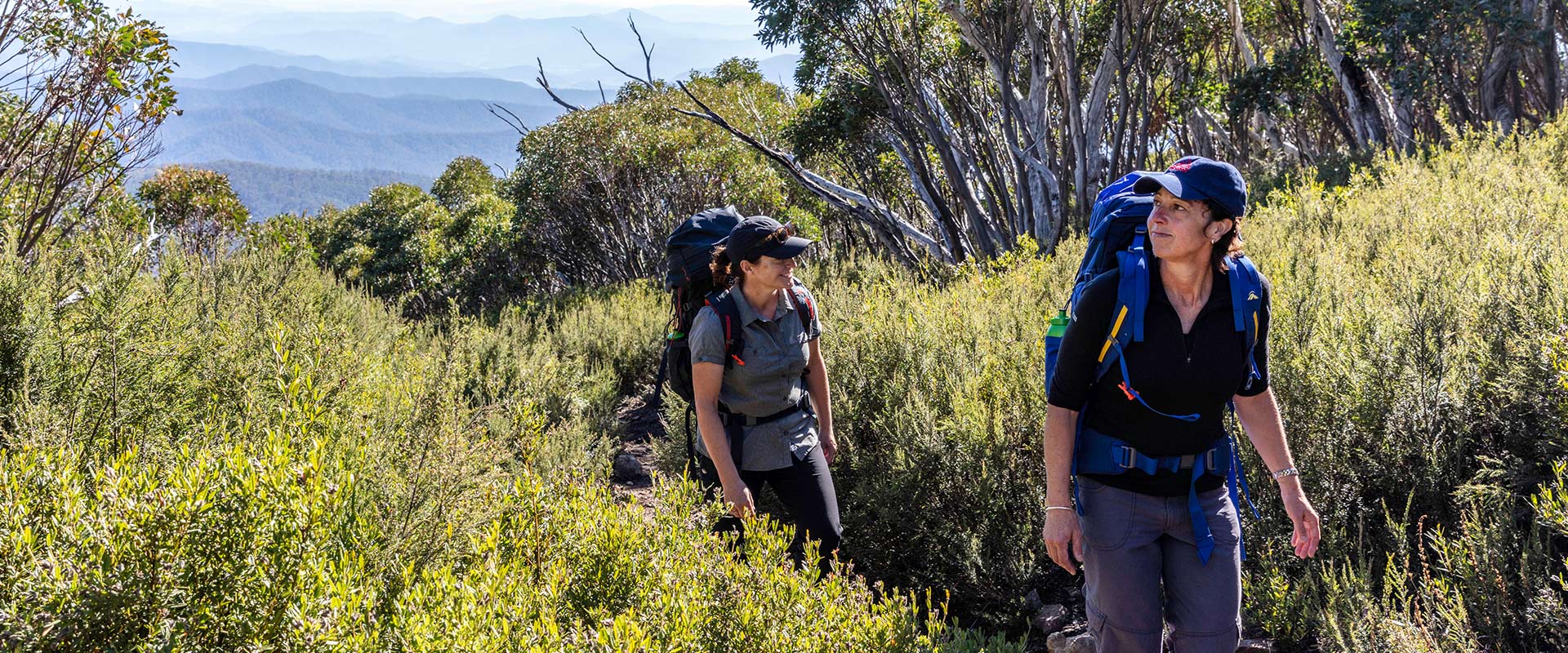
While the ski resort of Falls Creek lies outside the Alpine National Park, it is the perfect launch pad for those wanting to experience some of the best back-country skiing in Victoria, the thrill of mountain biking, hikes through wildflower-littered landscapes and unforgettable alpine vistas.
Don’t be put off by the myth that mountain biking is only for the daring. Falls Creek has over 40km of world-class gravity trails nestled high on the alpine plains. Accessible to the newest of mountain-bikers, pick from easy cruises to fun-flowing descents and all-mountain trails. Swap the mountain bike for a sturdy road bike and pedal through the stunning Tawonga Gap and to towering heights on the climb to the peaks of Mount Beauty or Falls Creek.
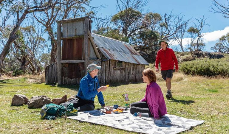
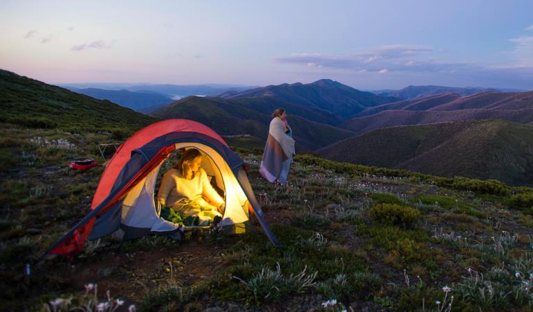
Be both challenged and rewarded over the three-day Falls to Hotham Alpine Crossing. The 37km trail treks over high alpine ridgelines and plains, through river valleys, wetlands thriving with birdlife and panorama-prone landscapes. Sleep out under the stars and discover the remnants of the regions rich cattleman history.
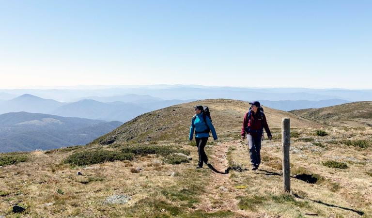
Conquer Victoria’s highest peak, Mount Bogong. Standing 1,986m tall, the long journey to the top tests even the most experienced of hikers. Climb through tall Peppermint and stunted Snow Gum forest before emerging on top of the world. Take in the uninterrupted views across the Alps, before descending back to base.
Things To Do
Alpine Discovery Days
Mount Bogong
Dispersed camping in Alpine National Park
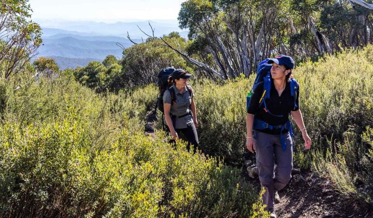
Hiking in Alpine National Park
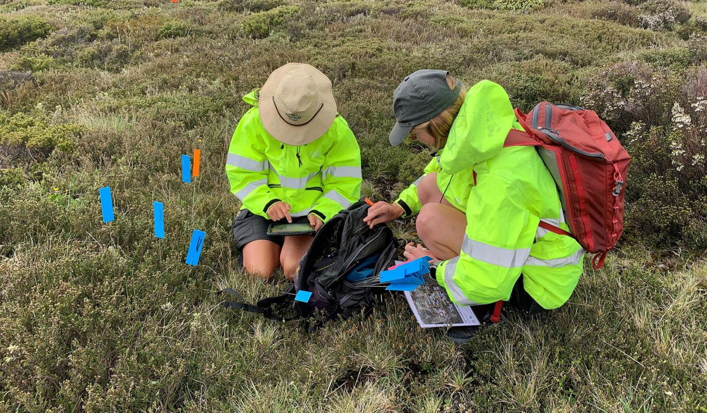
Hawkweed Eradication Project
Each Summer, Parks Victoria coordinates field days in the Alpine National Park and Falls Creek Alpine Resort that allow volunteers to contribute to the Hawkweed Eradication Program.
Updates on the program are published in a volunteer newsletter at the end of each survey season.
View or download the newsletters:
How to get there
Mount Beauty and Bogong High Plains
Alpine back country winter safety
When to go
The best time to explore the Alpine National Park on foot is between November and April. The mild summer temperatures found in the high altitudes of the Alpine National Park are the perfect retreat from its lower-lying counterparts and make for perfect hiking conditions. While the occasional sunny day can see daytime temperatures rise above 30°C, the nights are still cool.
The rivers in the Alps flow rich and fly-fishing on the Ovens River is at its best in early-January. Trout are plentiful and the added bonus of the beautiful river valley is sure to impress too!
Need to know
Mount Beauty and Bogong High Plains
Accessibility
An all-terrain wheelchair known as the TrailRider is available for free hire from the Mount Beauty Visitor Information Centre. Visitors must supply their own helmets. For more information, contact the Mount Beauty Visitor Information Centre on 1800 11 885.
Assistance dogs are welcome in Parks Victoria parks and reserves. Entry requirements apply for parks and reserves that are usually dog prohibited, such as national parks.
Change of Conditions
Nature being nature, sometimes conditions can change at short notice. It’s a good idea to check this page ahead of your visit for any updates.
-
Alpine National Park
Cobberas, Ingeegoodbee and Macfarlane Flat Track closures.
The following tracks have been significantly damaged by storms and floods and are currently closed to motor vehicles to ensure public safety and environmental protection:- Cobberas Track
- Macfarlane Flat Track
- Ingeegoodbee Track
The tracks are likely to remain closed to motor vehicles until detailed site assessments have been completed. It is difficult to predict when planning approvals will be obtained to allow for repairs to commence.
Before visiting, visitors should check the Parks Victoria website for the latest information about their destination.Attachments: FAQs for Cobberas ingeegoodbee and mcfarlane tks (128KB)
Wonnangatta Complex Fire - Area and Road Closures - North East
Closed sites/tracks include:- Rileys, Humffray River, Whites & Water Spur Tracks.Open areas:- Access to the Wonnangatta Valley via East Buffalo Road, East Riley, Zeka Spur and Wonnangatta Tracks.- West Buffalo, Harry Shephards, & Penny Track- West Humffray River Track- Australian Alps Walking Track- King Hut- King Billy Track through to Howitt Road- Cobbler Lake Track, Speculation Rd & Lake Cobbler- The Bogong High Plains- Mt Feathertop and Mt Loch areas- Mt Bogong- Walking tracks between Falls Creek and Mt Hotham- Mt Buffalo- Visitor sites accessed from the Omeo Highway- Howqua Hills- Lake Cobbler- Beveridges Station- Twins Tk, Selwyn Ck Tk, Mt Murray South Track
Please see FFM closure map for https://www.ffm.vic.gov.au/permits-and-regulations/closures-of-parks-and-forestsAlpine National Park: road and track closures
These roads and tracks are closed due to current weather conditions at alpine elevations:
- Dargo High Plains Road
- Blue Rag Range Track
- Basalt North Track
- Twins Track
- Twins Jeep Track
- Mount Murray Track North
- Gunns Track
These tracks will remain closed until seasonal closure openings on 29 October 2026.In the interest of public safety, Victoria Police, Department of Energy Environment and Climate Action (DEECA) and Parks Victoria closed these high elevation alpine roads and tracks in State Forest and the Alpine National Park.Wonnangatta Complex Fire - Debris and Fallen Trees
Due to the recent Wonnangatta Complex Fire – Park Visitors may experience increased amount of debris and fallen trees along the track and road network.Whilst every effort will be made to keep tracks open and safe, post bushfire conditions may mean that tracks and roads may change in condition quickly.Please be aware and suitably prepared if visiting opened areas within the fire effected areas.Ground shooting operations targeting deer
Control operations (ground shooting) targeting deer are undertaken in this area. The Park will remain open to visitors during these operations.For more information about Parks Victoria deer control to protect biodiversity, please visit: https://www.parks.vic.gov.au/get-into-nature/conservation-and-science/conserving-our-parks/feral-animals/deer -
Beveridge Station Camping Area (Alpine National Park, UNKNOWN)
Change of Condition Alpine NP – Road & Track Closures:
Dargo High Plains Road, Blue Rag Range Track, Basalt North Track, Twins Track, Twins Jeep Track, Mount Murray Track North and Gunns Track.Due to current weather conditions at alpine elevations and in the interest of public safety Victoria Police, Department of Energy Environment and Climate Action (DEECA) and Parks Victoria will be closing the above-mentioned high elevation alpine roads and tracks in State Forest and the Alpine NP. These tracks will now remain closed until seasonal closure openings on the 29th of October 2026. -
Notices Affecting Multiple Sites
Wonnangatta Complex Fire - Area and Road Closures - Gippsland Alps
Certain Tracks and Sites in the Alpine National Park and Grant Historic Area remain CLOSED - Due to the Dargo Wonnangatta complex fires in the area
Closed Sites/Tracks:
- McMillans walking track within the closure area
- National Horse Trail from Wonnangatta Valley to Dargo within the closure area
- Pinnacles Day visitor area and viewing platform. Closed at junction of Pinnacles Road and Billy Goat Bluff Track Intersection.
- Certain Areas within the Grant Historic Area.
- Pioneer Racecourse Camping Areas (Alpine National Park)
- CLOSED Tracks include: Hern Spur Track, Scrubby Creek Track, Mccarthy Spur Track, Castleburn Track, Black Range Track, 65 Fire Trail Track, Junction Spur Track
Open areas
Open areas include:
- Wonnangatta Valley including access from Dargo
- Wellington Campsites on Tamboritha Road
- Wellington River Trailhead to Lake Tali Karng
- Thomastown Camping area, Kelly Hut, McMichaels Hut
- King Spur Track into Mayford
- Alpine National Park beyond Hotham Heights to the north and to Omeo
- Avon Wilderness Park
- Howitt Road
- Tamboritha Road
- King Billy Track
- Mt Howitt Carpark
- Vallejo Gantner Hut
- Macalister Springs
- Mount Howitt Walking Track
- Howitt Hut
- Bryces Gorge
- Horseyard Flat
- MacFarlane Saddle access to Tali Karng northern trail network.
- Moroka Hut
- Blue Rag Range
- Dargo High Plains including Mayford.
- Billy Goat Bluff Track
- Talbotville Camping Ground via McMillans Road
- McMillans Road from Dargo High Plains Rd to Talbotville Camping Area.
- Eaglevale Camping Area.
Please see FFM closure map https://www.ffm.vic.gov.au/permits-and-regulations/closures-of-parks-and-forests