Extent and representation of natural assets and ecosystem services in parks
State of the Parks Fourth Edition
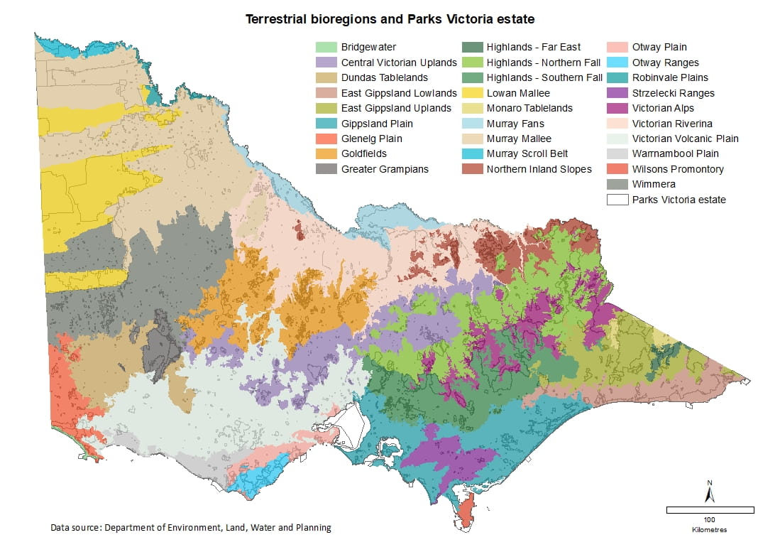
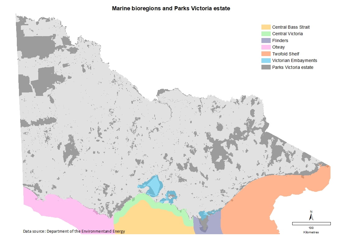
Victoria can be divided into 28 terrestrial bioregions; large land areas characterised by similar natural features and environmental processes that influence the functions of entire ecosystems, and five marine bioregions, large areas of the sea that can be grouped according to characteristics such as currents, wave energy, seawater temperature, geology and geography.
The parks network protects a great variety of native vegetation types, from wetlands and forests to coastal heath and grasslands, some of which are rare and depleted. Vegetation types (Ecological Vegetation Divisions or EVDs) reflect the climate, soils and topography of an area.
Parks also play an important role in conserving the diversity of the state’s native flora and fauna and provide refuge to many threatened flora and fauna species. They allow for the evolutionary potential of species, provide climate change refugia and can contribute to the resilience of broader landscapes.
Indicators
Representation of terrestrial bioregions in parks
Representation of marine bioregions in parks
Extent and representation of native vegetation in parks
Extent and representation of marine habitats in parks
Extent and representation of wetlands in parks
Representation of flora and fauna in terrestrial parks
Significance of park habitats for threatened species
Representation of marine flora and fauna
Representation of terrestrial bioregions in parks
- The proportion of bioregions protected in parks ranges from 100% of the Wilsons Promontory bioregion to just over 1% of the Dundas Tablelands bioregion.
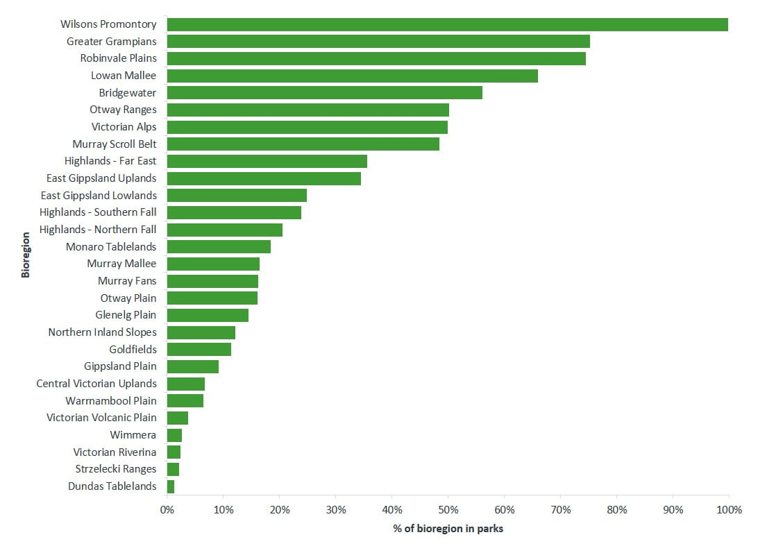
Data source: DELWP
Representation of marine bioregions in parks
- Of the five marine bioregions off Victoria’s coastline, the Victorian Embayments bioregion is the most well represented in parks, with more than 60 per cent of its area protected. Central Victoria, Flinders, Twofold Shelf and Otway have 2% or less of their area protected in parks.
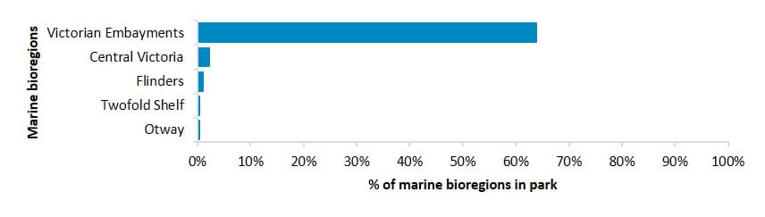
Data source: Department of the Environment and Energy
Extent and representation of native vegetation in parks
- All Ecological Vegetation Divisions are represented within parks, although the extent of representation varies widely: Hummock-grass Mallee is the most well-reserved with 86% protected in parks while the least represented is Basalt Grassland, with just 3.8% of its area present in parks.
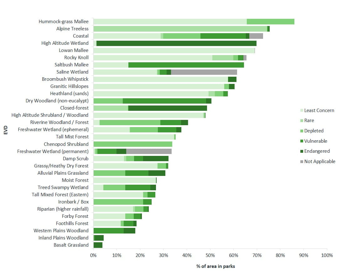
Data source: DELWP
Extent and representation of marine habitats in parks
- Around five per cent of Victorian marine waters are protected by marine national parks and marine sanctuaries. Other marine protected areas include marine parks, marine and coastal parks, and a marine reserve.
- The habitats found within these marine protected areas include seagrass meadows, mangroves, saltmarsh, rocky reefs and soft sediment.
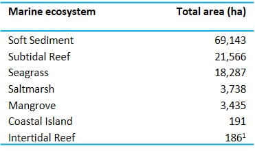
1. Only includes intertidal reefs in Marine Protected Areas. Intertidal reefs that fall within terrestrial (coastal) parks have not yet been accurately estimated, but are a significantly larger area.
Data source: Parks Victoria
Extent and representation of wetlands in parks
Victorian wetland classification framework, developed in 2014, identifies twenty wetland types based on wetland system, salinity regime, water regime and dominant vegetation.
Extent and representation of wetland types in parks
- Seven wetland types have more than 60% of their area within the parks estate.
- Permanent freshwater swamps/marshes/meadows and intertidal flats are the most well represented wetlands in the parks network, while permanent saline and freshwater swamps are the least represented.
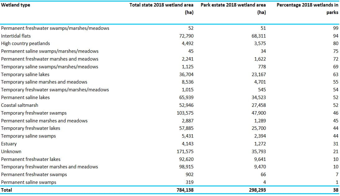
Data source: DELWP
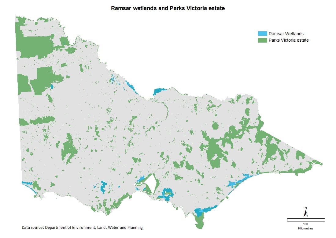
Extent and representation of Ramsar wetlands in parks
- Eleven of the 12 internationally significant Ramsar wetlands found in Victoria are entirely or partially managed by Parks Victoria.
- The Glenelg Estuary and Discovery Bay is Victoria’s newest Ramsar site. Listed in February 2018, the site includes the majority of Lower Glenelg National Park and Discovery Bay Coastal Park.
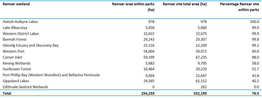
Data source: DELWP
Representation of flora and fauna in terrestrial parks
Parks play an important role in conserving the diversity of the state’s native flora and fauna. In 2018, 4,997 native species of flora and 1,677 native species of fauna were known to be present in Victoria’s parks network. The number of species recorded was boosted by an increase in new species records, as well as changes to species taxonomy.
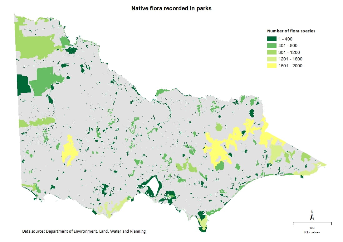
Native flora species in parks
- Of the 5,405 native flora species recorded in Victoria, 92 per cent (4,997) are present in the state’s terrestrial and marine protected areas (Source: Victorian Biodiversity Atlas).
- The Alpine National Park has the highest number of native flora species recorded followed by the Grampians, Great Otway and Snowy River national parks. There are 13 terrestrial parks that have over 800 species recorded.
Parks with more than 800 native flora species
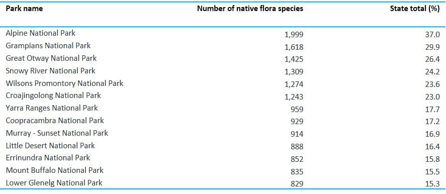
Data source: DELWP
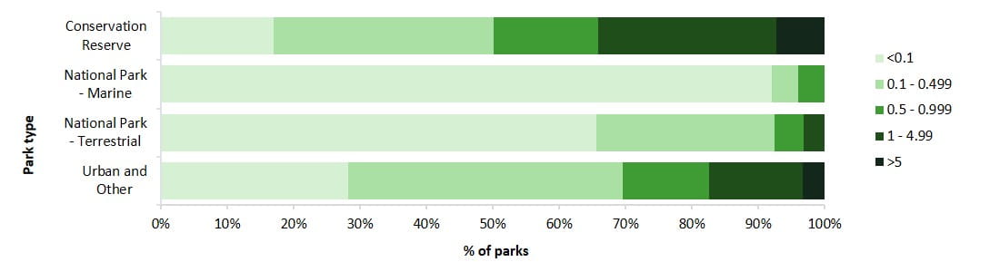
Number of flora species per hectare as a ratio
- Conservation reserves account for the highest proportion of park type which contain one or more species per hectare (34%). This highlights their importance in conserving flora species, even though more than 90% of these reserves are very small (less than 400 ha).
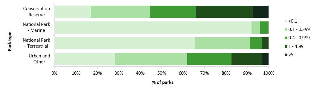
Data source: DELWP
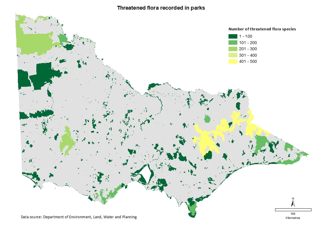
Rare and threatened flora species in parks
- Of Victoria’s 1,902 listed rare and threatened flora species, 90% are recorded in parks, with 11 parks containing more than 100 species.
- Alpine National Park has by far the largest number of rare and threatened flora species, with ten other parks having more than 100 rare and threatened species recorded.
Parks with more than 100 rare and threatened species recorded

Data source: DELWP
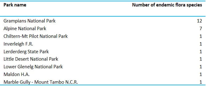
Endemic flora species in parks
- 344 species of flora are endemic to (only found in) Victoria. Of these, 36 species are endemic to a single park.
- The Grampians and Alpine national parks have the highest number of endemic species.
Flora species endemic to a park
Data source: DELWP
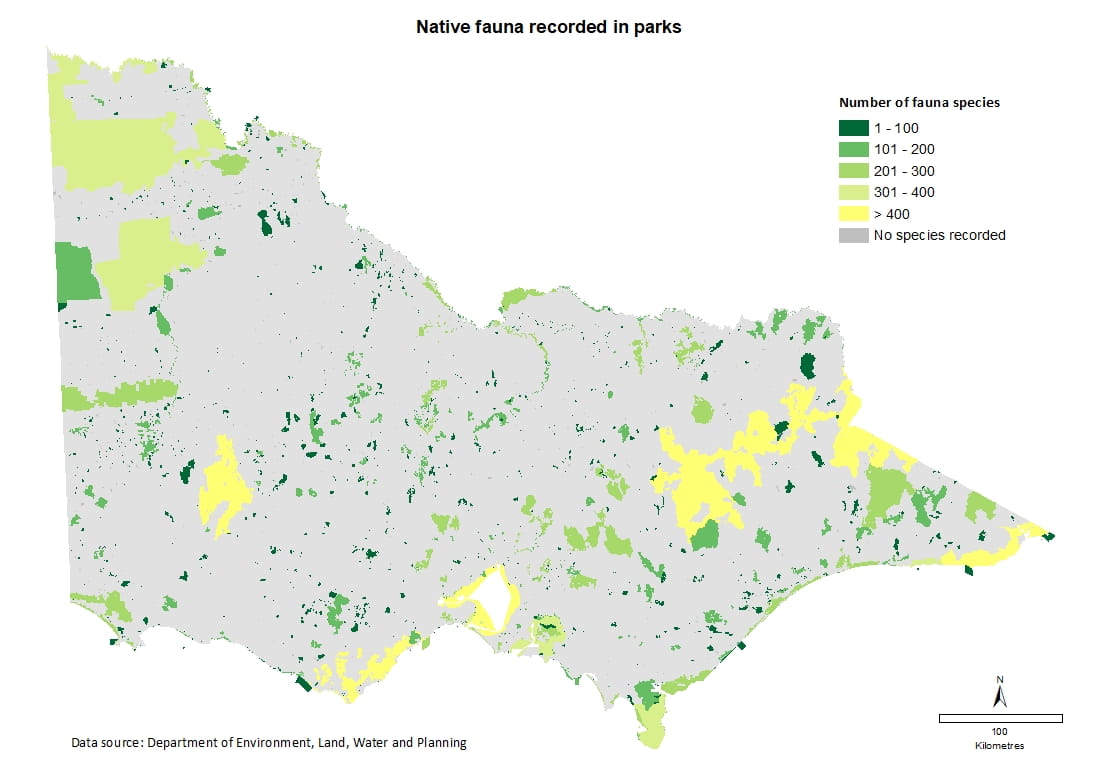
Native fauna species in parks
- Of the 2,204 native fauna species recorded in Victoria, 1,677 (76%) are present in terrestrial and marine parks.
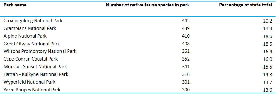
- Terrestrial parks with the greatest number of fauna species include Croajingolong, Grampians, Alpine and Great Otway national parks. Ten terrestrial parks have more than 300 native fauna species recorded.
Terrestrial parks with more than 300 native fauna species
Data source: DELWP
Representation of faunal groups in parks
- Of the 1,677 recorded faunal species in the parks network, invertebrates (643 species) and birds (451 species) are the most represented faunal groups.
Representation of faunal groups in parks
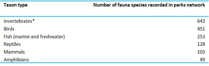
*Includes terrestrial, freshwater and marine invertebrates
Data source: DELWP
Number of fauna species per hectare as a ratio
- Conservation reserves and Urban and Other parks have a higher number of fauna species per hectare than National Park Act parks. This highlights the important role that these smaller reserves can play in complementing the National Parks system and building more resilient landscapes.
Data source: DELWP
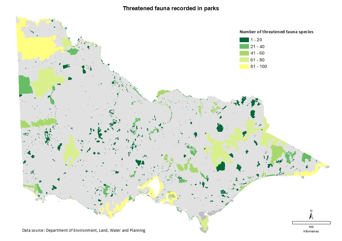
Rare and threatened fauna species in parks
- In 2018 there were 347 listed threatened fauna species recorded in Victoria’s parks network, which represented 89.2% of the state’s listed threatened fauna species.
- Croajingolong and Murray-Sunset national parks are home to the largest number of rare and threatened species found across the parks network. In total, 16 parks have 50 or more rare or threatened fauna recorded.
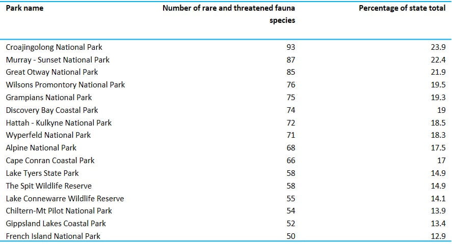
Data source: DELWP
Number of terrestrial vertebrate fauna species endemic to a park
- Four terrestrial vertebrate animal species endemic to a park have been recorded.
- Three of the four endemic animals occur in parks located in the Victorian Alps.
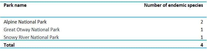
Data source: DELWP
3.1.7. Significance of park habitats for threatened species
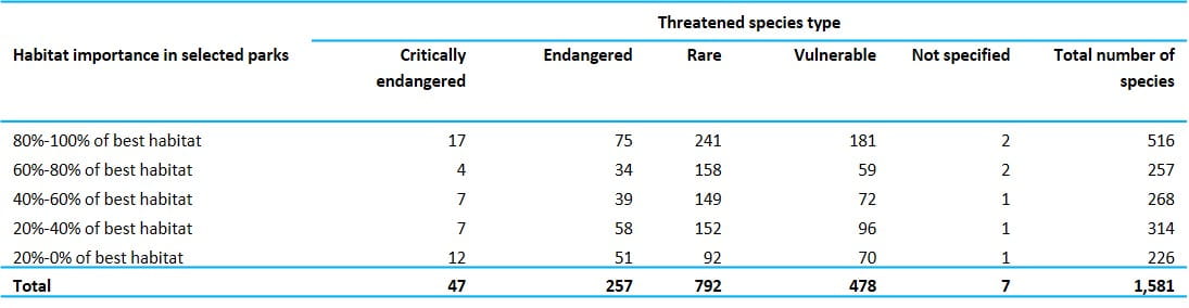
Number of species for which national parks and nature conservation reserves provide best habitat
- Habitat suitability modelling for threatened species, covering 638 Victorian parks and reserves (including all national parks and larger conservation reserves) indicated that these parks provide 516 threatened species with at least 80 per cent of important available habitat in the state.
Data source: DELWP
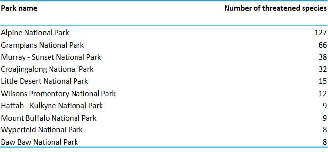
Top 10 parks with greater than 80% of best habitat suitability in the state
- The Alpine National Park contains the highest number of threatened species (127) for which it provides at least 80 per cent of the modelled best habitat suitability for that species, followed by the Grampians National Park (66 species).
Data source: DELWP
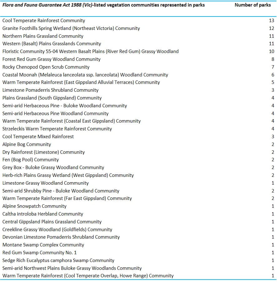
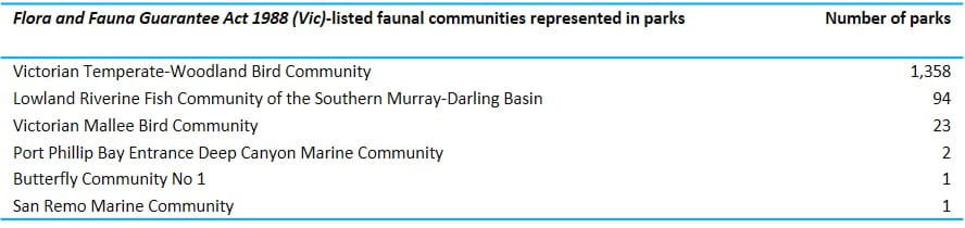
Number and distribution of Flora and Fauna Guarantee Act 1988 (Vic)-listed vegetation and faunal communities recorded in park
- Of the 41 flora and fauna communities listed as threatened under the Flora and Fauna Guarantee Act 1988 (Vic), 40 can be found in the parks network (34 flora and 6 fauna).
Data source: DELWP
Data source: DELWP
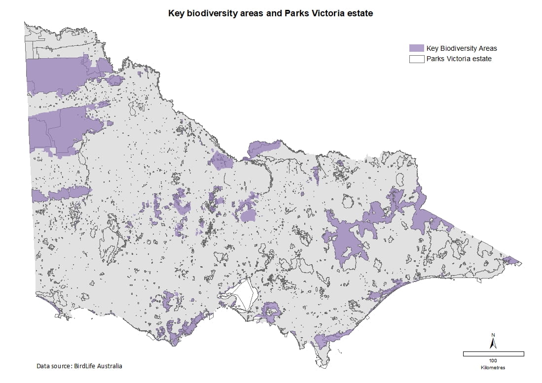
Key Biodiversity Areas
Key Biodiversity Areas (KBA) represent the most important sites for biodiversity conservation worldwide, and are identified using globally standardised criteria. They include vital habitat for threatened plant and animal species in terrestrial, freshwater and marine ecosystems.
As of 2018, 37 of the KBAs declared in Australia occurred in Victoria and 36 of these sites (78% of their total area) were in parks. Five KBAs are shared between Victoria and other states. In total, 14 KBAs in Victoria have more than 80% of their area protected in parks.
Percentage of Key Biodiversity Area (KBA) in parks
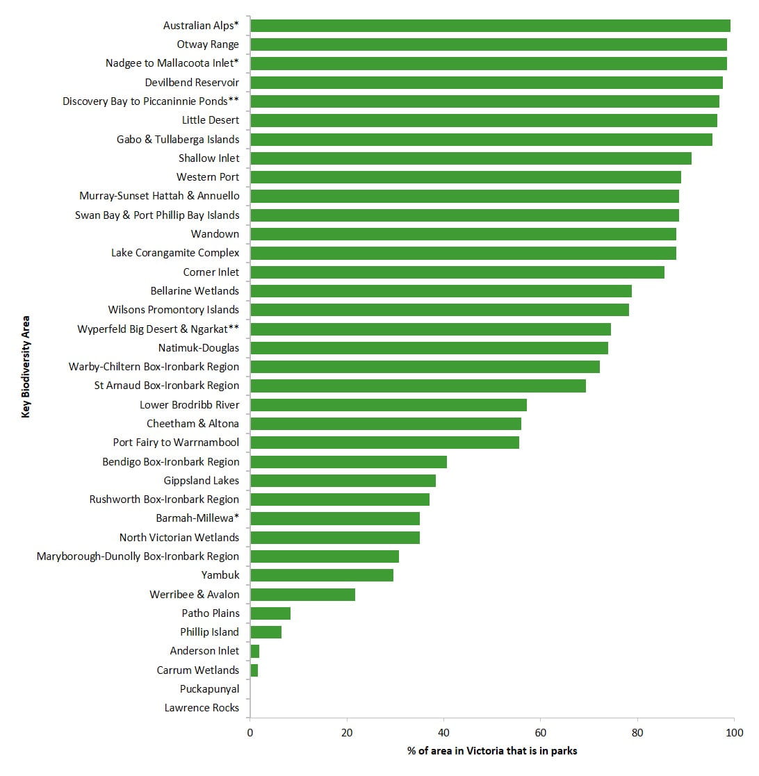
*KBA shared between Victoria and New South Wales
**KBA shared between Victoria and South Australia
Data source: BirdLife Australia
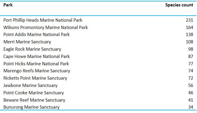
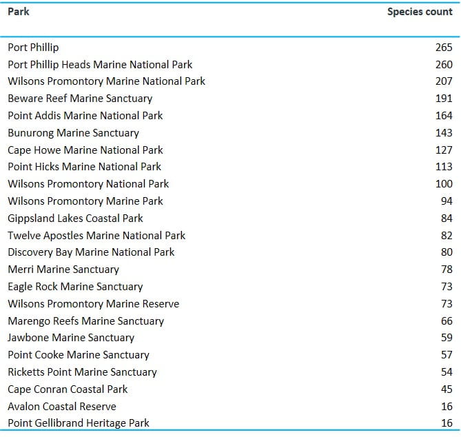
Representation of marine flora and fauna
Marine flora and fauna species in parks
- Greater numbers of marine flora and fauna species have been recorded in the Port Phillip Heads and Wilsons Promontory marine national parks, reflecting both survey effort and their size.
Number of marine flora and algae species in parks*
*Marine data were derived from monitoring surveys including the Subtidal Reef Monitoring Program (SRMP), Reel Life Survey (RLS) and Baited Remote Underwater Video Stations (BRUVS). These datasets were selected for their scientific rigor and accuracy. Victoria Biodiversity Atlas (VBA) data, included previously in State of the Parks reports, has been excluded. This change in methodology means data cannot be compared with those reported in Victoria’s State of the Parks - Third Edition.
Data source: Parks Victoria and Reef Life Survey
Number of marine fauna species in parks*
*Marine data were derived from monitoring surveys including the Subtidal Reef Monitoring Program (SRMP), Reel Life Survey (RLS) and Baited Remote Underwater Video Stations (BRUVS). These datasets were selected for their scientific rigor and accuracy. Victoria Biodiversity Atlas (VBA) data, included previously in State of the Parks reports, has been excluded. This change in methodology means data cannot be compared with those reported in Victoria’s State of the Parks - Third Edition.
Data source: Parks Victoria and Reef Life Survey
Go to previous section of State of the Parks Fourth Edition: Management for nature conservation
Go to next section of State of the Parks Fourth Edition: Status and management of key threats to park ecosystems