Victorian surveys on feral horses
Parks Victoria manages feral horses in the Alpine National Park and Barmah National Park to reduce the damage they cause to fragile native vegetation, ecosystems and Aboriginal cultural heritage. Monitoring the numbers of horses in these parks helps determine the scale of their impact and the change in horse numbers over time caused by population growth, environmental factors and horse control undertaken by Parks Victoria.
Due to the size, remoteness and difficulty of accessing parks where horses occur (Victoria’s alpine national parks and Barmah National Park), counting every horse is not possible. This is also the case for most fauna populations in the wild – it’s a very rare situation when you can census the entire population. Instead, various internationally-recognised and commonly used scientific methods are used to determine horse numbers from the monitoring that can be undertaken.
The survey methods and results for Barmah National Park and two sections of the Alpine National Park, Bogong High Plains and Eastern Alps, are summarised below.
Estimated size of horse populations in Victoria based on scientific surveys and expert analyses
| Barmah National Park | Bogong High Plains, Alpine National Park | Eastern Alps: Alpine National Park and adjoining public land |
|
| 2021 |
328 horses The population is likely between 169 and 635 horses |
252 horses The population is likely between 195 and 350 horses.
|
2456 horses
|
| 2019 |
621 horses
|
5110 horses |
|
| 2018 | 1088 horses
The population is likely between 752 and 1423 horses.
|
109 horses
The population is likely between 107 and 123 horses. |
|
| Earlier | Various adhoc surveys using unsystematic methods |
2015: 63 horses
|
2014: 2590 horses |
Barmah National Park
Barmah National Park is a 28,537 hectare park situated on the border with NSW, with its northern edge defined by the Murray River. Aerial surveys of horses were trialed in June 2017, and repeated in June of 2018 and 2019, and November 2021, as described below.
Since 2021, feral horse control and flood events have reduced the population, and reconnaissance flights over likely horse-occupied habitats in October 2023 observed 40 horses, which could be regarded as a minimum number at that time.
With feral horse numbers now at very low levels, the surveillance approach and frequency will be revised to enable the detection of any remaining feral horses or horses released into the Barmah National Park, and ensure that there is a rapid management response to remove those horses.
Past survey area and method
Thermal imaging data was captured from an imaging system mounted to a helicopter that was flown along parallel transects, 1000 metres apart, across portions of the Barmah National Park, as shown on the map below which represents the 2021 survey (Figure 1). This technique relies on a stark temperature contrast between the animal and the ground, so the surveys need to be flown in colder weather, or at colder times of day. The technique has the advantage of allowing horses to be detected that might otherwise be obscured by red gum canopy cover and tall reed beds.
Horses were detected from the recorded thermal imagery within 90 metres either side of the transects. Horses were positively identified using a set of rules and records are verified by two skilled analysts operating independently. Estimates were then calculated for the density and abundance of horses across the survey area, including the area between transects, by an independent expert using an internationally recognised method known as Distance Analysis, widely applied for wildlife surveys around the world.

Figure 1: Barmah transect map of the 2021 survey.
In 2017, the flown transects provided a population estimate for approximately 52% of the park. In 2018, 2019 and 2021, the flown transects provided population estimates for approximately 82%, 91% and 91% of the park, respectively. The results for each survey year are summarised below, given with the 95% confidence interval (this is the range of values for which we are 95% confident the true value lies within).
Surveys planned for 2020 had to be deferred until late 2021 due to the operational constraints of COVID-safe settings.
Survey results
2021- Download Analysis of the 2021 aerial survey of the feral horse population in the Barmah National Park
The estimate of the number of horses across the surveyed area was 328 horses, with 95% confidence that the population was at least 169 and could be up to 635.
The estimate of the number of horses across the surveyed area was 621 horses, with 95% confidence that the population was at least 477 and could be up to 765.
This result corrects an erroneous 2019 horse number estimate (540 horses) previously reported in the Strategic Action Plan: Protection of Floodplain Marshes in Barmah National Park and Barmah Forest Ramsar Site, which was calculated using an incorrect survey area (22,967 hectares as opposed to 26,064 hectares). While the estimated population density (0.024 ±0.006 horses per hectare) is the same between the two reports, the larger area of the survey increases the estimate of horse abundance. Parks Victoria acknowledges that the previous estimate was made in error.
A further analysis in the 2019 report compared the 2019 and 2018 horse numbers and determined that horse numbers had declined. The summer of 2018-19 was particularly dry, and more than 50 horses had to be euthanised by Parks Victoria due to their poor condition and welfare concerns caused by lack of natural feed and starvation. This reduction, together with other unaccounted-for deaths, possible reduced birth rate and potential movement of horses in search of food could explain the decline from 2018 to 2019.
2018
The estimate of horse numbers (across the 82% of the park surveyed) was 1088 horses with 95% confidence that the population is at least 752 and could be up to 1,423.
2017
The estimate of horse numbers (across the 52% of the park surveyed) was 675 horses with 95% confidence that the population is at least 551 and could be up to 799.
It is important to note that the 2017 and 2018 abundance estimates are not directly comparable because they are estimates for different areas of the park (52% in 2017 and 82% in 2018).
Previous years
Several horse counts were undertaken prior to 2017, including helicopter counts in summer 2012 which observed at least 144 horses. These counts were all likely to have underestimated the population as they did not systematically survey the area and would not have detected horses within red gum canopy cover and within tall Phragmites reed beds. They are not comparable with the estimates from systematic surveys from 2018 on.
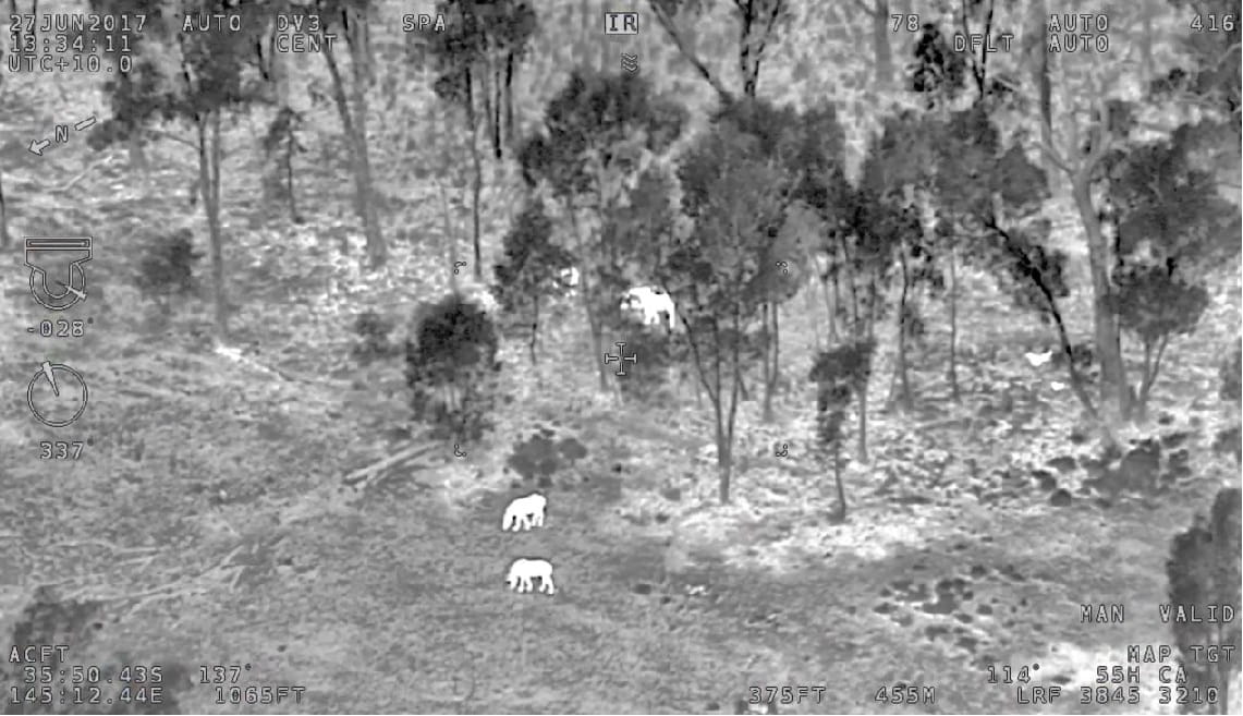 Figure 2: High-resolution infra-red video image of horses feeding in the open and amongst trees, recorded at the time of the 2017 survey.
Bogong High Plains
The Bogong High Plains is a specific area of focus for aerial horse surveys within the Alpine National Park, located to the south of Mount Bogong. Mount Bogong is the highest point in Victoria. This area has been surveyed every 2-3 years since 2005 using a consistent (sight-resight) method. Searches were also conducted over 15,000 hectares of State Forest land to the south of the Bogong High Plains, but this has not been included in the analysis and estimation of horse numbers. In 2018, the search area was extended to include a6000 hectare area around Mount Nelse where horses had relocated to since the previous survey (see Figure 2).
Survey area and method
The same survey area has been covered by each of the surveys undertaken, over an area of approximately 26,000 hectares between Falls Creek and the Bundara River. This area is predominantly in the Alpine National Park, with a small area of State Forest.
The survey method for this area involves human observers in a helicopter flying parallel transects across the park, 1000 metres apart, on two consecutive days. The helicopter flies the same route on both days, with observers locating and identifying horses on the first day and verifying identified horses on the second day. An estimate of horse numbers is then calculated from the sighting and re-sighting data. The results are summarised below, given with the 95% confidence interval (this is the range of values for which we are 95% confident the true value lies within).
An additional survey was completed in June 2021 with the report currently in preparation.
Survey results
2021 – Download Feral Horse Aerial Survey Bogong High Plains and Surrounding Valleys
Horse abundance across the survey area was estimated to be 252 horses with 95% confidence that the population is at least 195 and up to 350.
The 2021 survey used the same method as previous surveys of the area - a sight-resight (mark-recapture) survey method from a helicopter. This survey continues to build on, and compare information obtained from six previous surveys.
The surveys in 2018 and 2021 show that since 2015, the size of the feral horse population on the Bogong High Plains increased, and in 2021 reached the highest level recorded since monitoring began in 2005. This increase coincides with a period when the population was left largely unchecked and little horse removal occurred. The population’s growth rate between 2005 and 2015 was very similar to that between 2015 and 2021 (26% per annum and 29% per annum respectively). However, on average, the removal rate between 2005 and 2015 exceeded the growth rate so the population decreased over that period.
2018 - Download 2018 Aerial Feral Horse Survey Report: Bogong High Plains and surrounding valleys
Horse abundance across the survey area was estimated to be 109 horses with 95% confidence that the population is at least 107 and up to 123.
Previous survey years
Estimates of horse numbers in are as follows (95% confidence intervals in brackets):
- 2015: 63 horses (55-83)
- 2012: 52 horses (51-57)
- 2009: 98 horses (83-133)
- 2007: 95 horses (90-100)
- 2005: 92 horses (81-116)
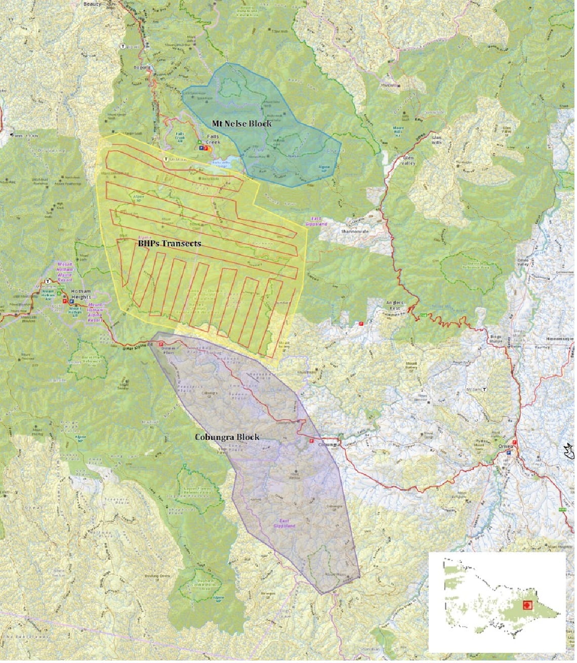
Figure 3: Map showing the search areas (Mt Nelse and Cobungra blocks) and the planned flight transects (red lines in yellow BHP transect block).
Eastern Alps
An aerial survey of the feral horse population in the eastern Victorian Alps was conducted in December, 2021. The survey was conducted using helicopter line transect sampling, and the results were analysed using an internationally recognised method known as Distance Analysis.
Feral horse populations of the Australian Alps National Parks (AANP) have earlier been surveyed using helicopter line transect sampling in 2001, 2003 and 2009, and a report (Cairns 2019) details the results of surveys conducted in April-May of 2014 and April-May of 2019. Horse surveys conducted over the Australian Alps have previously included land in both NSW and Victoria, and counting was not undertaken separately for the two states, making it difficult to extract Victorian-specific numbers for the eastern Victorian Alps.
Following community feedback and concerns about the impacts of the 2019-20 bushfires and after COVID-related delays to surveying, in 2021, Parks Victoria undertook a follow-up survey of the eastern Victorian Alps, south of the NSW-Victoria border.
The 2021 survey covered broadly the same horse-occupied area (3,036.6 km²) of Victoria as the 2014 and 2019 surveys, which were at that time surveyed as part of the larger feral horse surveys for the Australian Alps. The survey area includes covers parts of the Alpine National Park and Snowy River National Park, and adjacent areas of State Forest and other Crown land (see Figure 4).
The survey and analysis methods used were the same as those used for the 2014 and 2019 AANP surveys, which were independently reviewed and validated by experts in the analytical techniques used, from CSIRO and St Andrews University in Scotland.
Survey area and method
The 2021 aerial survey used the same method as for the 2014 and 2019 surveys, involving human observers in a helicopter, generally flying parallel east-west transects across the survey area, locating and counting clusters of horses within a 150-metre wide strip on both sides of the aircraft. A zig-zag path was flown over the Snowy River Valley. Areas of steep country with relief greater than 20 degrees (1172.6 km²) were excluded from the survey for safety reasons and the likelihood they are not being utilised by horses.
The survey was conducted over five consecutive days, and a total of 1071.3 kilometres of transect was flown. With the parallel transect lines being 1.76 km apart the survey was undertaken with a reasonable degree of confidence that there would be no double counting of horses on adjacent transects during a survey session. 78 clusters of horses were observed at distances from 0 to 150 metres on each side of the transect line, with clusters ranging in size from 1 to 13 horses. No horses were observed on Snowy River Valley transects.
Figure 4: Map showing the planned flight transects of the survey.
Survey results
2021 - Download A Survey of the Feral Horse Population in the Victorian Eastern Alps, December 2021 (PDF)
The observations were then used to estimate the density and abundance of horses in the survey area using the analysis program DISTANCE 7.3. The results are summarised as follows, given with 95% confidence intervals (this is the range of values for which we are 95% confident the true value lies within).
The estimated abundance of horses in the survey area at the time of the survey was 2456 horses with the 95% confidence interval ranging from 1088 to 4186. This is based on an estimated density of horses of 1.32 horses per km² in the surveyed area (excluding the unsurveyed area of steep terrain), with the 95% confidence interval ranging from 0.58 to 2.25.
It was also estimated that there were 602 (344-1035) deer in the eastern Victorian Alps at the time of the survey.
The difference between the 2019 estimate for the eastern Victorian Alps area (5110 horses, see below) and the 2021 estimate (2456 horses) are likely due to:
- changes in the 2021 survey design to focus only on the eastern Victorian Alps, which does not support making a direct comparison between the two years
- impact of major bushfires on feral horse populations, which is supported by earlier pre- and post-fire population surveys, including the 2020 Kosciuszko National Park survey (Cairns 2020), that showed a similar scale of reduction
- removal of feral horses from the survey area following the 2019-20 bushfires
- inherent variability when estimating populations over such large areas.
Earlier surveys also show a population growth after fires, and without sufficient intervention to manage abundance, the population will increase following the 2019-20 bushfires. We can use the results of the 2021 survey to examine the possible effects of different levels of removal on feral horse abundance over time.
From the original detection of 374 horses on the transects, the estimate of horse abundance was 8518 horses with 95% confidence that the population was at least 6321 and up to 12,464.
A simple way to estimate Victorian-specific horse numbers from the numbers estimated for the Byadbo-Victorian block is to multiply the number of horses by the percentage of the area that lies within Victoria. With approximately 60% of survey area occurring within Victoria, and assuming that horses are distributed similarly across the Victorian and NSW sections of the survey block, the number of horses in the Eastern Alps area was estimated to be approximately 5110 horses, representing an increase of approximately 15% per year from 2014.
2014
The estimate of horse abundance was 4316 horses with 95% confidence that the population was at least 3316 and up to 6577.
With approximately 60% of survey area occurring within Victoria, and assuming that horses are distributed similarly across the Victorian and NSW sections of the survey block, the number of horses in the (Victorian) Eastern Alps area was approximately 2590 horses.