Nestled on the western edge of the Sandpatch Wilderness Zone, the secluded sandy beaches and pristine rainforest of Wingan Inlet make for a wonderful spot to camp. Canoe or kayak up the Wingan River, cast a line to catch bream and tailor, or wander down to Fly Cove to see fur seals.
Enclosed by tall bloodwood trees, laze the day away in the tranquility of Wingan Inlet with goannas, currawongs and the occasional jumping fish as company. With tailor, bream, trevally, mullet, perch and more, go fishing for your dinner.
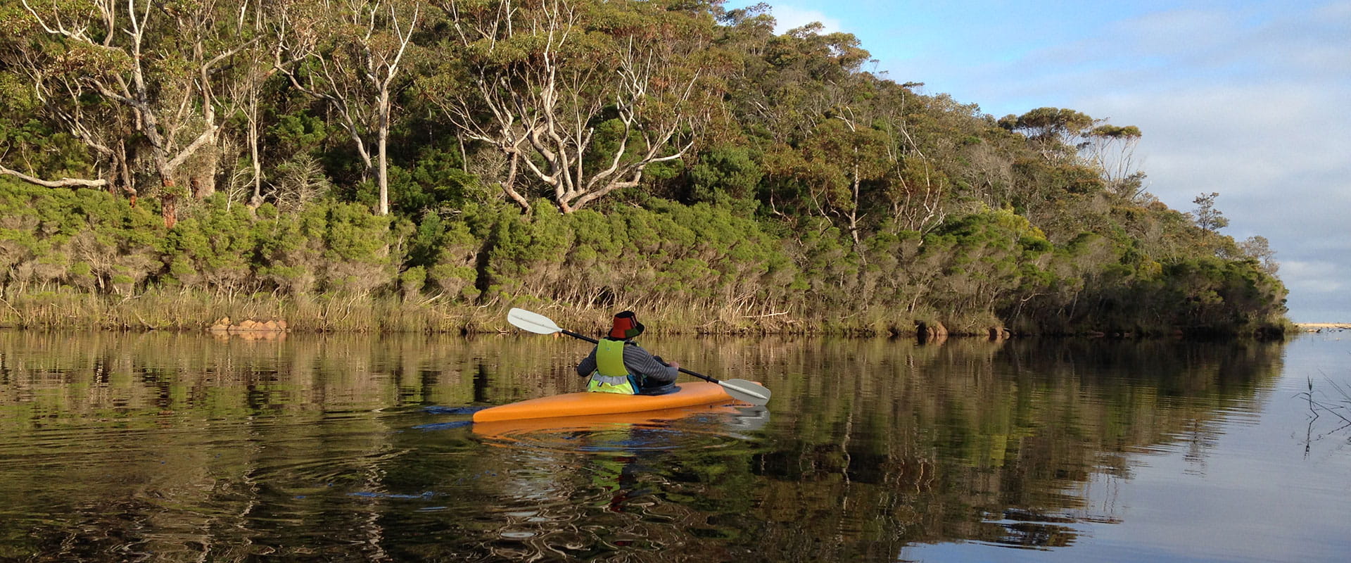
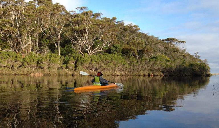
Branch out and paddle up the Wingan River in your trusty canoe or kayak. The river narrows upstream as it winds through sea rushes and paperbark thickets before opening on to a rainforest and the stunning Wingan Rapids. Here, crystal clear water trickles between gargantuan granite boulders decorated in a blanket of colourful lichen and moss. Curious water dragons peer out from behind wildflowers while native birds sing the day away.
While the Wingan Rapids are also accessible by foot, set out on the Fly Cove Walk for a change of scenery. Skirt the edge of Wingan Inlet, through paperbark forest before emerging on the lonely shores of Fly Cove. Take in the Southern Ocean vistas and admire the Australian and New Zealand Fur Seals that call the offshore rock stacks, known as The Skerries, home. One of only four Australian Fur Seal colonies in Victoria, and the largest, visit between October and December to see playful seal pups about.
Elusive Lake is another great wander from Wingan Inlet. The unique dune-blocked lake stands out among the tall eucalypts that surround its sandy banks. Reaching a depth of 22 metres in some places, jump in for a refreshing swim before returning to camp.
Things To Do
Wingan Inlet Campground
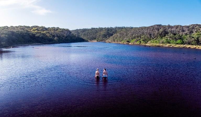
Elusive Lake
Canoeing and Kayaking
How to get there
Wingan Inlet
When you're there
When to go
Along with Mallacoota, Sydenham and Tamboon Inlet, Wingan Inlet provides excellent fishing opportunities and draws anglers from across the state year-round. Big schools of Black bream can be caught throughout the lake system between December and May. While in winter, salmon, tailor and trevally are common.
Need to know
Wingan Inlet
Accessibility
Wingan Inlet contains a number of campsites that are relatively flat set in clear, open areas. But note that there's a lack of accessible toilets and the trails leading down to Fly Cove are narrow and steep in some sections.
Assistance dogs are welcome in Parks Victoria parks and reserves. Entry requirements apply for parks and reserves that are usually dog prohibited, such as national parks.
Boating
If you're planning to fishing or boating in the water, please note that Wingan Inlet has a 20hp motor size limit.
Change of Conditions
Nature being nature, sometimes conditions can change at short notice. It’s a good idea to check this page ahead of your visit for any updates.
-
Allan Head (Croajingolong National Park)
Allan Head Jetty Closure
The Allan Head jetty is temporarily closed for public safety. Visitors are advised that the Allan Head day visitor area remains open, however access onto the jetty is restricted. -
Notices Affecting Multiple Sites
Tracks and areas closed in the Croajingolong National Park
The following areas are closed because of the 2019/2020 bushfires and coastal erosion caused by heavy rainfall. Parks Victoria continue to maintain surveillance and security of these areas as works continue to reinstate access.· Point Hicks Lightstation· Saros Track· Sledge TrackThe Wilderness Coast Walk is open all the way from Bemm River to Mallacoota. Staff have recently marked sections of the track however, combined flood and fire damage have made some areas more difficult to negotiate. Hikers must be able to self-navigate with a map and compass.The following walking track is closed:· Wingan Inlet Rapids WalkThe following jetties around Mallacoota are closed:· Kingfish Point. Goanna BayThe following tracks remain closed due to storm damage· Miners TrackPeachtree Creek Camp Closed for Upgrades - May / June 2026
Peach Tree Creek campground will be closed from April 30 2026 whilst upgrades to the campground are being completed.No access to the boat ramp, jetty or toilet block is possible.Works are expected to be completed by end of June 2026.Alternative access to Tamboon Inlet is available via the boat ramp at Furnell Landing, Tamboon Rd. See map here. -
Goanna Bay (Croajingolong National Park)
Goanna Bay Jetty Closure
The Goanna Bay Jetty is temporarily closed for public safety. Visitors are advised that the Goanna Bay day visitor area remains open, however access onto the jetty is restricted. -
Kingfish Point (Croajingolong National Park)
Kingfish Point Jetty Closure
The Kingfish Point Jetty is closed for public safety. Visitors are advised that the Kingfish Point day visitor area remains open. -
Notices Affecting Multiple Parks
Peachtree Creek Camp Closed for Upgrades - May / June 2026
Peachtree Creek Creek campground is closed from 30 April 2026 whilst upgrades are being completed.No access to the boat ramp, jetty or toilet block is possible whilst works are underway.Works are expected to be completed by end of June 2026.Alternative access to Tamboon Inlet is available via the boatramp at Furnell Landing at the end of Tamboon Rd. See here for map.Planned aerial shooting operations targeting deer
Control operations (aerial shooting) targeting deer are planned for this area. During operations parts of the Park will be closed to visitors. More information on closures will be posted a minimum of 4 weeks prior to commencement.Visitors are advised to check the Change of conditions listing prior to arrival for up to date information and maps.For more information about deer control to protect biodiversity, please visit this link.Ground shooting operations targeting deer
Control operations (ground shooting) targeting deer are undertaken in this area. The Park will remain open to visitors during operations.
For more information about deer control to protect biodiversity, please visit our Deer page.
-
Croajingolong National Park
Planned aerial shooting operations targeting deer
Control operations (aerial shooting) targeting deer are planned for this area. During operations parts of the Park will be closed to visitors.Partial closure of Croajingolong NP from June 9 - June 12 2026 (inclusive).Attachments: Information_CapeHowe_Aerial_9-12Jun (252KB)
-
Genoa Peak (Croajingolong National Park)
Genoa Peak Road and Walking Track Temporary Closure
Genoa Peak Road and Genoa Peak walking track will be temporarily closed from Tuesday the 2nd June 2026 to Tuesday the 2nd July 2026 to allow for hazardous tree treatment works and road maintenance and repairs.Genoa Peak Road and Walking Track closure
Genoa Peak Road and Genoa Peak Walking Track will be temporarily closed to public access from the 2nd June 20026 to the 2nd July 2026 to allow for hazardous tree treatment and road maintenance works.Genoa Peak Road -4WD only
The Genoa Peak Road is open to 4WD vehicles only and is NOT advised for 2WD vehicles.The road has had major flood damage resulting in wash outs and deep rutting.Genoa Peak Walking Track remains open. -
Mueller Camp (Croajingolong National Park)
Mueller Inlet Camp closed due to flooding
Mueller Inlet camp is closed due to flooding. The river inlet is currently shut and all sites and the carpark are flooded.Alternative camping is available nearby at Thurra River Camp.Rangers will monitor the flooding and update this page as soon as camping is available.