
Brambuk: The National Park and Cultural Centre, in Halls Gap began, with the building of the Brambuk Cultural Centre in 1989 to acknowledge, protect and share the cultures of the Jadawadjali and Djab Wurrung Peoples.
![]()
![]()
![]()
277 Grampians Road
Halls Gap VIC 3381
View map brambuk@parks.vic.gov.au
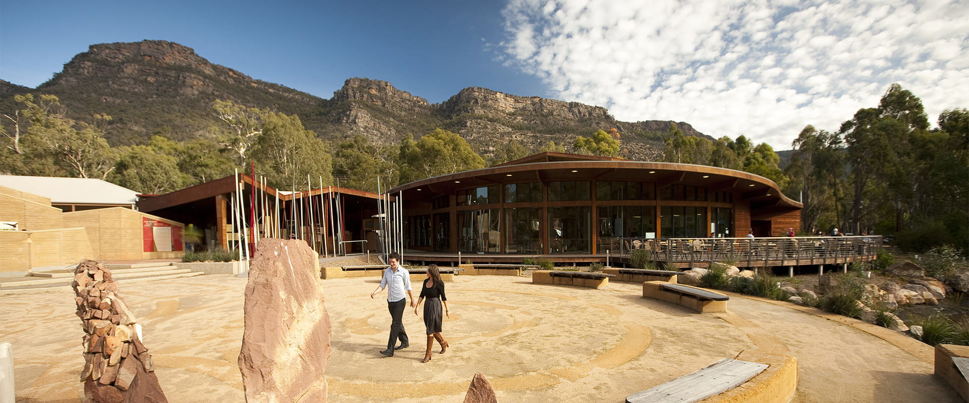
Make Brambuk the National Park and Cultural Centre in Halls Gap your first stop before exploring Grampians (Gariwerd) National Park.
Visit the National Park Information Centre where you can source the latest park information including walking, camping and touring. Knowledgeable park staff can help you discover famous hiking trails, beautiful waterfalls, spectacular mountain views and ancient Aboriginal rock art shelters. A unique range of local Indigenous products, Australian made souvenirs and park maps are available in the gift shop to help you enjoy your stay.
A series of self-guided and wheelchair friendly walks through the Brambuk wetlands and native gardens links the Park Information Centre to the Cultural Centre, and provides a glimpse of the native plants and animals of Gariwerd.
Since opening in 1990, Brambuk provides an opportunity for visitors to connect and learn about what Gariwerd means to the Jadawadjali and Djab Wurrung people. The award-winning Cultural Centre building is currently closed for upgrades, and these works are expected to be ongoing between 2022 and 2026. Find out more on our Brambuk Cultural Centre Upgrade project page.
Keep an eye on the Parks Victoria Junior Ranger website for the latest list of holiday activities and programs.
Brambuk is 2 km south of Halls Gap and is open 7 days a week (except Christmas Day) from 9 am to 4 pm or phone 8427 2058.
How to get there
Brambuk The National Park and Cultural Centre
Need to know
Brambuk The National Park and Cultural Centre
Accessibility
Visiting a park can be more of a challenge for people with disabilities, however in Victoria there are a wide range of facilities to help people of all abilities enjoy our wonderful parks around the state. Visit our All abilities access page to find more.
A Trailrider all-terrain wheelchair and Sherpa Volunteers are now available for park visitors with limited mobility to explore the natural beauty of Grampians National Park. The Grampians has two TrailRiders available for visitors and both of these chairs are fitted with electric motors to assist operators on steeper sections of track. Passengers must wear a helmet.
The TrailRider all-terrain wheelchair and Volunteer Sherpa service is free of charge, however, please book a week in advance. To book the TrailRider please contact the Volunteer Sherpa Coordinator on (03) 8427 3541 or volunteersherpa@parks.vic.gov.au
Change of Conditions
Nature being nature, sometimes conditions can change at short notice. It’s a good idea to check this page ahead of your visit for any updates.
-
The Fortress Walk (Victoria Range Remote and Natural Area, Grampians (Gariwerd) National Park)
The Fortress Walk and Hike-in Campground – Temporary closure
The Fortress Walk and The Fortress Hike-in Camp remain closed to visitors due to track damage from the 2024/25 summer bushfires.For more information on alternate walks in the western section of the Grampians (Gariwerd) National Park visit Brambuk the National Park and Cultural Centre in Halls Gap or call 03 8427 2058. -
The Chimney Pots Walk (Victoria Range Remote and Natural Area, Grampians (Gariwerd) National Park)
The Chimney Pots Walk – Temporary closure
The Chimney Pots Walk remains closed to visitors due to track damage from the 2024/25 summer bushfires.For more information on alternate walks in the western section of the Grampians (Gariwerd) National Park visit Brambuk the National Park and Cultural Centre in Halls Gap or call 03 8427 2058. -
Red Gum Walk (Grampians (Gariwerd) National Park)
Red Gum Walk – Temporary closure
The Red Gum Walk remains closed to visitors due to track damage from the 2024/25 summer bushfires.For more information on alternate walks in the western section of the Grampians (Gariwerd) National Park visit Brambuk the National Park and Cultural Centre in Halls Gap or call 03 8427 2058. -
Grampians (Gariwerd) National Park
Grampians (Gariwerd) National Park - Roads Update 17.07.2026
The Grampians (Gariwerd) National Park has roads temporarily closed due to bushfire and weather impacts.Please observe road closures, hazard signage and always drive to conditions.Seasonal Road Closures are now in place from the 9 June 2026 to 29 October 2026.Please refer to the attached up-to-date road report below.Attachments: Grampians (Gariwerd) National Park - Road Report 17.07.2026 (230KB)
Aerial pest animal control program in the Grampians (Gariwerd) National Park – 27 to 31 July 2026
Parks Victoria is conducting a conservation program to improve the health of the Grampians (Gariwerd) National Park, following the devastating 2024-25 summer bushfires, which impacted approximately 80% of the park.Action is being taken to reduce predators (foxes and feral cats) and introduced herbivores (deer and feral goats), threatening the survival and recovery of vulnerable native plants and animals.Weather permitting, an aerial control operation will be conducted from Monday 27 July to Friday 31 July 2026 to support ongoing conservation programs.To ensure visitor safety, warning signs will be placed at temporary closures and road access points to restrict access to the operational areas. Parks Victoria rangers will also be on the ground at key closures. Visitors are encouraged to follow instructions from staff and information on temporary signage.No additional closures of visitor sites or campgrounds are being implemented. This includes the Grampians Peaks Trail (GPT) and GPT Hike-in campgrounds. The GPT will be buffered out of the operations area.Please see attached Fact Sheet for further details of the Aerial pest animal control operation.For further information please contact Brambuk the National Park and Cultural Centre on 03 8427 2058.Attachments: Gariwerd Aerial Pest Animal Control Program July 2026 Fact Sheet (519KB)
Temporary closure of a Glenelg River Road section – 25 May to 7 August 2026
The section of Glenelg River Road from the Stony Creek Road intersection to the Boreang Campground turn off will be closed from Monday 25 May 2026 to Friday 7 August 2026 for roadworks.The southern end of the closure can be accessed via Rose Creek Road. Paddy Castle Walk and Boreang Campground remain open, as does Glenelg River Road, south of Lodge Road.For further information please contact Brambuk the National Park and Cultural Centre Phone 8427 2058. -
Strachans Campground (Grampians (Gariwerd) National Park)
Strachans Campground –Temporary Closure – 13 April – 30 July 2026
Strachans Campground will be closed to visitors between 13 April and 30 July 2026 while major upgrade works are completed.For further information contact Brambuk the National Park and Cultural Centre in Halls Gap (Ph 8427 2058). -
Mackenzie Falls Day Visitor Area (Grampians (Gariwerd) National Park)
Mackenzie Falls (Migunang wirab) - Upcoming closure for major construction works – 9 February 2026 to the end of 2026
This update is to provide information for the planned construction work at Mackenzie Falls in the Grampians (Gariwerd) National Park, and closures while the works happen.The works at Mackenzie Falls precinct includes the construction of a new viewing platform at the base of the falls, upgrades to the carpark and the Bluff Lookout Walk and other important safety improvements to stabilise rock and improve walking tracks.
The Mackenzie Falls carpark and all walking tracks in the precinct including Broken Falls Walk, Mackenzie Falls Walk to the base (from the carpark), the Bluff Lookout Walk, and parts of Mackenzie Falls River Walk will close when construction starts on Monday, 9 February, 2026, and we anticipate that construction work will finish by the end of 2026.The carpark will be a construction site throughout the works period with large machinery operating and materials being stored on site. There will be no access for all vehicles or visitors at Mackenzie Falls Precinct during construction.Zumsteins Picnic AreaWhen construction works start at Mackenzie Falls precinct, parking at the popular Zumstein picnic area will be limited, especially for large vehicles (buses and caravans) during weekends and holiday periods.Zumsteins to Fish Falls – This popular walk to the beautiful Fish Falls is a 1.5 to 2 hour return walk (Grade 3) – walkers should have a reasonable fitness level, carry water and wear sturdy walking shoes as the track can be rocky with uneven surfaces and some steep sections.Mackenzie River WalkFrom May 2026 until works are complete, the base of Mackenzie Falls will not be accessible via the Mackenzie River Walk from Zumsteins Picnic Area.
For further information on the Mackenzie Falls (Migunang wirab) project visit https://www.parks.vic.gov.au/projects/western-victoria/mackenzie-falls-revitalisation
Popular day visitor sites such as Reeds Lookout, the Balconies, Boroka Lookout, Silverband Falls and various walks with large bus carparking will still be available. For further information on the Mackenzie Falls River Walk contact Brambuk the National Park and Cultural Centre in Halls Gap (Ph 8427 2058).Please keep up to date with closures through the Change of Conditions page for Grampians (Gariwerd) National Park. -
Brambuk the National Park and Cultural Centre (Brambuk - The National Park and Cultural Centre Park, Grampians (Gariwerd) National Park)
Brambuk the National Park and Cultural Centre – Building Upgrades in 2026
The Cultural Centre is closed for refurbishment.Parks Victoria is working with a strategic partnership committee of Gariwerd Traditional Owners from Barengi Gadjin Land Council, Eastern Maar Aboriginal Corporation, and Gunditj Mirring Traditional Owners Aboriginal Corporation to ‘reimagine’ the future of Brambuk the National Park and Cultural Centre.Building upgrades are essential to ensure the centre meets current services requirements, accessibility, and compliance to current building regulation. New visitor experiences and activation opportunities including Aboriginal arts, community events and cultural exhibitions are being explored as Brambuk moves towards operation by a Gariwerd Traditional Owner entity.The National Park Information Centre and gift shop remain open.For up-to-date national park information, brochures, maps, permits and access advice contact information staff at Brambuk the National Park and Cultural Centre info@parks.vic.gov.au or phone 8427 2058For Junior Ranger School holiday programs visit https://www.parks.vic.gov.au/things-to-do/junior-rangersFor a list of Grampians (Gariwerd) National Park Licensed Tour Operators Visit https://www.parks.vic.gov.au/ltoFurther details on the Brambuk Reimagining project can be found on the Parks Victoria website https://www.parks.vic.gov.au/projects/western-victoria/brambuk-cultural-centre-upgrade