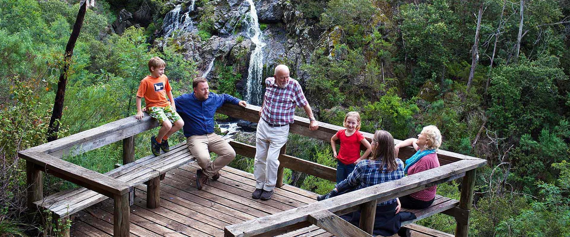
Nestled in the north of Alpine National Park, and bordering Kosciuszko National Park, the wild and remote Benambra, Buchan and Bonang area is Victoria’s modern world escape. Explore the magnificent Snowy River, picturesque Suggan Buggan Valley, the headwaters of the Murray River, and spectacular peaks of Mount Cobberas and Tingaringy.
Taking in the quaint hamlets of Bonang, Tubbut and Suggan Buggan, this remote corner of the Alpine National Park is an adventure-lovers dream. Journey along Limestone Road or McKillops Road to access its wild peaks and valleys. Or if you’re a seasoned four-wheel driver, venture deep into the wilderness along the Davies Plain Iconic Drive.
For experienced bushwalkers, take on scenic hikes to the peaks of Mount Stradbroke, Mount Cobberas, Cowombat Flat or Tingaringy Falls, and when you’re done for the day, pitch a tent in the remote Native Dog Flat, Willis or McKillop Bridge Camping Areas.
If you’re not strapped for time, trek the extraordinary 650-kilometre Australian Alps Walking Trail. The walk meanders from Walhalla through Baw Baw and the Alpine National Park, before crossing into New South Wales and concluding its journey in Canberra.
Enjoy a day out on the rapids of the Snowy River for an unforgettable experience. Launch your canoe, kayak or raft from Willis Camping Area or the historic McKillop Bridge. The heritage-listed bridge was built in the 1930s to allow vehicles, and more importantly livestock, safe passage across a spectacular gorge that the Snowy River has carved.
Things to do in the area
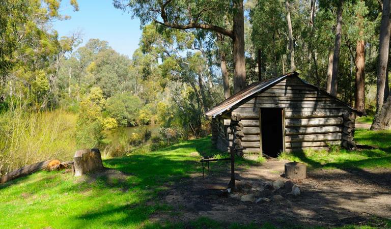
Kennedys Hut
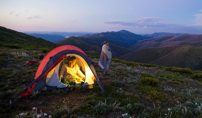
Dispersed camping in Alpine National Park
How to get there
Benambra, Buchan and Bonang
This part of the Alpine National Park adjoins Kosciuszko National Park along its northern boundary and the Snowy River National Park to the south.
The park is between 440 and 500 km north-east of Melbourne. The main access roads are all unsealed, narrow and winding and generally unsuitable for caravans.
The Snowy River Road accesses the Snowy River at Willis on the state border. This road becomes the Barry Way across the border and passes through Kosciuszko National Park en route to Jindabyne.
The Bonang Road from Orbost is an alternative approach - McKillop Road branches from it a few kilometres south of Bonang.
The Limestone-Black Mountain Road crosses the central part of the park and links Benambra to the Snowy River Road. This road is often closed in winter as a result of heavy snowfalls.
Facilities
When you're there
Download the Benambra, Buchan and Boang visitor guide for more information about the park and the plethora of experiences to be had within its borders.
When to go
Need to know
Benambra, Buchan and Bonang
Accessibility
Visiting a park can be more of a challenge for people with disabilities, however in Victoria there are a wide range of facilities to help people of all abilities enjoy our wonderful parks around the state.
Assistance dogs are welcome in Parks Victoria parks and reserves. Entry requirements apply for parks and reserves that are usually dog prohibited, such as national parks.
Change of Conditions
Nature being nature, sometimes conditions can change at short notice. It’s a good idea to check this page ahead of your visit for any updates.
-
Alpine National Park
TRACK CLOSURE: Little Cobbler Track, Alpine National Park
Due to the poor condition of the Little Cobbler Track, it is closed. The track has suffered significant impacts from multiple flood and storm events that has left deep ruts that are not trafficable, making use of the track unsafe.There are multiple 4WD options for alternate routes between Lake Cobbler Road and Speculation Road areas. Options include;- via Cobbler Lake Track. Turn off Lake Cobbler Rd onto Cobbler Lake Track thru to Speculation Road.
- via Wild Horse Gap Track. Turn off Lake Cobbler Rd onto Wild Horse Gap Track, turn onto Burnt Top Track and follow thru to Pineapple Flat. From Pineapple Flat take King Basin Road thru to Speculation Road.
- via Basin Track. Turn off Upper Rose River Rd onto Basin Track, turn onto Burnt Top Track and follow thru to Pineapple Flat. From Pineapple Flat take King Basin Road thru to Speculation Road.
Please contact Parks Victoria on 13 19 63 if you need further assistance with journey planning in this area to assist with navigating around this closure.Cobberas, Ingeegoodbee and Macfarlane Flat Track closures.
The following tracks have been significantly damaged by storms and floods and are currently closed to motor vehicles to ensure public safety and environmental protection:- Cobberas Track
- Macfarlane Flat Track
- Ingeegoodbee Track
The tracks are likely to remain closed to motor vehicles until detailed site assessments have been completed. It is difficult to predict when planning approvals will be obtained to allow for repairs to commence.
Before visiting, visitors should check the Parks Victoria website for the latest information about their destination.Attachments: FAQs for Cobberas ingeegoodbee and mcfarlane tks (128KB)
-
Notices Affecting Multiple Sites
The Alpine National Park is CLOSED east of Mt Speculation, South and West of Mt Selwyn – due to the Dargo Wonnangatta complex fires in the area.
Closed sites/tracks include:- East Buffalo Road and West Buffalo Track
- Australian Alps Walking Track east of Mt Speculation and west of Mt Selwyn including the Razor Viking and Barry Mountains sections
- Mount Selwyn Road and Selwyn Creek Road south of its intersection with Twins Jeep Track
- Rileys Track, Humffray River Track, Whites Track & Water Spur Track
Open areas:- Walking tracks between Falls Creek and Mt Hotham
- Mt Buffalo
- Howqua Hills
- Australian Alps Walking Track north to Camp Creek including the Crosscut Saw and Mt Speculation
- King Hut
- King Billy Track through to Howitt Road
- Lake Cobbler
Changes to Previous ClosuresReopening of areas along Cobbler Lake, Speculation Rd, Abbeyard Rd, Dargo High Plains road sites to the east, Crosscut and Speculation, Lake Cobbler area, King Hut, King Billy trackStay informed- For updated information, visit the VicEmergency website, or call the hotline on 1800 226 226.
- Download the VicEmergency app and know how to use it – create a watch zone for your home, work and loved ones to receive alerts within that watch zone.
- Know your local emergency broadcaster and never rely on one source of emergency information.
- Visit the CFA website for the latest information on Fire Danger Ratings.
- Visit the BOM website to stay updated on weather forecasts and warnings.
The Alpine National Park is CLOSED north of Briagolong, east of Arbuckle Junction including Mount Howitt to Wabonga and south of Abbeyard, west of the Great Alpine Road and to the west of Dargo – due to the Dargo Wonnangatta complex fires in the area
Closed sites:- Howitt Road, Moroka Road, Tamboritha Road after Lost Plain- King Billy Track- Wonnangatta Valley including the Icon Drive from all approaches into the Valley- Mount Howitt carpark, Vallejo Gantner Hut, Macalister Springs and Mount Howitt Walking Track- Australian Alps Walking Track within the closure area- McMillans walking track within the closure area- Bicentennial trail within the closure area- Howitt Hut- Bryces Gorge camping area- Moroka Road and Pinnacles Day visitor area, Horseyard Flat camping area, Mcfarlanes Saddle, Moroka Hut- Billy Goat Bluff Track- Blue Rag Range Track- All other roads and tracks in the closed areas of the Alpine National Park- Grant Historic Area, including Eaglevale and Talbotville campsites- Mount Sarah Natural Features and Scenic ReserveOpen areas
Open areas include:- Wellington Campsites on Tamboritha Road- Wellington River Trailhead to Lake Tali Karng (the only access to Lake Tali Karng, Mcfarlanes Saddle closed)- Thomastown Camping area, Kelly Hut, McMichaels Hut- King Spur Track into Mayford- Alpine National Park beyond Hotham Heights to the north and to Omeo- Avon Wilderness ParkStay informed- For
updated information, visit the VicEmergency
website, or call the hotline on 1800 226 226.
- Download
the VicEmergency app and know how to use it – create a watch zone for
your home, work and loved ones to receive alerts within that watch zone.
- Know
your local emergency broadcaster and never rely on one source of emergency
information.
- Visit
the CFA website for the latest information on Fire
Danger Ratings.
- Visit
the BOM website to stay updated on weather forecasts
and warnings.
Attachments: 20260129_1600_Forest_Park_Closures_A0P (12,358KB)
-
Notices Affecting Multiple Parks
Ground shooting operations targeting deer
Control operations (ground shooting) targeting deer are undertaken in this area. The Park will remain open to visitors during operations.Planned aerial shooting operations targeting deer
Control operations (aerial shooting) targeting deer are planned for this area. During operations parts of the Park will be closed to visitors. More information on closures will be posted a minimum of 4 weeks prior to commencement.Visitors are advised to check the Change of conditions listing prior to arrival for up to date information and maps.For more information about deer control to protect biodiversity, please visit this link.