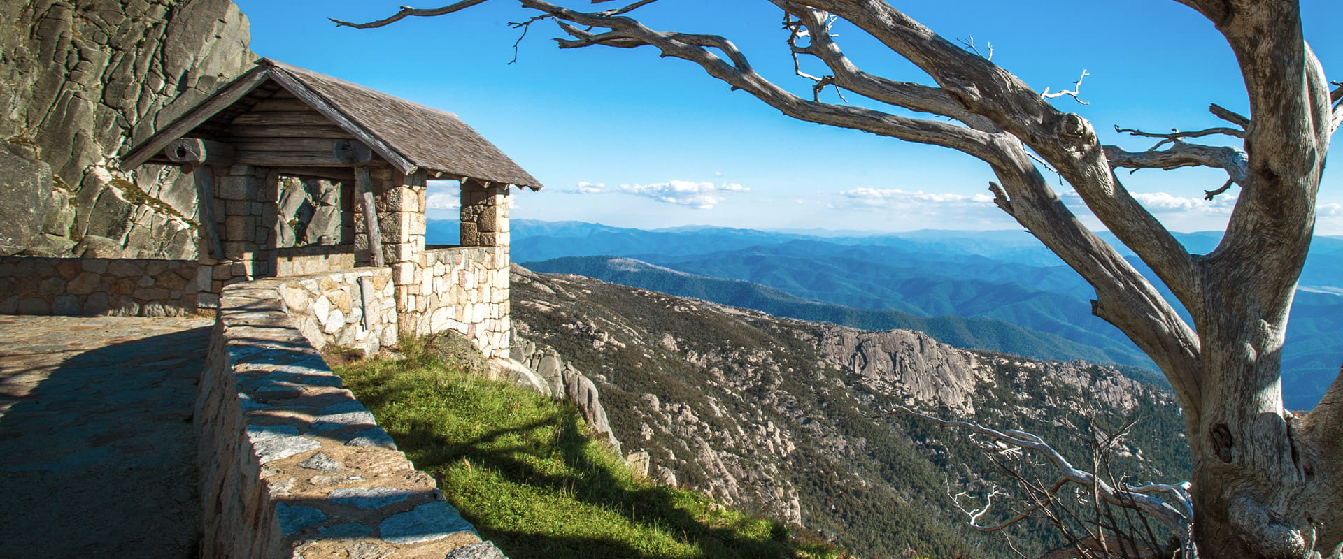
Enjoy a picnic with a view at The Horn before climbing to the highest point in Mount Buffalo National Park and surveying the folded mountains of the Great Dividing Range stretching into the distance. The Horn is the perfect place to enjoy a sunset or sunrise within an easy drive of the beautiful Alpine town of Bright.
Perched on top of granite cliffs at the edge of the Mount Buffalo plateau, The Horn is a unique landscape. Dotted here and there among the great boulders are the twisted, sun-bleached trunks of Snow Gums that have succumbed to bushfires over the years. A stone lookout shelter perched precariously atop the cliff overlooks all of this as well as the surrounding mountains far below.
Bring your lunch and enjoy the Alpine scene from the comfort of a table at The Horn Picnic Area. The picnic area isn't actually at the top of The Horn. You can access the summit via a short walk (45 minutes return).
This is also a popular place to watch a sunset. If you're lucky you might see little Australian Kestrels diving on Bogong Moths in the failing light. Otherwise, just enjoy the solitude of this mountain peak far above the worries of civilisation.
Things to do
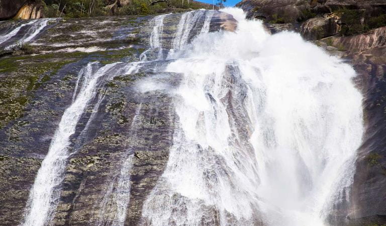
Ladies Bath and Eurobin Falls
At Ladies Bath Falls, water cascades into a perfectly clear pool of water, while at Upper and Lower Eurobin Falls, Crystal Creek spills spectacularly over a formidable granite escarpment.
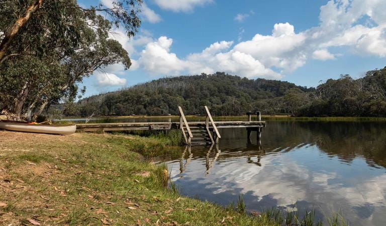
Lake Catani Campground
Discover magnificent waterfalls and remote alpine landscapes while camping within beautiful Snow Gum woodlands beside Lake Catani in Mount Buffalo National Park.
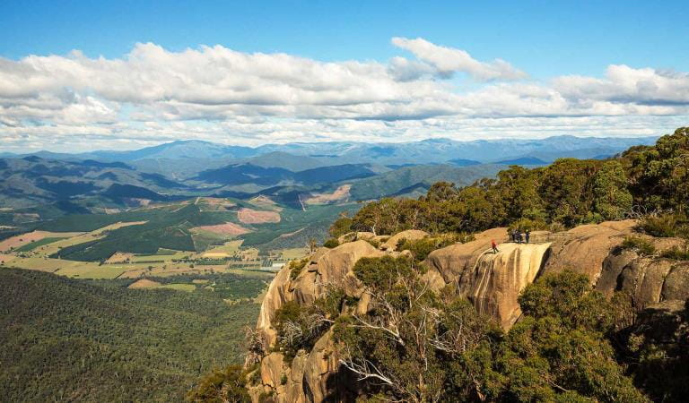
The Gorge and Mount Buffalo Chalet
Home to historic Mount Buffalo Chalet, the Gorge is perched on 200m sheer cliffs and commands fantastic views over the Alps.
How to get there
The Horn
Mount Buffalo is 325 kilometres (three and a half hours’ drive) northeast from Melbourne along the Hume Highway. Either take the Snow Road exit just before Wangaratta or continue along the highway to the Great Alpine Road (B500) exit. Watch out for native animals, especially early in the morning and at dusk. Take care driving during winter. The main road is often snow covered from McKinnons Corner through to Cresta Valley. Snow chains must be carried and fitted when and where directed by road signs during the declared snow season. Horn Road is unsealed and can become dusty and rough. It is closed during winter or following periods of heavy rain. Horn Road is not suitable for caravans.
When you're there
The Horn Picnic Area is located just below The Horn which is the highest point of Mount Buffalo at 1,723 metres. The views from the picnic area are superb, but a walk along the Horn Track, which starts from here, will take you to another lookout with 360 degree views of the plateau and Australian Alps. The trail is 800m or 45 minutes return. The nearest toilets to the Horn Picnic Area are located at Cathedral Saddle.
Need to know
The Horn
Accessibility
Visiting a park can be more of a challenge for people with disabilities, however in Victoria there are a wide range of facilities to help people of all abilities enjoy our wonderful parks around the state.
Assistance dogs are welcome in Parks Victoria parks and reserves. Entry requirements apply for parks and reserves that are usually dog prohibited, such as national parks.
Change of Conditions
Nature being nature, sometimes conditions can change at short notice. It’s a good idea to check this page ahead of your visit for any updates.
-
Notices Affecting Multiple Sites
Horn Road Seasonal Closure
The Horn Road is subject to seasonal road closure from the Thursday after the Kings Birthday long weekend to September 15th inclusive.Seasonal Road Closure - Reservoir Road, Mt Buffalo NP
Reservoir Road is subject to seasonal road closure from the Thursday after the Kings Birthday long weekend to the Thursday before the Melbourne Cup long weekend inclusive.
-
Lakeside Day Visitor Area (Mount Buffalo National Park)
Lake Catani Road Seasonal Closure
Lake Catani Road is subject to seasonal closure from the Thursday after the Kings Birthday long weekend to September 15 inclusive.Lake Catani campground is open for walk-in camping only, no bookings required.