Williamstown Wave Wash and Surge Study Project
Project status
April 2024
Expanded five 5-knot speed restriction zone
Parks Victoria is pleased to announce a final decision has been made by Safe Transport Victoria to adopt the 5-knot rule change within the waterways in the Williamstown Maritime precinct.
This permanent rule change will come into effect from 30 April 2024.
The rule change extends the 5-knot zone to all the waters southwest of the Williamstown Commercial Shipping Channel from Warmies boat ramp to Gellibrand Pier.
.jpg?h=637&w=900&rev=b50935cb61a4433cb9769271c27fc7ad&hash=9E1C5A6C7EAEA7E1920DBCC8EF1A94F7)
Above: Map of Williamstown 5-knot zone
The waterway rule change delivers a key recommendation from this study completed in 2022 into the cause of the wave, wash and surge issues experienced by the local boating community. The adoption of this 5-knot zone is a measure to reduce the generation of wake within the waters between the shipping channel and the shoreline of the Williamstown Maritime Precinct, as well as making it easier for boaters to understand where the 5-knot zone applies.
Feedback captured through community consultation, alongside engagement with key authorities and stakeholders, has been used to inform this decision being made by Safe Transport Victoria.
A new 5-knot speed restriction zone will take effect from 30 April 2024. The zone is gazetted by Safe Transport Victoria at the request of Parks Victoria, it will span the waters between the southwestern boundary of the Newport Warmies breakwater, Williamstown foreshore, to Ann St Pier, and is bound by the Port of Melbourne shipping channel and an adjacent Ports Victoria new 5-knot zone. refer Victorian Notice to Mariners
Mariners are advised to navigate at a speed of 5 knots or less within the new Williamstown zone, unless operating in accordance with the exemption for vessels under sail and sea planes.
The study is now complete and key findings have been presented to the project’s stakeholder reference group. The reports are available below.
Key findings documents:
Summary Report on the Williamstown Maritime Precinct Wave Wash and Surge Study
Stage 2 - Data Analysis Report for Williamstown Wave Wash Surge Study
Stage 3 - Mitigation Options Report for Williamstown Wave Wash Surge Study
Background
The Williamstown area of Hobsons Bay is home to many recreational, commercial and community boating activities and has well established infrastructure to support these activities. Located near the entrance of one of the busiest commercial ports in Australia, Port of Melbourne, there is significant maritime traffic entering and leaving the Yarra River and the adjacent Webb Dock Area.
In recent years there have been developing concerns raised about the effects of increased and often unexpected wave, wake, wash and surge on vessels. In response, Parks Victoria undertook a detailed Wave Study to identify and categories ‘wave, wash and surge’ events intermittently experienced and reported by stakeholders within the Williamstown Maritime Precinct.
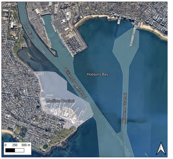
Above – Map showing the location of the Williamstown maritime precinct and nearby navigation channels. Credit: BMT.
The Project
The aim of the study was to better understand the occurrence, cause and impact of wave, wash and surge activity in the Williamstown Maritime Precinct and to develop high level options for future strategies to manage ‘wave, wash and surge’. The wave study collected data over a four-month period with data collected through a variety of methods to ensure the outcome provided a comprehensive picture of the issue. Radar water sensors, boat motion sensors, pressure sensors, and cameras were employed, and the project was carried out in three stages:- Stage 1 – Data Collection
- Stage 2 – Data Analysis
- Stage 3 – Modelling potential Mitigation Options
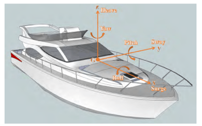
Above - illustrative representation of a boat's range of motion (left) and boat motion during a 'surge' motion (right). Credit: BMT.
Project timeline
- Project commencement and contractor appointed – December 2019
- Stage 1 – Data collection. Late 2020-early 2021 (Stage 1 experienced delays due to COVID-19 lockdowns which impacted data collection activities)
- Stage 2 – Data analysis. Early 2021 - Mid 2021
- Stage 3 – Modelling potential mitigations. Early 2022 – Late 2022
- Project completion – Feb 2023
Project partner and funding
This study was undertaken by Parks Victoria supported through funding from the Victorian Government via the Department of Transport and Planning.
Stay updated
For regular project updates, please subscribe for Williamstown Local Port Area Plan news.
For general enquiries email engage@parks.vic.gov.au or call us on 13 1963.
Related information
Parks Victoria is the local port manager for Port Phillip, Western Port and Port Campbell. The three local ports combined receive approximately 30 million visits a year, and include 263,000 hectares of waterway, marine protected areas, channels, piers and jetties, moorings and aids to navigation.
- Places to visit – Williamstown Piers
- Learn more about the Williamstown Local Port Area Plan project
FAQs
Will the mitigation strategies identified in the Study be implemented?
The study modelled several possible options to mitigate surge events and manage their associated issues. The study will continue to be used to better understand the issues occurring in the Williamstown maritime area and for future consideration. The findings were also considered as part of developing the Williamstown Local Port Area Plan, specifically exploring the modification or extension of the 5-knot zone.
Parks Victoria has shared the results with Ports Victoria to identify issues that are under the jurisdiction of the commercial port for consideration.
The speed restriction zone is established under Section 184 (1A)(a) of the Marine Safety Act 2010 and will amend the Vessel Operating & Zoning Rules for Victorian Waters (VOZR) collection of notices, introducing clauses 1.5.7(b) and 1.5.13(b) to Schedule 1.
1.5.7 Five (5) knot speed restriction zones
All waters of North West Port Phillip unless designated as a 5 knot zone below are subject to a 5 knot speed restriction within 200 metres of the water’s edge, excluding areas prohibited to vessels.
(b) Williamstown Maritime Precinct
The waters bound by the Williamstown foreshore and Port of Melbourne waters, from the end of Sandy Point Breakwater 2 (37° 51.106’ S, 144° 54.332’ E) to a point (37° 51.113’ S, 144° 54.418’ E) approximately 10 metres west of No. 24 port lateral pile, then south easterly to a point (37° 51.386’ S, 144° 54.679’ E) approximately 600 metres off the head of Boyd Pier at the Port waters of the Port of Melbourne port limits then south-west to the head of Boyd Pier (37°51.685' S 144°54.519' E), then easterly to Anne Street Pier at the Port waters of the Port of Melbourne port limits, then following the western side of the Anne Street Pier through to the shoreline.
1.5.13 Exclusive use and special purpose areas
(b) Williamstown Maritime Precinct - control of vessels
The following vessels are exempt from the provisions of clause 1.5.7(b) of this Notice, and a master of these vessels must not exceed 5 knots within 200 metres of the Williamstown foreshore:
(i) Sea planes
(ii) Vessels under sail
The Parks Victoria rule change is adjacent and complimentary to the Ports Victoria 5 knot amendment that will also come in to affect at the same time. Details of the Ports Victoria rule can be found in Schedule 2 of the Vessel Operating & Zoning Rules for Victorian Waters (VOZR).
As the local port manager and waterway manager, Parks Victoria can apply for rules to be made for waters under its control. The decision-making power to make a requested waterway rule change lies with the Safety Director, Safe Transport Victoria. To propose or amend a permanent waterway rule Parks Victoria must follow the defined process outlined in the Marine Safety Act 2010. Amongst several steps, public consultation must be completed before an application to make a rule change is submitted to the Safety Director. The application must consider feedback received and demonstrate how the rule will minimise risks, any alternative ways to address the matter and the expected benefits and costs of the proposed rule. The Safety Director will consider the application and make a determination regarding if the rule change will be made or not. Learn more about the process here
How will the extension to the 5-knot zone be enforced?
Safe Transport Victoria has legislated the rule making it an offence to exceed 5-knots in the zoned areas enabling Water Police and Transport Safety Officers (including Parks Victoria authorised officers) to issue warnings or infringements. Appropriate information will be provided such as signs at the Warmies boat ramp, on the Parks Victoria and Marine Safety Victoria websites and Notice to Mariners issued to inform users.
What is the Williamstown Wave, Wash and Surge Study?
The purpose of the Study was to identify the cause of the ‘wave, wash and surge’ issues that have been anecdotally reported and recorded in the Williamstown maritime area by the local boating community and to prepare potential options for future mitigation.
Funding to undertake the Study was provided through the Department of Transport and Planning (DTP) to Parks Victoria as the local port manager.
As part of the project, a Stakeholder reference group (SRG) was established. The SRG met at key project milestones to inform the project delivery. The group included representatives from organisations including the Boating Industry Association of Victoria, Department of Transport and Planning, Hobsons Bay Yacht Club, Port of Melbourne, Transport Safety Victoria, Ports Victoria, and the Royal Yacht Club of Victoria.
What is the outcome of the Study?
The study has identified and confirmed the occurrence of wave and surge events in Williamstown’s maritime precinct and has proposed several possible mitigation measures for future consideration. The Study will be used to inform the Government on the issues raised by local stakeholders and its findings considered in other planning processes including the Williamstown Precinct Plan Framework (prepared by DTP) and the Williamstown Local Port Area Plan (2023).
Will the mitigation strategies identified in the Study be implemented?
The study has modelled several possible options to mitigate surge events and manage their associated issues. The study will be used to better understand the issues occurring in the Williamstown maritime area and for future consideration. The findings will be also considered as part of the process to develop the Williamstown Local Port Area Plan, specifically exploring the modification or extension of the 5-knot zone.
Parks Victoria has shared the results with Ports Victoria to identify issues that are under the jurisdiction of the commercial port for consideration. Currently there is no funding commitment to implement the recommended mitigation actions, however Parks Victoria will review the feasibility and cost benefit to then seek funding that includes performance monitoring.
The findings from the Study will be considered as part of the research undertaken during the development of the local port area plan. The local port area plan provides a future-ready vision for the area’s on water assets and is intended to improve the function and sustainability of the Williamstown local port area, while protecting its values as a regional maritime and boating destination.
What is a local port area plan?
The Sustainable Local Ports Framework introduces the concept of a local port area plan. The aim of a local port area plan is to address current and future uses and development of the local port and is informed by technical investigations and stakeholder consultation.