Explore
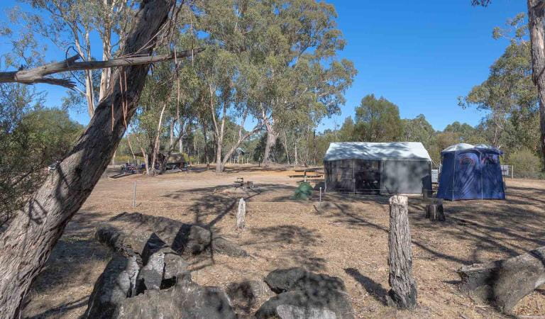
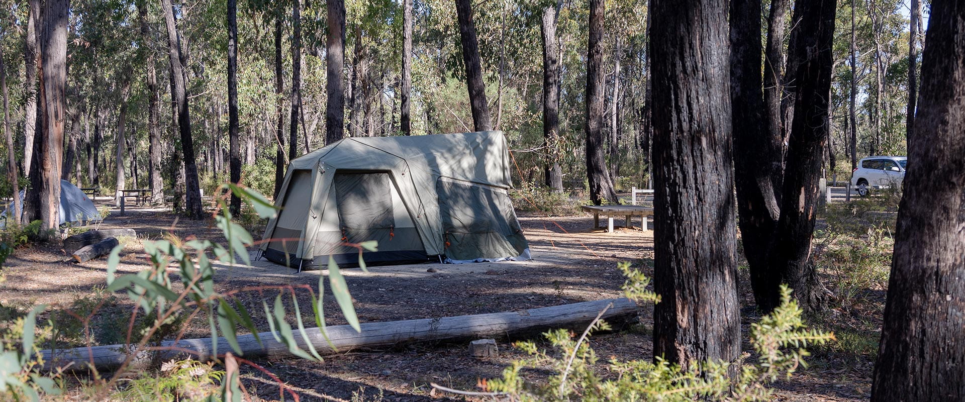
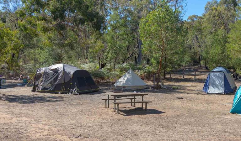
Smiths Mill Campground
Just 1km from popular sights such as Mackenzie Falls, and only a short drive to Boroka Lookout, Reeds Lookout and Zumsteins Picnic Area, Smiths Mill is the ideal campground to explore the central Grampians.
Smiths Mill Campground is located in woodland at the site of an old sawmill. Enjoy sleeping in the company of emus and kangaroos far from civilisation.
There are 28 sites suitable for tent-based camping with adjacent vehicle parking and five drive-in sites suitable for camper-trailers, caravans and campervans. Each site at Smiths Mill Campground accommodates a maximum of 6 people. Sites are unpowered.
There are non-flush toilets, a bush shower, and shared fire pits available.
Popular nearby sights include Mackenzie Falls, Boroka Lookout, Reeds Lookout and Zumsteins Picnic Area.
Things to do
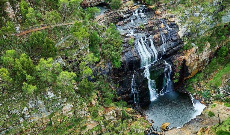
Mackenzie Falls
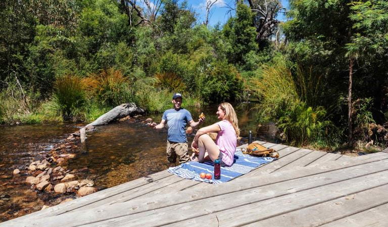
Zumsteins Historic Area
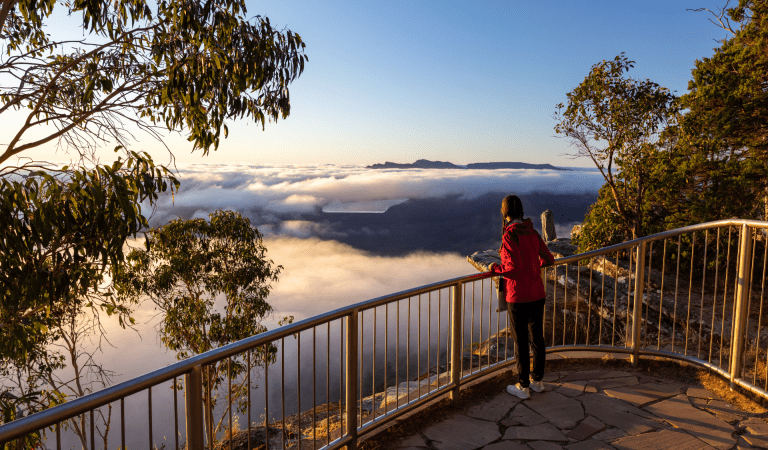
Boroka Lookout
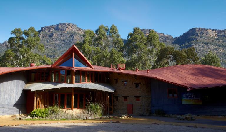
Brambuk The National Park and Culture Centre
How to get there
Smiths Mill Campground
Sites
When you're there
There is no supplied drinking water — limited non-potable water may be available from a seasonal rainwater tank and a river-fed campground taps. Bring your own firewood and keep fires in designated fireplaces.
Download the Grampians National Park visitor guide to get the most out of your park visit.
Need to know
Smiths Mill Campground
Safety tips for a great visit
Stay safe and get the most out of your park visit by preparing for natural hazards and other outdoor risks in Victoria’s parks. You are responsible for your own safety and the safety of those in your care.
Accessibility
Visiting a park can be more of a challenge for people with disabilities, however in Victoria there are a wide range of facilities to help people of all abilities enjoy our wonderful parks around the state.
Bushfire awareness
Smiths Mill Campground in the Grampians National Park is in the Wimmera fire district. Bushfire safety is a personal responsibility. Anyone entering the park during the bushfire season needs to stay aware of forecast weather conditions. Check the Fire Danger Rating and for days of Total Fire Ban at emergency.vic.gov.au, on the Vic Emergency App or call the Vic Emergency Hotline 1800 226 226.
No fires may be lit on Total Fire Ban days. On Catastrophic Fire Danger Rating days this park will be closed for public safety. Closure signs will be erected but do not expect an official warning.
Change of Conditions
Nature being nature, sometimes conditions can change at short notice. It’s a good idea to check this page ahead of your visit for any updates.
-
Grampians (Gariwerd) National Park
Rockclimbing Access Changes - Centurion Walls, Tortoise Wall
Re-discovery of cultural heritage at two designated rock-climbing sites in Grampians (Gariwerd) National Park has resulted in changes to access.Centurion WallsSignificant Aboriginal cultural values were rediscovered at Lower Centurion in late 2025. As a result, a partial closure is now in place, ensuring cultural heritage protection while maintaining modified climbing access for visitors. On-ground signage at the access track clearly delineates where climbing is or isn’t permitted.Visitors are advised:- Access is closed from the
area north of and including Damage Done. These sites include:
Damage Done, Shades of Black, Liberator, Lexicon, Temuujin, Killer Wolf, Devilled Haircut, Compressor route, Anti-Christ Superstar, Pining for the Fiords, Unknown Route 2, Genghis Khan, Project KP2, Project KP, Kublai Khan, Stone Temptress, Psychotic Episode, Trail of the dead, Flood the Zone, Push it Upstairs, Progressive Happy House.
- All climbs south of and
including In Plain Sight remain open. These climbs include; In Plain Sight, Who
Dreams of Cats, Who Dreams of Cats – short, Nowhere to Hide,
Afterworld, Left Hand Black, Centrifugal Force, Centrifugal Force –
Romanes Eunt Domas (linkup), Romanes Eunt Domas, Black Nobility, Sandpit,
Ton Steine Scherben, Winged Corpse, HCP, Massacres and Maniacs, Lunchbox
Legend, and AA New Rope / New route.
- Access to Upper Centurion
remains unchanged and is via the south end near Winged Corpse.
Tortoise WallWe’re currently asking visitors to not access the area known as ‘Tortoise Wall’ to avoid causing potential harm to Aboriginal cultural heritage that was rediscovered in April 2026. A temporary closure is now in place, while Parks Victoria and Gariwerd Traditional Owners determine a longer-term management response. Out of respect for this significant cultural landscape, visitors are requested to not access this area.For further information visit the 'rock climbing in Gariwerd' web page https://www.parks.vic.gov.au/places-to-see/parks/grampians-national-park/rock-climbing-in-gariwerdTemporary closure of a Glenelg River Road section – 25 May to 26 June 2026
The section of Glenelg River Road from the Stony Creek Road intersection to the Boreang Campground turn off will be closed from Monday 25 May 2026 to Friday 26 June 2026 for roadworks.The southern end of the closure can be accessed via Rose Creek Road. Paddy Castle walk and Boreang Campground remain open, as does Glenelg River Road, south of Lodge Road.Mount Victory Road will have an increased amount of heavy trucks and machinery. Drivers are urged to slow down and drive with care, particularly in tight corners.Please refer to the map provided for detour information. For further information please contact Brambuk the National Park and Cultural Centre Phone 8427 2058.
Grampians (Gariwerd) National Park - Roads Update 19.06.2026
The Grampians (Gariwerd) National Park has roads temporarily closed due to bushfire and weather impacts.Please be aware the movement of visitors in parts of the National Park is restricted.Due to recent weather our road/track network is wet and slippery. Please drive with extra caution across the Grampians (Gariwerd) National Park.Seasonal Road Closures are now in place from the 9 June 2026 to 29 October 2026.Ongoing RoadworksGlenelg River RdThe section of Glenelg River Road from the Stony Creek Road intersection to the Boreang Campground turn off will be closed until Friday 26 June 2026 for roadworks.The southern end of the closure can be accessed via Rose Creek Road then Phillip Island Track. Paddy Castle walk and Boreang Campground remain open, as does Glenelg River Road, south of Lodge Road.Recent OpeningsMitchell RdRecent ClosuresLodge Rd – from Glenelg River Rd to Red Rock Rd.Rose Creek Rd – from Phillip Island Track to Lodge RoadMt Difficult Loop Rd – from Lake Wartook carpark to Lake Wartook Lookout carpark.Boreang Campground can be accessed via Glenelg River Rd (4WD drive only from Lodge Rd intersection or Phillip Island Track).For more detail, please refer to the attached up-to-date road report attached.Attachments: Grampians (Gariwerd) National Park - Road Report 19.06.2026 (241KB)
- Access is closed from the
area north of and including Damage Done. These sites include:
-
Billimina Walk (Grampians (Gariwerd) National Park)
Billimina Walk – Temporary closure
Billimina Walk and Rock Art Shelter remain closed to visitors due to track damage from the 2024/25 summer bushfires.An alternative walk in this area is the Manja Walk to the Manja Shelter, which is an Aboriginal Rock Art site in the Victoria Range.For more information visit Brambuk the National Park and Cultural Centre in Halls Gap or call 03 8427 2058. -
The Fortress Walk (Victoria Range Remote and Natural Area, Grampians (Gariwerd) National Park)
The Fortress Walk and Hike-in Campground – Temporary closure
The Fortress Walk and The Fortress Hike-in Camp remain closed to visitors due to track damage from the 2024/25 summer bushfires.For more information on alternate walks in the western section of the Grampians (Gariwerd) National Park visit Brambuk the National Park and Cultural Centre in Halls Gap or call 03 8427 2058. -
The Chimney Pots Walk (Grampians (Gariwerd) National Park, Victoria Range Remote and Natural Area)
The Chimney Pots Walk – Temporary closure
The Chimney Pots Walk remains closed to visitors due to track damage from the 2024/25 summer bushfires.For more information on alternate walks in the western section of the Grampians (Gariwerd) National Park visit Brambuk the National Park and Cultural Centre in Halls Gap or call 03 8427 2058. -
Red Gum Walk (Grampians (Gariwerd) National Park)
Red Gum Walk – Temporary closure
The Red Gum Walk remains closed to visitors due to track damage from the 2024/25 summer bushfires.For more information on alternate walks in the western section of the Grampians (Gariwerd) National Park visit Brambuk the National Park and Cultural Centre in Halls Gap or call 03 8427 2058. -
Mafeking Picnic Area (Grampians (Gariwerd) National Park)
Mafeking Picnic Ground and Brownings Loop Walk – Temporary closure
Mafeking Picnic Area and Brownings Loop Walk remain closed to visitors due to damage from the 2024/25 summer bushfires.For more information visit Brambuk the National Park and Cultural Centre in Halls Gap or call 03 8427 2058. -
Strachans Campground (Grampians (Gariwerd) National Park)
Strachans Campground –Temporary Closure – 13 April – 30 July 2026
Strachans Campground will be closed to visitors between 13 April and 30 July 2026 while major upgrade works are completed.For further information contact Brambuk the National Park and Cultural Centre in Halls Gap (Ph 8427 2058). -
Mackenzie Falls Day Visitor Area (Grampians (Gariwerd) National Park)
Mackenzie Falls (Migunang wirab) - Upcoming closure for major construction works – 9 February 2026 to the end of 2026
This update is to provide information for the planned construction work at Mackenzie Falls in the Grampians (Gariwerd) National Park, and closures while the works happen.The works at Mackenzie Falls precinct includes the construction of a new viewing platform at the base of the falls, upgrades to the carpark and the Bluff Lookout Walk and other important safety improvements to stabilise rock and improve walking tracks.
The Mackenzie Falls carpark and all walking tracks in the precinct including Broken Falls Walk, Mackenzie Falls Walk to the base (from the carpark), the Bluff Lookout Walk, and parts of Mackenzie Falls River Walk will close when construction starts on Monday, 9 February, 2026, and we anticipate that construction work will finish by the end of 2026.The carpark will be a construction site throughout the works period with large machinery operating and materials being stored on site. There will be no access for all vehicles or visitors at Mackenzie Falls Precinct during construction.Zumsteins Picnic AreaWhen construction works start at Mackenzie Falls precinct, parking at the popular Zumstein picnic area will be limited, especially for large vehicles (buses and caravans) during weekends and holiday periods.Zumsteins to Fish Falls – This popular walk to the beautiful Fish Falls is a 1.5 to 2 hour return walk (Grade 3) – walkers should have a reasonable fitness level, carry water and wear sturdy walking shoes as the track can be rocky with uneven surfaces and some steep sections.Mackenzie River WalkFrom May 2026 until works are complete, the base of Mackenzie Falls will not be accessible via the Mackenzie River Walk from Zumsteins Picnic Area.
For further information on the Mackenzie Falls (Migunang wirab) project visit https://www.parks.vic.gov.au/projects/western-victoria/mackenzie-falls-revitalisation
Popular day visitor sites such as Reeds Lookout, the Balconies, Boroka Lookout, Silverband Falls and various walks with large bus carparking will still be available. For further information on the Mackenzie Falls River Walk contact Brambuk the National Park and Cultural Centre in Halls Gap (Ph 8427 2058).Please keep up to date with closures through the Change of Conditions page for Grampians (Gariwerd) National Park. -
Brambuk the National Park and Cultural Centre (Grampians (Gariwerd) National Park, Brambuk - The National Park and Cultural Centre Park)
Brambuk the National Park and Cultural Centre – Building Upgrades in 2026
The Cultural Centre is closed for refurbishment.Parks Victoria is working with a strategic partnership committee of Gariwerd Traditional Owners from Barengi Gadjin Land Council, Eastern Maar Aboriginal Corporation, and Gunditj Mirring Traditional Owners Aboriginal Corporation to ‘reimagine’ the future of Brambuk the National Park and Cultural Centre.Building upgrades are essential to ensure the centre meets current services requirements, accessibility, and compliance to current building regulation. New visitor experiences and activation opportunities including Aboriginal arts, community events and cultural exhibitions are being explored as Brambuk moves towards operation by a Gariwerd Traditional Owner entity.The National Park Information Centre and gift shop remain open.For up-to-date national park information, brochures, maps, permits and access advice contact information staff at Brambuk the National Park and Cultural Centre info@parks.vic.gov.au or phone 8427 2058For Junior Ranger School holiday programs visit https://www.parks.vic.gov.au/things-to-do/junior-rangersFor a list of Grampians (Gariwerd) National Park Licensed Tour Operators Visit https://www.parks.vic.gov.au/ltoFurther details on the Brambuk Reimagining project can be found on the Parks Victoria website https://www.parks.vic.gov.au/projects/western-victoria/brambuk-cultural-centre-upgrade -
Notices Affecting Multiple Parks
Pest Animal Control Program Scheduled in Grampians (Gariwerd) National Park and Black Range State Park (Burrunj)
Throughout June, a ground shooting program (involving firearms) will occur throughout Grampians (Gariwerd) National Park and Black Range State Park- Grampians (Gariwerd) National Park: Every
week of June
- Black Range State Park (Burrunj): 22nd June and
25 June
The program will be delivered at night between 6pm to 5am, in remote areas away from busy visitor sites, and will be carried out by professionals under strict conditions to ensure practices are safe, effective, and humane.There will be no visitor site closures as part of this operation. Areas will be thoroughly assessed and swept prior, but there may be signage in place to notify visitors of the operation occurring in the surrounding area.Target species include deer and goats which cause serious damage to native plants, animals, and habitat by trampling and destroying plants, increasing grazing pressure, ring-barking young trees, fouling waterholes, causing soil erosion, and spreading weeds. Introduced predators (foxes and cats) prey on small mammals and reptiles and impact the ability of these species to recover from bushfire events.For further information, please contact Brambuk the National Park and Cultural Centre at brambuk@parks.vic.gov.au - Grampians (Gariwerd) National Park: Every
week of June
Similar experiences
Stony Creek Campground
Buandik Campground