Croajingolong National Park bushfire recovery
Project Status
Last updated: September 2025
Mallacoota Inlet jetties and day visitor areas
This project intends to replace or upgrade jetties around Mallacoota Inlet and to upgrade day visitor areas. This will potentially include upgrades to existing picnic tables, fire pits, access tracks, barbeques, and toilets.
Concept designs are complete for these upgrades. We’re now seeking approvals and permits for the proposed works, before moving into the final planning phase.
Thurra River Bridge
The rebuild of Thurra River Bridge has been completed by the Department of Energy, Environment and Climate Action (DEECA).
Thurra River Campground
The opening of the new Thurra River Bridge means construction and restoration works have begun at the Thurra River campground. This has allowed for a limited re-opening during summer holidays. Facilities will be basic, with temporary toilets available. No fires are permitted during this period. The campground will close in early February and reopen at Easter once all restoration work has been completed, including new toilets and barbecues.
A new camping area at Thurra North is also now open for bookings. Several other nearby campgrounds are also open including Binn Beach, Gunnai Beach, Peachtree Creek Reserve, Tamboon Inlet and Wingan Inlet. Mueller Campground has also recently reopened.
Point Hicks Lighthouse
Investigations have been completed on the first concrete tower constructed in Victoria and one of the tallest light towers in Australia. The works will include repair and upgrades to:
- Major metal corrosion problems
- Timber rot
- Corroding stonework
- Structural problems
Point Hicks Visitor Precinct
This project aims to upgrade facilities across the Point Hicks Lightstation precinct, which includes the heritage Lightstation buildings and visitor accommodation. The fire protection and power generation systems will be upgraded to improve safety and efficiency. As with the Thurra River Campground, the precinct is currently inaccessible due damage to Point Hicks Road.
High priority hazardous materials works have been carried out at the precinct, as have urgent maintenance items. Fire Protection and power generation capabilities at the site have been reinstated.
Assessments have either been carried out or are underway for a new compliant septic system, a more efficient water harvesting system and for the installation of a solar and battery system to improve the site's autonomy.
Vegetation works will soon take place, restoring pedestrian access along the length of Point Hicks Road between the campground and the Lightstation. Until these works are completed, we advise the public not to attempt the walk to the Lightstation due to the liklihood of encountering snakes and ticks in the dense vegetation along the road.
There are still hazardous materials and structural issues at the Lightstation, so we have installed barriers and signage asking the public not to enter the complex of buildings until these are addressed.
Toilets at Genoa River Fire Trail, Sandy Point, and Sou West Arm
The contract has been awarded for construction of toilets at Genoa River Fire Trail, Sandy Point, and Sou West Arm. Construction will commence when all planning approvals are finalised.
Peachtree Creek Campground
The campground at Peachtree Creek is being upgraded to provide a better experience for visitors. This project will improve camping amenities, road surfaces, visitor signage, the boat ramp and floating jetty, and also revegetate areas. For more information, please visit the project page.
Completed projects across Far East Gippsland
Everard Walking Track
Wingan Boardwalk (Fly Cove walk)
Lake Elusive Walking Track
Jetties at Genoa River, Gravelly Point, Sou West Arm and Captains Creek
Captains Creek Day Visitor Area toilet, track and fencing
The Narrows Walking Trail and bridges
Genoa Peak Visitor Area assets
Genoa Falls stairs
Shipwreck Creek Campground area assets
Double Creek Nature Trail Tracks and boardwalks
McKenzie River Rainforest Walk tracks and boardwalks
Cann River Bushland Reserve bridges and walking track
Mueller Inlet Campground
Sign replacement throughout Croajingolong National Park and surrounds
Mallacoota Endemic Garden
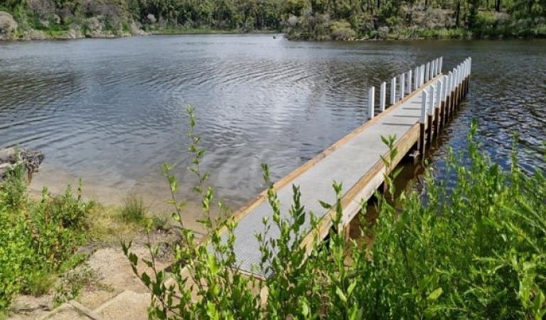
New jetty at Sou West Arm
The project
The Black Summer bushfires in 2019-20 heavily impacted areas throughout Croajingolong National Park. Many campgrounds and park facilities, such as picnic tables, jetties, and toilets, destroyed in the fires have since reopened or been reinstated, while work continues at some sites. Parks Victoria is also upgrading park facilities not impacted by the fires to enhance visitors' experiences.
Project timelines
The following timelines are subject to assessments, permits, and on-ground and construction industry conditions. Timelines will be updated here as projects progress.
- Mallacoota Inlet Jetties and day visitor areas: Approvals are expected in late 2025 and following that, procurement of construction works will start.
- Thurra River Bridge: DEECA anticipates completion of the bridge by late 2025.
- Thurra River Campground: Anticipated to reopen early 2026.
- Point Hicks Visitor Precinct: The delivery of this project is contingent on the completion of the Thurra River Bridge rebuild. The bridge is currently expected to be completed in late 2025.
- Toilets at Genoa River Fire Trail, Sandy Point, and Sou West Arm: Construction will commence when all permits and approvals are received which is expected to be late 2025.
Environmental management
Croajingolong National Park has a wide variety of highly significant coastal landforms including tidal inlets, estuaries and lagoons, extensive sand dunes, and prominent rocky cliffs. It is home to 1,000 recorded native plant species, 43 species of threatened native fauna, including the Little Tern, Ground Parrot, Eastern Bristle-bird, Eastern Broad-nosed Bat, and Australian Fur Seal, and one quarter of Australia’s bird species.
Ecological assessments are being completed to protect flora and fauna during on-ground works.
Putting safety first
Visitor safety is our number one priority when considering risk in parks.
While nature will always be unpredictable, our projects and maintenance works help minimise risks and help people explore the great outdoors safely.
Parks Victoria is responsible for continuously managing and maintaining over 50,000 pieces of infrastructure across the state annually.
We’re also delivering new projects to help visitors get into nature. These are thoroughly planned and prepared to keep people and projects separate – and safe.
When visiting a park where projects are happening, especially during construction, it’s important that people follow the direction of signs, stay out of fenced and restricted areas, and listen to Parks Victoria staff and work crews.
Who we’re working with
While there is no Registered Aboriginal Party (RAP) for the park, there are a number of Traditional Owner groups that have a connection to the area. Parks Victoria is consulting with the Traditional Owner groups to understand the cultural values of these places.
We’re also working with Mallacoota and District Recovery Association (MADRA), East Gippsland Shire Council, Gippsland Port Authority, Department of Energy, Environment and Climate Action (DEECA), and East Gippsland Catchment Management Authority.
Access changes
For information about changes to public access within Croajingolong National Park please visit the park page for the change of conditions section.
During the recovery works there may also be temporary closures to allow construction and ensure public safety. Access changes will be signposted and updated on this website.
Project funding
Victorian Government Gippsland Tourism Recovery Package for improving facilities around Mallacoota Inlet: $2.8 million
Mallacoota and surrounds bushfire recovery insurance: $1.4 million
Thurra River Bridge and Campground insurance: $10 million
Victorian Government Point Hicks Visitor Precinct Funding, for upgrading access to Point Hicks Lightstation and associated facilities: $3.85 million
Other information
- Bushfire recovery information session held 23 November 2023.
- Recording of bushfire recovery information session.
- Bushfire recovery information session Questions and Answers.
- For other bushfire and flood recovery updates visit Buchan Caves Reserve and Cape Conran Coastal Park.