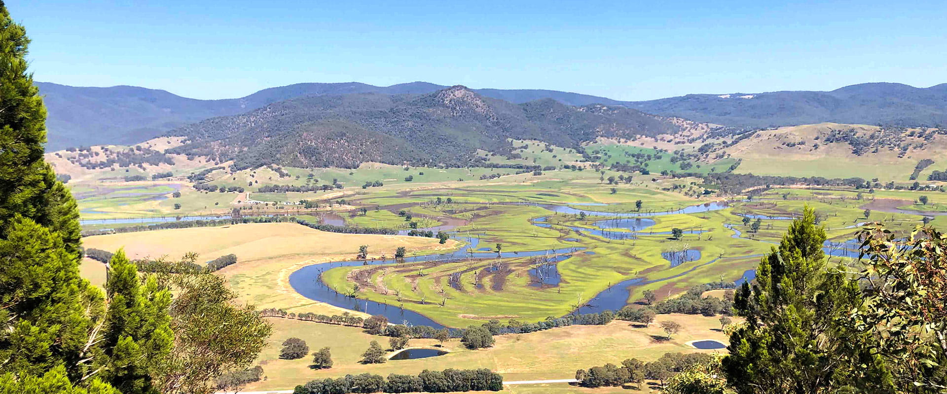
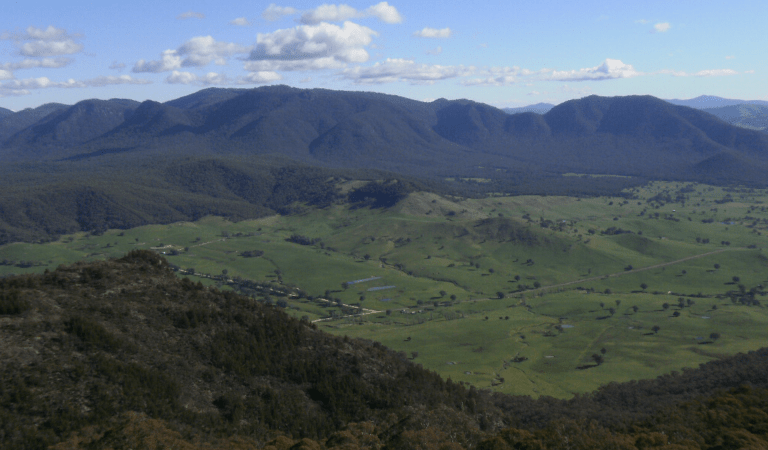
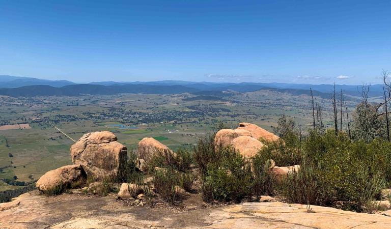
The Murray River tumbles down from its source in the Alps through mountains and floodplains to Lake Hume, passing forests, farmland, parks and reserves. Every bend offers a fresh scene and opportunities for recreation in a beautiful setting of peaceful valleys and rugged hills.
The river is relatively narrow above Tintaldra – clean and clear like a mountain stream with gravel bars – gradually widening as it descends and transforms into the iconic Murray River of the floodplains.
There are many tranquil spots along the river to go for a paddle in your canoe or kayak or enjoy angling or fly fishing for trout, Murray Cod and Redfin. Riverside camping is available at several bends in the River Murray Reserve and Clarke Lagoon Wildlife Reserve. Most sites have no amenities, except Indi Bridge which has a toilet, and Bunroy Creek which has a toilet and picnic tables.
In summer, swimming, fishing, canoeing, bushwalking, biking and four-wheel driving are popular. Birdwatchers and nature lovers will find much to enjoy along the river and up into the surrounding hills.
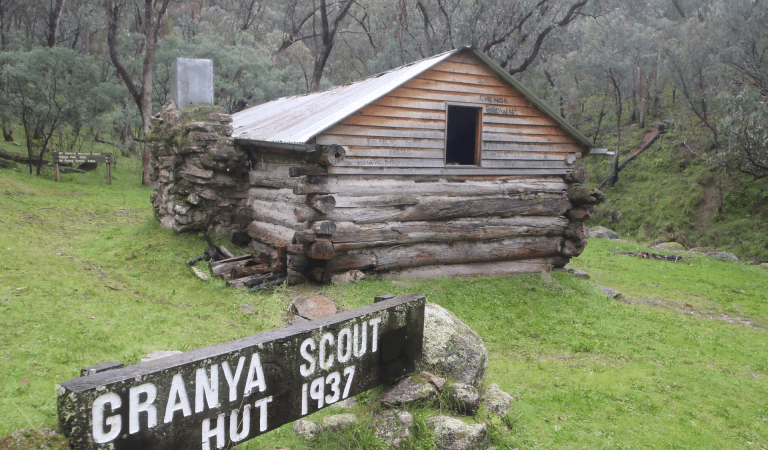
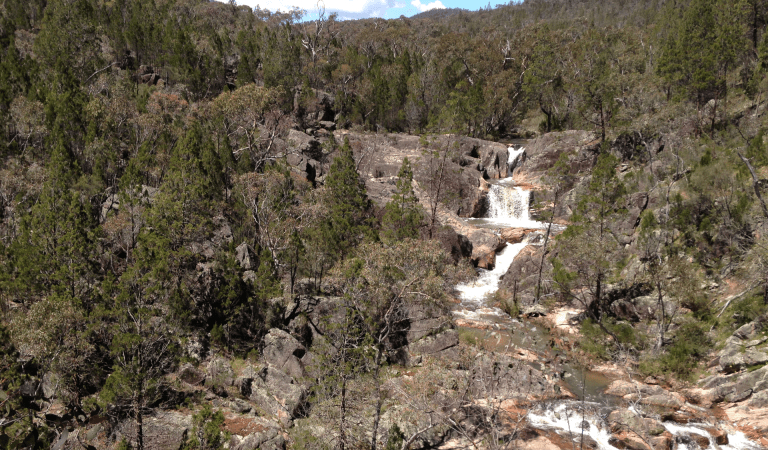
Visitors keen to explore the Murray mountain parks might prefer the Cotton Tree Creek Camping Area in Mount Granya State Park or The Kurrajongs Camping Area in Mount Lawson State Park. Both are close to the river and have toilets, picnic tables, firepits and walking tracks. Nearby Burrowa Pine Mountain National Park supports a diverse range of habitats, rare plant life and the beautiful Cudgewa Bluff Falls.
All riverside campsites are free, no bookings required. For more information about the different sites along this reach of the river, including what regulations apply (for example whether dogs and campfires are allowed), click on the links below the map. Check out additional advice on campfire regulations and safety.
When you’ve decided where to visit, please check the change of condition notices in the need to know section. Visitor sites along the Murray are sometimes closed for your safety due to floods or damaged roads and amenities.
Things to do
Burrowa Pine Mountain National Park
Mount Granya State Park
Mount Lawson State Park
Mount Mitta Mitta Regional Park
How to get there
Upstream of Lake Hume
When you're there
Need to know
Upstream of Lake Hume
Accessibility
Visiting a park can be more of a challenge for people with disabilities, however in Victoria there are a wide range of facilities to help people of all abilities enjoy our wonderful parks around the state.
Assistance dogs are welcome in Parks Victoria parks and reserves. Entry requirements apply for parks and reserves that are usually dog prohibited, such as national parks.
Bushfire safety
The parks and reserves along the Victorian side of the Murray River above Lake Hume are in the North East fire district.
Bushfire safety is a personal responsibility. Anyone entering parks and forests during the bushfire season needs to stay aware of forecast weather conditions. Check the Fire Danger Rating and for days of Total Fire Ban at www.emergency.vic.gov.au, on the VicEmergency smartphone app or call the VicEmergency Hotline on 1800 226 226. There is limited or no mobile reception away from towns along the river, so check the forecast before you set out and tune into local radio stations for updates.
No fires may be lit on Total Fire Ban days. On Catastrophic Fire Danger Rating days many parks close for public safety. Do not enter parks. If you are already in a park, leave the night before or as early as possible in the morning. Check below for park closures or call 13 1963.
Tree safety
Do not park, camp or rest under or near large trees, like River Red Gums. Branches may fall at any time and swing away from the tree. Whole trees can also fall without warning. Rope swings are not recommended.
Water safety
Rivers may have fast currents, cold water, low visibility, underwater objects, slippery rocks, shallow areas, unstable banks, drop offs and deep holes. Always enter the water slowly, feet first. Do not dive or jump in. Submerged objects can cause neck or spinal injuries. Never swim alone or in flood waters. Drinking alcohol significantly increases the risk of drowning. Always actively supervise children in or near water: children under ten should always be within sight; children under five should always be within reach. Lifejackets and flotation devices are recommended.
When the river is in flood, some areas of the River Murray Reserve may be closed for public safety. Check below for the latest conditions and respect closures and signage. Do not walk, ride, or drive through flooded areas.
Mosquitoes
Mosquito-borne diseases, including Ross River Fever and Barmah Forest Virus occur in the area. Avoid being bitten by using repellent and wearing long sleeves and pants, particularly around dawn and dusk.
Change of Conditions
Nature being nature, sometimes conditions can change at short notice. It’s a good idea to check this page ahead of your visit for any updates.
-
Notices Affecting Multiple Sites
Construction Underway- Karadoc and Outlet Creek
Work is underway at various sites to improve access for visitors, park users, and emergency services, helping more people enjoy parks.Construction works will include upgrading ageing infrastructure to improve access and deliver beneficial environmental and conservation outcomes.Construction detailsWorks commence: Monday 1 June 2026Track closed: Monday 1 June 2026 to Friday 31 July 2026 (no vehicle or pedestrian access)Closed areas include Edey RoadAccess during worksAccess to the Karadoc Boat Ramp is not available during this time. Boat ramp access is available downstream via the Redcliffs Boat Ramp or upstream via the Horse Shoe Bend Boat Ramp.Thank you for your patience while these important works are carried out.Attachments: RFMF Signs_Repair_Works_Underway_Karadoc (1) (160KB)
Construction Underway- Bottle Bend (Cottrell Road)
Construction Underway- Bottle BendWork is underway at various sites to improve access for visitors, park users, and emergency services, helping more people enjoy parks.Construction works will include upgrading ageing infrastructure to improve access and deliver beneficial environmental and conservation outcomes.Construction detailsWorks commence: Monday 1 June 2026Track closed: Monday 1 June 2026 to Friday 31 July 2026 (no vehicle or pedestrian access)Closed areas include Cottrell RoadAccess during worksDispersed camp sites at Bonnie Doon Bend and Echo Point remain accessible via the central track.Thank you for your patience while these important works are carried out.Attachments: RFMF Signs_Repair_Works_Underway_Bottle (1) (162KB)
Temporary closure due to inundation - Yarrawonga Regional Park and River Murray Reserve between Yarrawonga and Cobram
Water releases from Yarrawonga Weir are continuing to cause river level rises along the Murray River between Yarrawonga and Barmah – inundating low lying areas adjacent to the river. The following areas remain closed:Yarrawonga CommonChinamans BendForgesBruce’s BendNevins BendBourkes BendCobrawonga IslandScotts BeachCampsites and areas close to the river between Yarrawonga and Cobram continue to be affected. Floodwater is impacting access tracks, making them impassable to all vehicle types.Stay informed - monitor your local conditions and remain alert.- Move
vehicles, caravans, camping equipment and other belongings away from
low-lying areas before access is cut off.
- Parks
Victoria has closed some park access gates due to the rising river levels.
These closures are in place for your safety.
- Do
not drive through floodwater or around road closure signs.
- Avoid
walking through flooded areas.
- Boating
in floodwaters is dangerous due to debris, submerged trees and other
hidden dangers.
Gunbower National Park and Murray River Reserve access changes
Recent rainfall and a high river event has resulted in some natural flooding inflows into Gunbower National Park and the Murray River Reserve on Gunbower Island. Access to some areas may be restricted and 4WD vehicles are recommended due to slippery access roads. Please do not drive through flood water.Some track closures within Gunbower State Forest may be implemented over coming days - please check the DEECA public access map (https://mapshare.vic.gov.au/webmap/publicaccess/) for details. - Move
vehicles, caravans, camping equipment and other belongings away from
low-lying areas before access is cut off.
-
Notices Affecting Multiple Parks
Murray River Adventure Trail
Stage One of the Murray River Adventure Trail proposes new canoe and kayak launches, pedestrian links and new facilities at key visitor sites from Barmah National Park to Koondrook. Stage One will pass through Echuca, Murray River Reserve, Gunbower National Park and Lower Goulburn National Park. Find out more about the project.