Rhyll Local Port Area Plan Project
Project status
December 2024:
- View the Final Local Port Area Plan here
- View the Community Engagement Summary Report here
.jpg?h=200&w=1000&rev=9e9c1006c7d9444fb43e0cb87042f916&hash=B44864548F38FEBEE31A2D9C6803B96B)

Above: Rhyll Jetty - the proposed design solution (Source: FSC Range, 2024)
The project
This project is being delivered on Bunurong Sea Country.
The Rhyll Local Port Area Plan, developed as part of the Victorian Governments Sustainable Local Ports Framework, aims to highlight Rhyll as a port facility with diverse uses. It addresses both current and future demands, ensuring safe, navigable waters and port facilities for all port users.
The plan outlines a strategic framework for managing the port area and guiding future investments. Key elements include:
- Preserving the heritage character and significance of the jetty and local port precinct
- Adding a new pontoon for berthing and pedestrian access across all tidal levels
- Enhancing safety and accessibility on the jetty with new handrails, solar lighting and a new Disability Discrimination Act (DDA) compliant gangway for access to the T-head
- Expanding the landing zone to ease congestion and help with crowd flow, especially during cruise ship tender arrivals and departures
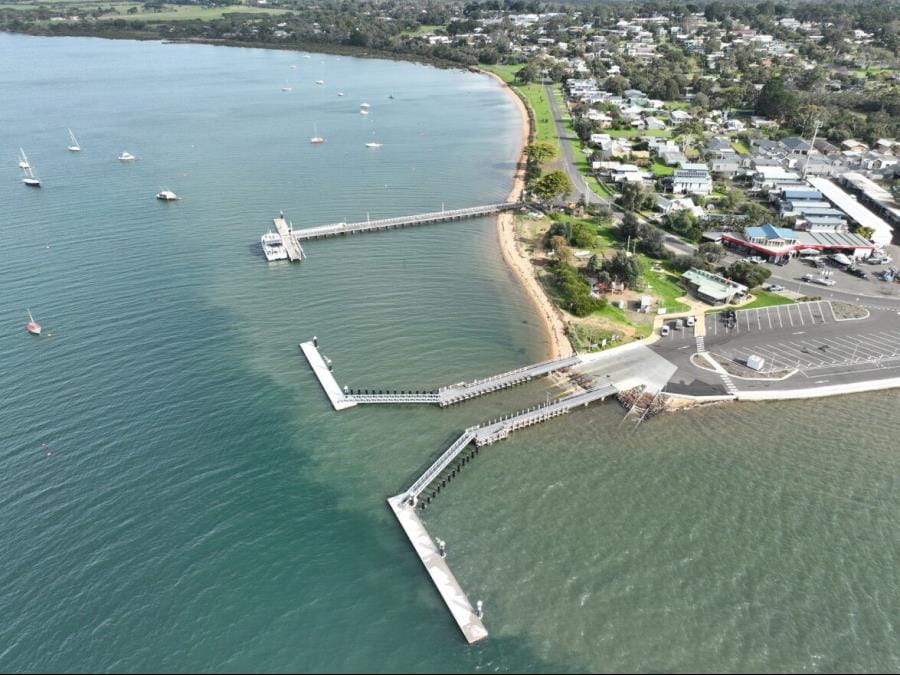
An aerial view of Rhyll local port area and supporting infrastructure (Credit: Better Boating Victoria)
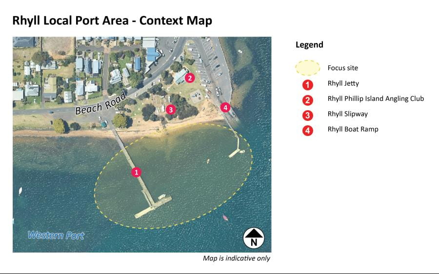
Map of the Rhyll Local Port Area Plan showing boundary of project focus site. Note: aerial map does not reflect recently upgraded boat ramp.
Background
Rhyll Jetty, a valued destination on Phillip Island in Western Port, is managed by Parks Victoria, which oversees Port Phillip and Western Port. Together, these local ports cover 263,000 hectares, including waterways, marine protected areas, channels, piers, jetties, moorings, and navigation aids.
In 2023, Parks Victoria began developing a Local Port Area Plan for the Rhyll Jetty and its surrounding waters to ensure it remains safe and functional as a key maritime asset. Following technical investigations and community and stakeholder feedback, the final plan was published in December 2024.
The project, part of the Victorian Government’s Sustainable Local Ports Framework and Parks Victoria’s local ports forward planning program will guide future investments and offer a sustainable approach to supporting economic, tourism and community needs across local ports.
Project funding
This planning project is funding by the Victorian Government via the Department of Transport and Planning.
Who are we working with?
A project reference group comprising representatives from Parks Victoria, Bass Coast Shire Council, Destination Phillip Island, Department of Transport and Planning, and Bunurong Land Council Aboriginal Corporation are advising on the project.
Project timeline
- Background research and technical investigations – Spring 2023 completed
- Preparation of the draft plan – Late Spring / Summer 2023 completed
- Community consultation of draft plan – July / August 2024 completed
- Feedback considered – Winter 2024 completed
- Final plan released – Summer 2024 completed
Document Library
- Download the Final Rhyll Local Port Area Plan 2024 (word accessible version)
- Download the Final Rhyll Local Port Area Plan 2024 (PDF)
- Download the Community Engagement Summary Report 2024
- Download the draft Rhyll Local Port Area Plan 2024 pdf
- Download the draft Rhyll Local Port Area Plan 2024 word accessible doc.
- Download the Rhyll Jetty Heritage Review 2023
Staying updated
For general enquiries email engage@parks.vic.gov.au or call us on 13 1963.
Subscribe for project updates.
Related information
Parks Victoria is the local port manager for Port Phillip, Western Port and Port Campbell. The three local ports combined include 263,000 hectares of waterway, marine protected areas, channels, piers and jetties, moorings and aids to navigation.
Parks Victoria is currently undertaking a local port area planning process for St Leonards in Port Phillip. Final plans have been released for, Sorrento, Mornington, Williamstown and Sandringham Harbour.
Frequently asked questions
What is a local port area plan ?
The Sustainable Local Ports Framework introduces local port area plans to help prioritise future investment in local port infrastructure where it is needed most. These plans focus on current and future uses/development, ensuring local ports remain equipped to meet changing demands.
Why is the plan needed?
There are many changing circumstances that have the potential to influence the future operation of the local port area, such as accommodating future demands for commercial and visitor berthing, the deteriorating condition of Rhyll Jetty, and sea level rise. The plan will also consider ways to make the jetty and surrounding waters safer and more accessible; and guide Victorian government on the priorities for the repair and renewal of infrastructure to meet future economic, tourism and community needs.
Who prepared the plan?
Parks Victoria, the local port manager, led the development of this plan, with guidance from a Project Reference Group. This group included representatives from Parks Victoria, Bass Coast Shire Council, the Department of Transport and Planning, Destination Phillip Island, and the Department of Energy, Environment and Climate Action.
Whilst the Bunurong Land Council Aboriginal Corporation (BLCAC) couldn’t participate in this plan’s development, Parks Victoria will continue to work with BLCAC on future projects and planning in the area.
Who did you consult with to prepare the plan?
Stage 1- Stakeholder / Key User Consultation
In Spring 2023, Parks Victoria met with key local stakeholders and user groups to discuss the current uses, challenges, and future vision of the Rhyll local port area. Early input from these discussions, along with guidance from the Project Reference Group helped shape the draft plan.
Stage 2 – Community Consultation
The next phase gathered feedback form the broader community to gather and refine the draft plan. From 16 July to 12 August 2024, 29 people shared their ideas and suggestions. The findings from this consultation, and how community feedback shaped the plan, are available here
Who is responsible for managing Rhyll Jetty?
Parks Victoria is responsible for the management of Rhyll Jetty and on-water infrastructure, as both the Port Manager for the local port of Western Port and as the Committee of Management for the Crown Land Reserve. Bass Coast Shire Council manages the foreshore, public boat ramp, and parking as Committee of Management.
When will the plan be implemented?
The plan sets out a future direction for Rhyll and will be used to direct and prioritise future investment. Any changes proposed by the plan will need to be further developed and costed.
How will the heritage values of the precinct be considered in the future plan?
As part of the planning process, Parks Victoria sought appropriately qualified consultants to provide advice on the heritage values of Rhyll Jetty. Refer Document Library - Rhyll Jetty Heritage Review 2023
What is the current condition of Rhyll Jetty?
Rhyll Jetty was built more than 45 years ago and will reach the end of its design life in the coming years. Since mid-2021, the jetty has been closed to service vehicles, and its load limit was lowered to ensure safety and prevent further wear. The measure allows continued community access while funding is secured to restore vehicle access.