Grade 4

Grampians National Park is part of the Gariwerd Aboriginal cultural landscape. Parks Victoria respects the deep and continuing connection that Traditional Owners have to these lands and waters, and we recognise their ongoing role in caring for Country.
![]()
![]()
![]()
Experience the serenity of nature on this secluded walk exploring previously untracked terrain on the southern reaches of the Mt William Range.
Itinerary highlights
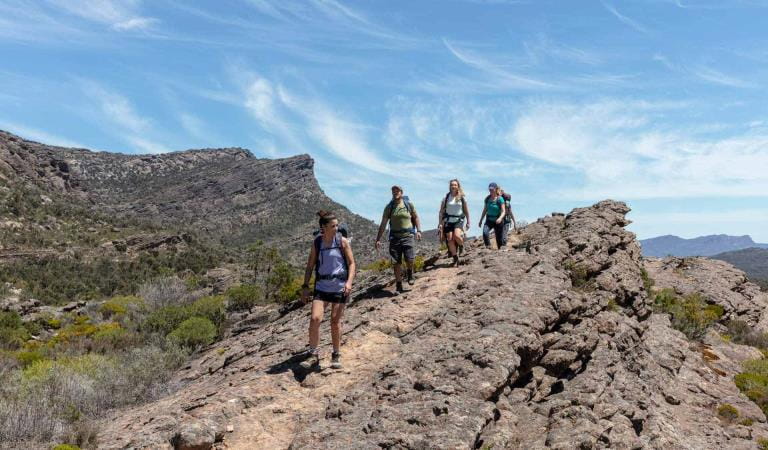
This itinerary provides amazing views over the Serra Range, hikes through rocky knolls, waterways, wetlands and open grassland camping. C5-S2 sections on GPT topographic map.
Climb and descend a succession of six knolls and saddles passing through ancient old growth forests and lower swampland plains with stands of native Oyster Bay Pines along the way. Take in views of farmland to the east and south-east reveal a myriad wetlands.
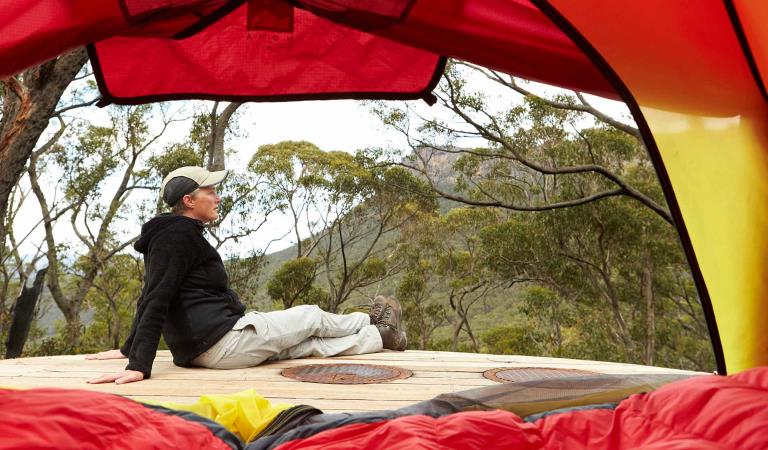
Continue hiking the ups and downs of the most southern ridgeline of the Mt William Range and settle in at Wannon Hike-in Campground for the night in a reclaimed farmland gully. Explore surrounding ridges for stunning sunset views.
Water safety
For your safety, having enough water along the Grampians Peaks Trail for hydration and cooking is so important. Our water information and availability page includes the locations (with latitude and longitude references) of serviced water tanks. All water tanks along the trail are untreated. So you need a safe way to treat water for drinking.
When planning this incredible hike, read the important Grampians Peaks Trail Plan and Prepare Guide.
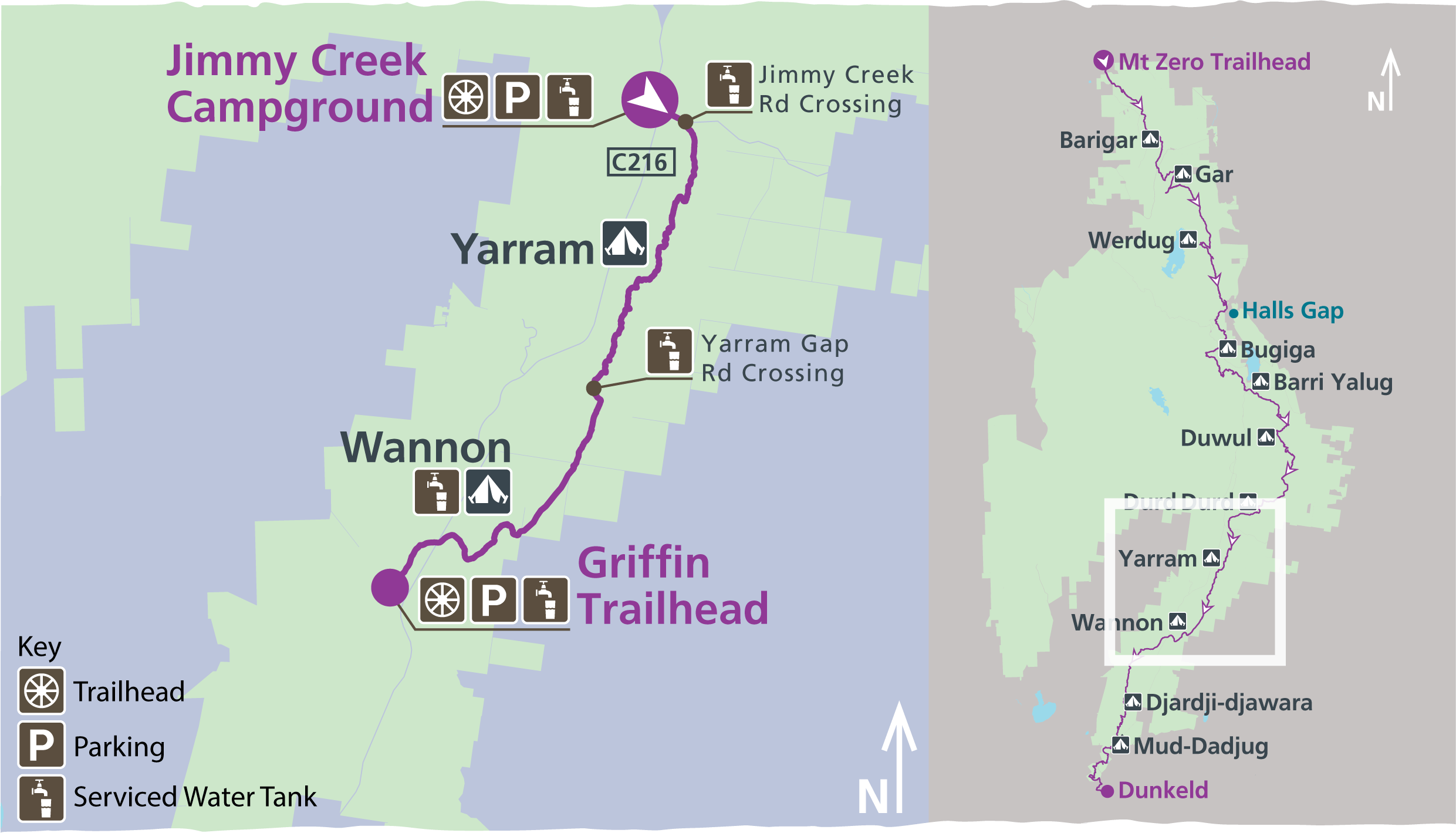
Day one: (C5) Jimmy Creek Campground to Yarram Hike-in Campground (7.3km)
From the campground cross the road and climb up onto the Mt William Range and follow the range to its most southern extent. Enjoy views along the eastern slopes of farmland, small waterways and wetlands. The track passes through a gully and high cliffs to camp in a high saddle at Yarram Hike-in Campground.
Day two: (S1) Yarram Hike-in Campground to Wannon Hike-in Campground (11.1km)
This day will take hikers down steeply to a gully and then onto the western edge of the range, with views of the jagged Serra Range. Continuing south uphill and then descend to cross Yarram Gap Road. From the trailhead traverse a succession of rocky knolls with views east, west and south across to Mt Abrupt to find your camp in an open, grass clearing at Wannon Hike-in Campground.
Day three: (S2) Wannon Hike-in Campground to Griffin Fireline / Traihead (5.6km)
The final day of this itinerary takes hikers through a heavily forested saddle and slowly descends into open woodland and then grassland, to meet the Wannon River. Cross the river and follow the boardwalk that winds through wildflower-rich open woodland to the Grampians Tourist Road and then onto Griffin Fireline Trailhead.
Bookings and itinerary information
This 3-day hike connects with Yarram and Wannon 3-day hike to the north and continues south to the Djardi-djawara and Mud-dadjug 3-day hike. The trailhead for this itinerary is Jimmy Creek. Find out more about the central Grampians walks in the official map for Grampians Peaks Trail. All itineraries require a car shuffle from start to finish. If you only have one vehicle, please visit Brambuk the National Park and Cultural Centre for other pick-up or walk options.
Camping fees
This itinerary includes two nights at two different, dedicated campgrounds: first night at Yarram Hike-in Campground and second night at Wannon Hike-in Campground. These are booked as an all-inclusive itinerary - all you need to do is choose the date of your first night to book. We recommend booking your 3-day hike well in advance of your planned departure to ensure there is tent pad availability at each campground.
Once usual pricing commences, the 3-day itinerary cost is $100.80 for up to two people on a 3.5m x 3.5m standard tent pad.
These hike-in campgrounds are in very remote locations, you're not near a busy road or carpark, so you feel the reward of being deep inside the national park. They have been built with a good level of amenity that is well designed, sympathetic to the landscape and sustainable. As such, they are priced higher for the value they provide. The price for a standard tent pad for a 3-day/2-night hike is roughly $50 per night ($25 p/person if sharing) in camping fees for these unique, well-equipped hike-in campgrounds. These fees contribute towards the operation and maintenance of this unique hiking experience and helps to protect the environmental values of this heritage-listed national park.
Campground information
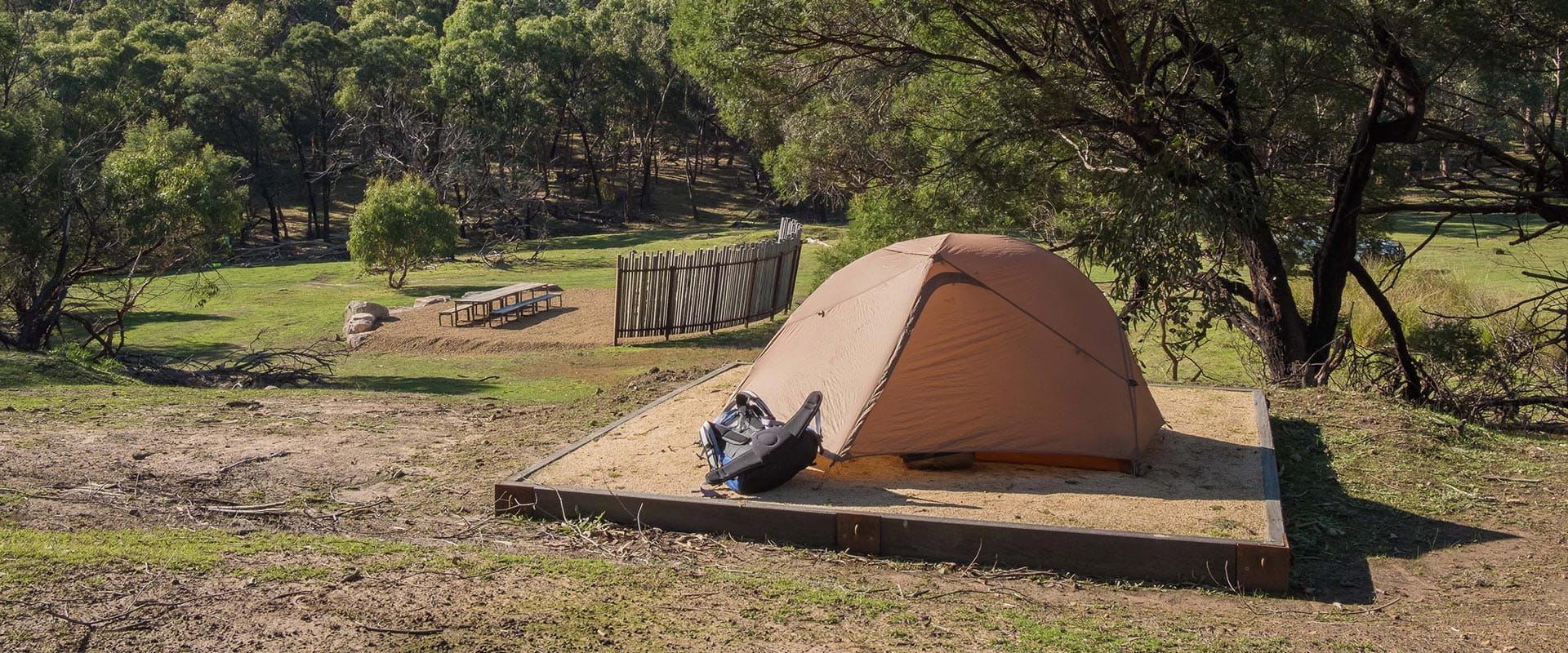
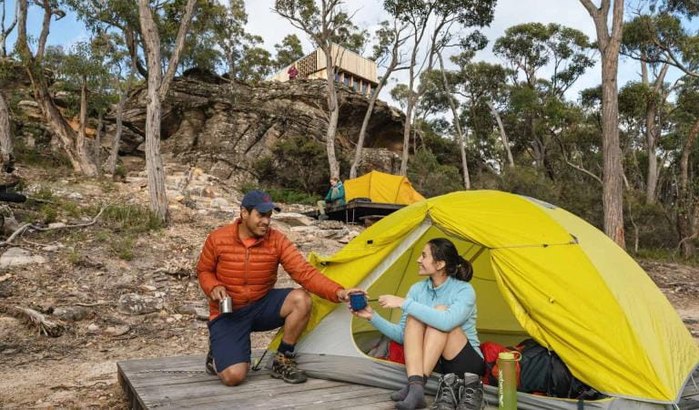
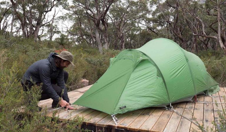
Campgrounds have a mix of 3.5m x 3.5m timber tent platforms and granite sand pads with steel chains that can be used to secure your tent. Additional guy rope may be needed for tent vestibules or tunnel style tents. Each campground has been individually designed the fit within the surrounding landscape. They feature an unpowered communal area for meal preparation, basic toilet facilities and water collection points
Patchy/poor mobile service between Yarram Hike-in Campground and Yarram Gap Road. Good service on the top of the range between Yarram Gap Road and Wannon Hike-in Campground. No service at Wannon Hike-in Campground. The use of fuel stoves in all hiker camps is permitted but open campfires are not allowed. Please take your rubbish with you on the entire journey and dispose of it when you get home.
How to get there
Yarram-Wannon Multi-day Hike
Jimmy Creek Campground is located halfway between Halls Gap and Dunkeld, along Grampians Road. From the campground cross the road to begin this 3-day hike.
From Horsham/Wimmera River Bridge (100kms, 1hour and 15mins): Drive south-east on the Western Highway (A8) for 44.7kms. Turn right and follow Mt Drummond Rd, Greenhole Rd and Fyans Creek Rd for 20.7km to Grampians Road (C216). Turn right and follow Grampians Tourist Road (C216) for 32.8km to reach Jimmy Creek Campground.
From Halls Gap (27.3km, 20minutes): Drive south-east on Grampians Tourist Road (C216) for 27.3kms.
From Melbourne (252km, 3 hours and 5mins): Drive west on the Western Highway (A8) to Ararat. At Ararat, turn onto the Pyrenees Highway and follow signs towards the Grampians National Park.
When you're there
Make Brambuk - The National Park and Cultural Centre in Halls Gap your first stop. Here you can explore what Gariwerd means to Aboriginal people and find information about visiting Grampians National Park.
Safety is your responsibility
- At lookouts, never climb over barriers. Your safety is more important than a social media post.
- There are steep cliffs in the park. Keep to the track, mind your footing and supervise children.
- Many walking tracks involve rock steps, uneven and slippery track surfaces, water crossings and rock hopping.
- Mobile phone service is unavailable in many areas of the park. Seek higher elevations for service.
- Plan your timing, return from walking well before dusk.
Emergency markers
In the event of an emergency, call Triple Zero 000 or 112 to access police and emergency services. Be aware that you may travel out of mobile phone range. Many of our parks feature emergency markers, which are special green signs with a unique code on them so emergency responders can pinpoint your exact location.
Need to know
Yarram-Wannon Multi-day Hike
Walking track grades
Hikes along the Grampians Peaks Trail have been graded using the Australian walking track grading system, which is a primary means of informing people about the features of walking tracks, so they can gauge their suitability for a particular track. Under the system, walking trails are graded on a difficulty scale from grades one to five.
Grade 1: No bushwalking experience required. Flat even surface with no steps or steep sections. Suitable for assisted wheelchair users.
Grade 2: No bushwalking experience required. A hardened or compacted surface which may have gentle hill sections or occasional steps.
Grade 3: Suitable for most ages and fitness levels. Tracks may have short steep sections, a rough surface and many steps.
Grade 4: Bushwalking experience recommended. Tracks may be long, rough and very steep. Directional signage may be limited.
Grade 5: Very experienced bushwalkers with specialised skills, including navigation and emergency first aid. Tracks likely to be very rough, very steep and unmarked.
Hiking tips for Grampians Peaks Trail
- An Official Grampians Peaks Trail topographic map (for North/Central/South) available from Brambuk the National Park and Cultural Centre, Halls Gap and other visitor outlets in nearby towns (and compass)
- Waterproof jacket and pants, thermal layers, breathable-fabric layers, beanie, sun hat and sunscreen.
- Hiking boots or shoes with a good tread and support.
- Water and food for all meals and snacks, plus extra for an emergency. Fuel stove for cooking.
- Drinking water treatment equipment for untreated water tanks at campground.
- 3-season tent, 3-season sleeping bag, mat and cord/thin rope to attach your tent to timber tent platforms.
- Lightweight gas or liquid fuel stove, matches/lighter, cooking pot and utensils.
- Head torch with spare batteries. Useful when moving around a campground at night.
- Good quality first aid kit with snake bite bandage.
- Mobile phone with USB cable – you can recharge at campgrounds along the trail. We also recommend taking a Personal Locator Beacon (PLB) for extra safety and a small radio to listen to weather or bushfire updates.
- Toilet paper, trowel and a bag to carry your rubbish.
- Waterproof pack liner to keep everything in your hiking backpack dry.
Be bushfire aware
The warmer months are the perfect time to experience regional Victoria. However, Victoria is one of the most fire-prone areas in the world. During summer in Victoria, the weather can be very hot and dry and the risk of summer lightning storms can increase the chance of bushfires.
Follow these bushfire safety tips to ensure that your experience is safe and enjoyable.
Change of Conditions
Nature being nature, sometimes conditions can change at short notice. It’s a good idea to check this page ahead of your visit for any updates.
-
The Fortress Walk (Victoria Range Remote and Natural Area, Grampians (Gariwerd) National Park)
The Fortress Walk and Hike-in Campground – Temporary closure
The Fortress Walk and The Fortress Hike-in Camp remain closed to visitors due to track damage from the 2024/25 summer bushfires.For more information on alternate walks in the western section of the Grampians (Gariwerd) National Park visit Brambuk the National Park and Cultural Centre in Halls Gap or call 03 8427 2058. -
The Chimney Pots Walk (Victoria Range Remote and Natural Area, Grampians (Gariwerd) National Park)
The Chimney Pots Walk – Temporary closure
The Chimney Pots Walk remains closed to visitors due to track damage from the 2024/25 summer bushfires.For more information on alternate walks in the western section of the Grampians (Gariwerd) National Park visit Brambuk the National Park and Cultural Centre in Halls Gap or call 03 8427 2058. -
Red Gum Walk (Grampians (Gariwerd) National Park)
Red Gum Walk – Temporary closure
The Red Gum Walk remains closed to visitors due to track damage from the 2024/25 summer bushfires.For more information on alternate walks in the western section of the Grampians (Gariwerd) National Park visit Brambuk the National Park and Cultural Centre in Halls Gap or call 03 8427 2058. -
Strachans Campground (Grampians (Gariwerd) National Park)
Strachans Campground –Temporary Closure – 13 April – 30 July 2026
Strachans Campground will be closed to visitors between 13 April and 30 July 2026 while major upgrade works are completed.For further information contact Brambuk the National Park and Cultural Centre in Halls Gap (Ph 8427 2058). -
Mackenzie Falls Day Visitor Area (Grampians (Gariwerd) National Park)
Mackenzie Falls (Migunang wirab) - Upcoming closure for major construction works – 9 February 2026 to the end of 2026
This update is to provide information for the planned construction work at Mackenzie Falls in the Grampians (Gariwerd) National Park, and closures while the works happen.The works at Mackenzie Falls precinct includes the construction of a new viewing platform at the base of the falls, upgrades to the carpark and the Bluff Lookout Walk and other important safety improvements to stabilise rock and improve walking tracks.
The Mackenzie Falls carpark and all walking tracks in the precinct including Broken Falls Walk, Mackenzie Falls Walk to the base (from the carpark), the Bluff Lookout Walk, and parts of Mackenzie Falls River Walk will close when construction starts on Monday, 9 February, 2026, and we anticipate that construction work will finish by the end of 2026.The carpark will be a construction site throughout the works period with large machinery operating and materials being stored on site. There will be no access for all vehicles or visitors at Mackenzie Falls Precinct during construction.Zumsteins Picnic AreaWhen construction works start at Mackenzie Falls precinct, parking at the popular Zumstein picnic area will be limited, especially for large vehicles (buses and caravans) during weekends and holiday periods.Zumsteins to Fish Falls – This popular walk to the beautiful Fish Falls is a 1.5 to 2 hour return walk (Grade 3) – walkers should have a reasonable fitness level, carry water and wear sturdy walking shoes as the track can be rocky with uneven surfaces and some steep sections.Mackenzie River WalkFrom May 2026 until works are complete, the base of Mackenzie Falls will not be accessible via the Mackenzie River Walk from Zumsteins Picnic Area.
For further information on the Mackenzie Falls (Migunang wirab) project visit https://www.parks.vic.gov.au/projects/western-victoria/mackenzie-falls-revitalisation
Popular day visitor sites such as Reeds Lookout, the Balconies, Boroka Lookout, Silverband Falls and various walks with large bus carparking will still be available. For further information on the Mackenzie Falls River Walk contact Brambuk the National Park and Cultural Centre in Halls Gap (Ph 8427 2058).Please keep up to date with closures through the Change of Conditions page for Grampians (Gariwerd) National Park. -
Grampians (Gariwerd) National Park
Temporary closure of a Glenelg River Road section – 25 May to 17 July 2026
The section of Glenelg River Road from the Stony Creek Road intersection to the Boreang Campground turn off will be closed from Monday 25 May 2026 to Friday 17 July 2026 for roadworks.The southern end of the closure can be accessed via Rose Creek Road. Paddy Castle Walk and Boreang Campground remain open, as does Glenelg River Road, south of Lodge Road.Mount Victory Road will have an increased amount of heavy trucks and machinery. Drivers are urged to slow down and drive with care, particularly in tight corners.For further information please contact Brambuk the National Park and Cultural Centre Phone 8427 2058.Grampians (Gariwerd) National Park - Roads Update 10.07.2026
The Grampians (Gariwerd) National Park has roads temporarily closed due to bushfire and weather impacts.Please observe road closures, traffic hazard signage and always drive to conditions.Seasonal Road Closures are now in place from the 9 June 2026 to 29 October 2026.Please refer to the attached up-to-date road report below.Attachments: Grampians (Gariwerd) National Park - Road Report 10.07.2026 (230KB)
-
Brambuk the National Park and Cultural Centre (Brambuk - The National Park and Cultural Centre Park, Grampians (Gariwerd) National Park)
Brambuk the National Park and Cultural Centre – Building Upgrades in 2026
The Cultural Centre is closed for refurbishment.Parks Victoria is working with a strategic partnership committee of Gariwerd Traditional Owners from Barengi Gadjin Land Council, Eastern Maar Aboriginal Corporation, and Gunditj Mirring Traditional Owners Aboriginal Corporation to ‘reimagine’ the future of Brambuk the National Park and Cultural Centre.Building upgrades are essential to ensure the centre meets current services requirements, accessibility, and compliance to current building regulation. New visitor experiences and activation opportunities including Aboriginal arts, community events and cultural exhibitions are being explored as Brambuk moves towards operation by a Gariwerd Traditional Owner entity.The National Park Information Centre and gift shop remain open.For up-to-date national park information, brochures, maps, permits and access advice contact information staff at Brambuk the National Park and Cultural Centre info@parks.vic.gov.au or phone 8427 2058For Junior Ranger School holiday programs visit https://www.parks.vic.gov.au/things-to-do/junior-rangersFor a list of Grampians (Gariwerd) National Park Licensed Tour Operators Visit https://www.parks.vic.gov.au/ltoFurther details on the Brambuk Reimagining project can be found on the Parks Victoria website https://www.parks.vic.gov.au/projects/western-victoria/brambuk-cultural-centre-upgrade
Add more Grampians Peaks Trail hikes to your itinerary
Djardji-djawara and Mud-dadjug 3-day Hike
Duwul and Durd Durd 3-day Hike
Gar and Werdug 3-day Hike