Grade 4
Grampians National Park is part of the Gariwerd Aboriginal cultural landscape. Parks Victoria respects the deep and continuing connection that Traditional Owners have to these lands and waters, and we recognise their ongoing role in caring for Country.


Hike across the Southern Grampians skyline, with scenic ridgeline and steep mountain terrain along the way to Dunkeld. See sections S2-S4 on GPT topographic map.
Itinerary highlights
These new sections of trail pass through stunted eucalypt forest, the rocky mountain summits of Signal Peak and Mt Abrupt (Mud-Dadjug) hiking through old growth forested saddles and outstanding views west to the Victoria Range, climbing steeply to the summits of Signal Peak and Mt Abrupt (Mud-dadjug) and crossing Bainggug (The Piccaninny) and Mt Sturgeon (Wurgarri) before crossing the Wannon River and walking into Dunkeld.
Water safety
For your safety, having enough water along the Grampians Peaks Trail for hydration and cooking is so important. Our water information and availability page includes the locations (with latitude and longitude references) of serviced water tanks. All water tanks along the trail are untreated. So you need a safe way to treat water for drinking.
When planning this incredible hike, read the important Grampians Peaks Trail Plan and Prepare Guide.
Day one: (S2) Griffin Trailhead to Djardi-djawara Hike-in Campground (10.7km)
Starts at the Griffin Trailhead and climbs through stunted vegetation onto the Serra Range, with outstanding views west to the Victoria Range. Finish the day camping at Djardi-djawara Hike-in Campground below rocky outcrops.
Day two: (S3) Djardi-djawara Hike-in Campground to Mud-Dadjug Hike-in Campground (8.1km)
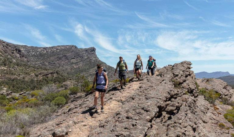
This day's hike alternates between rock steps and jumbles of boulders passing small cliffs and ledges that provide excellent vantage points. Hikers climb steeply to the summits of Signal Peak through a series of small heathy and forested saddles to Mt Abrupt, finishing with your camp at Mud-Dadjug high above the landscape.
Day three: (S4) Mud-Dadjug Hike-in Campground to Dunkeld (14.8km)
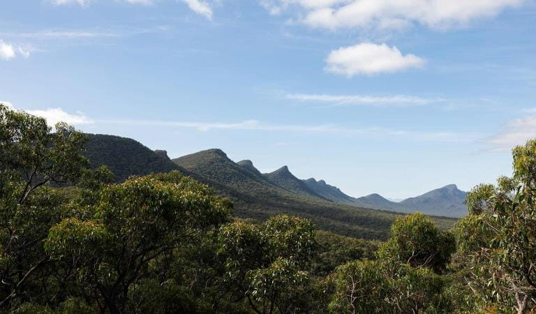
This day crosses Bainggug (The Piccaninny) and Mt Sturgeon, before meandering through red gums, crossing the Wannon River and strolling into Dunkeld. Descend down one last rocky slope towards the farmland below, taking in stunning views out over volcanic plains and the impressive peaks of the southern Grampians from Mt Sturgeon (Wurgarri). To the north are the sedimentary sandstones of Gariwerd; to the south, basalt lava flows from volcanic plains.
Complete your journey through open old-growth Red Gum woodland to arrive at Dunkeld for a hot shower, great meal and comfortable bed.
Bookings and campground information
This 3-day hiking itinerary is the final section of the Grampians Peaks Trail, however you can book itineraries before it, as well as other connecting tracks to allow you to step on and off from various points throughout Gariwerd. The Griffin Trailhead is the starting point for this itinerary. You can find its location in the official maps for Grampians Peaks Trail. All itineraries require a car shuffle from start to finish. If you only have one vehicle, please visit Brambuk the National Park and Cultural Centre for other pick-up or walk options.
Camping fees
The trail itself is free to hikers but camping fees apply to stay overnight. This itinerary includes two nights at two different, dedicated hike-in campgrounds. You will stay your first night at Djardi-djawara Hike-in Campground and second night at Mud-dadjug Hike-in Campground. These are booked as an all-inclusive itinerary - all you need to do is choose the date of your first night to book. If you are planning on staying longer to do more sections of the walk, you can add other itineraries to your booking. We recommend booking your two nights of camping prior to embarking on the walk to ensure there is tent pad availability at each campground.
The 3-day itinerary cost is $100.80 for up to two people on a standard tent pad.
These hike-in campgrounds are in very remote locations, you're not near a busy road or carpark, so you feel the reward of being deep inside the national park. They have been built with a good level of amenity that is well designed, sympathetic to the landscape and sustainable. As such, they are priced higher for the value they provide. The price for a standard tent pad for a 3-day/2-night hike is roughly $50 per night ($25 p/person if sharing) in camping fees for these unique, well-equipped hike-in campgrounds. These fees contribute towards the operation and maintenance of this unique hiking experience and helps to protect the enviornmental values of this heritage-listed national park.
Campground information
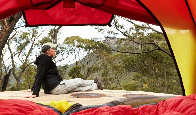
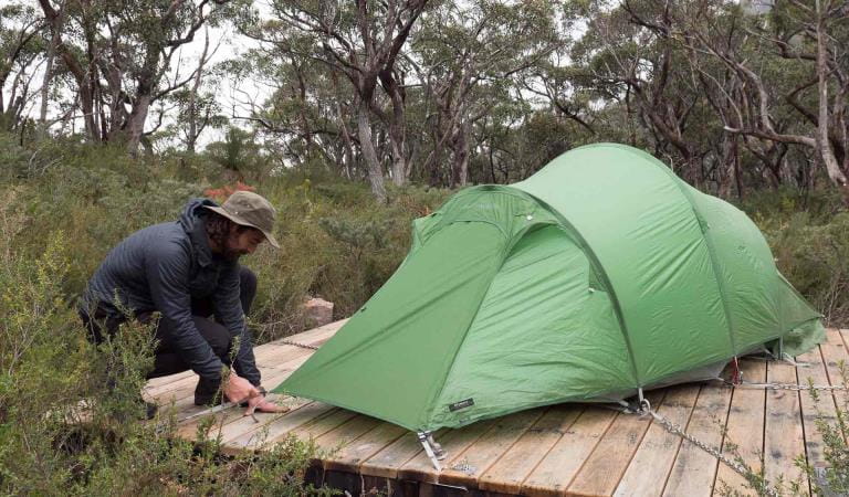
Campgrounds either have timber tent platforms or granite sand pads. Tent platforms have steel chains that can be used to secure your tent. Additional guy rope may be needed for tent vestibules or tunnel style tents. Standard timber platforms and granite sand pads are 3.5m x 3.5m. Each campground has been individually designed the fit within the surrounding landscape. They feature an unpowered communal area for meal preparation, basic toilet facilities and water collection points. The use of fuel stoves in all hiker camps is permitted but open campfires are not allowed and please take your rubbish with you.
How to get there
Djardji-djawara and Mud-dadjug 3-day Hike
From Melbourne (250km, 3hrs 30mins): Drive west on the Western Highway (M8) to Ballarat. From Ballarat take the Glenelg Highway (B160) west to Dunkeld. Turn north onto Victoria Valley Road (C216). Drive 2.6km and turn right on Grampians Tourist Road (C216) to Halls Gap. Drive 16.2km then turn right into Griffin Picnic Area.
From Dunkeld (19km, 15mins): Leave Dunkeld village to the east on the Glenelg Highway (B160). Drive 200m and turn north onto Victoria Valley Road (C216). Drive 2.6km and turn right on Grampians Tourist Road (C216) to Halls Gap. Drive 16.2km then turn right into Griffin Picnic Area.
From Halls Gap (45.7km, 30mins): Drive south on Grampians Tourist Road (C216) towards Dunkeld. After 45.7km turn left into Griffin Picnic Area.
When you're there
Make Brambuk - The National Park and Cultural Centre in Halls Gap your first stop. Here you can explore what Gariwerd means to Aboriginal people and find information about visiting Grampians National Park.
Safety is your responsibility
- At lookouts, never climb over barriers. Your safety is more important than a social media post.
- There are steep cliffs in the park. Keep to the track, mind your footing and supervise children.
- Many walking tracks involve rock steps, uneven and slippery track surfaces, water crossings and rock hopping.
- Mobile phone service is unavailable in many areas of the park. Seek higher elevations for service.
- Plan your timing, return from walking well before dusk.
Emergency markers
In the event of an emergency, call Triple Zero 000 or 112 to access police and emergency services. Be aware that you may travel out of mobile phone range. Many of our parks feature emergency markers, which are special green signs with a unique code on them so emergency responders can pinpoint your exact location.
Need to know
Djardji-djawara and Mud-dadjug 3-day Hike
Walking track grades
Hikes along the Grampians Peaks Trail have been graded using the Australian walking track grading system, which is a primary means of informing people about the features of walking tracks, so they can gauge their suitability for a particular track. Under the system, walking trails are graded on a difficulty scale from grades one to five.
Grade 1: No bushwalking experience required. Flat even surface with no steps or steep sections. Suitable for assisted wheelchair users.
Grade 2: No bushwalking experience required. A hardened or compacted surface which may have gentle hill sections or occasional steps.
Grade 3: Suitable for most ages and fitness levels. Tracks may have short steep sections, a rough surface and many steps.
Grade 4: Bushwalking experience recommended. Tracks may be long, rough and very steep. Directional signage may be limited.
Grade 5: Very experienced bushwalkers with specialised skills, including navigation and emergency first aid. Tracks likely to be very rough, very steep and unmarked.
Hiking tips for Grampians Peaks Trail
- An Official Grampians Peaks Trail topographic map (for North/Central/South) available from Brambuk the National Park and Cultural Centre, Halls Gap and other visitor outlets in nearby towns (and compass)
- Waterproof jacket and pants, thermal layers, breathable-fabric layers, beanie, sun hat and sunscreen.
- Hiking boots or shoes with a good tread and support.
- Water and food for all meals and snacks, plus extra for an emergency. Fuel stove for cooking.
- Drinking water treatment equipment for untreated water tanks at campground.
- 3-season tent, 3-season sleeping bag, mat and cord/thin rope to attach your tent to timber tent platforms.
- Lightweight gas or liquid fuel stove, matches/lighter, cooking pot and utensils.
- Head torch with spare batteries. Useful when moving around a campground at night.
- Good quality first aid kit with snake bite bandage.
- Mobile phone with USB cable – you can recharge at campgrounds along the trail. We also recommend taking a Personal Locator Beacon (PLB) for extra safety and a small radio to listen to weather or bushfire updates.
- Toilet paper, trowel and a bag to carry your rubbish.
- Waterproof pack liner to keep everything in your hiking backpack dry.
Be bushfire aware
The warmer months are the perfect time to experience regional Victoria. However, Victoria is one of the most fire-prone areas in the world. During summer in Victoria, the weather can be very hot and dry and the risk of summer lightning storms can increase the chance of bushfires.
Follow these bushfire safety tips to ensure that your experience is safe and enjoyable.
Change of Conditions
Nature being nature, sometimes conditions can change at short notice. It’s a good idea to check this page ahead of your visit for any updates.
-
Notices Affecting Multiple Sites
Grampians Peaks Trail – Hike-in Campground Closures (sections C3-C5 & S1-S2)
The central and southern sections of the Grampians Peaks Trail (C3-C5 and S1-S2) re-opened for day walking only on the 10th of November 2025.These sections were heavily impacted by the 2024/25 Summer bushfires and incorporate the trail from Borough Huts Campground to Griffin Trailhead (including section S1 –S2 Yarram Gap Road to Griffin Fireline).Barri Yalug, Duwul, Durd Durd, Yarram and Wannon Hike-in Campgrounds and facilities remain closed, as works take place to repair damaged toilets, water tanks, elevated walkways, tent platforms, shelters, and signage.Please note:- Drinking water is available
at serviced water tanks only, located at Grampians Peaks Trail Road
crossings. Important: drinking water is not available at the
Hike-in Campgrounds. Hikers must adjust accordingly and carry sufficient
drinking water.
- Toilet facilities are
available at Borough Huts, Jimmy Creek, Kalymna and Wannon Crossing
campgrounds.
- Mt William Road is closed
until further notice, and vehicle access to the Mount William carpark is
unavailable.
- Please see the Plan and
Prepare Guide for more information on how to plan and prepare, before
accessing the Grampians Peaks Trail.
Please remember, this fire affected landscape is fragile. Stay on formed tracks and be mindful that walking track and surrounding forest conditions have changed.Visit our fire recovery project web page for relevant upgrade information.Check what's open and closed in Grampians (Gariwerd) National Park on the change of conditions web page. If you are visiting the area and require more detailed local information, visit Brambuk the National Park and Cultural Centre at 277 Grampians Rd Halls Gap, open 9am to 4pm, 7 days a week. Alternatively, you can call (03) 8427 2258 or email brambuk@parks.vic.gov.au - Drinking water is available
at serviced water tanks only, located at Grampians Peaks Trail Road
crossings. Important: drinking water is not available at the
Hike-in Campgrounds. Hikers must adjust accordingly and carry sufficient
drinking water.
-
Sundial Peak Walk (Grampians (Gariwerd) National Park)
Sundial Peak Walk and The Bleachers (Sundial Peak) – Temporary closure
Sundial Peak Walk and The Bleachers (Sundial Peak) – Temporary closureSundial Peak Walk and The Bleachers (Designated Climbing Area – Bouldering (Site 83) both remain closed due to track damage from the 2024/25 summer bushfires.Alternative walks from Sundial carpark including The Pinnacle Walk and the Lakeview Lookout Walk.For more information visit Brambuk the National Park and Cultural Centre in Halls Gap or call 03 8427 2058 -
Grampians (Gariwerd) National Park
Grampians (Gariwerd) National Park – What’s Open What’s Closed Update 04.02.2026
Grampians (Gariwerd) National Park – What’s Open What’s Closed Update 04.02.2026During the summer of 2024/2025 the southern and western areas of Grampians (Gariwerd) National Park and the central section of Grampians Peaks Trail were impacted by multiple bushfires. Since then, a staged re-opening has commenced and many popular visitor areas have re-opened in the Northern, Wonderland and Southern areas of the park. However, some visitor sites and roads remain closed in the Sundial, Mount William, Victoria Range, Victoria Valley and Wallaby Rocks areas.Roads in fire impacted areasFor up-to-date information please refer to the Road Report on the change of conditions listings.For more detail on “What’s Open What’s Closed”Please refer to the attached “What’s Open What’s Closed” February 4, 2026, Park Update. It provides a park wide compilation of the staged fire recovery reopenings in 2025/2026.For further information, visit Brambuk the National Park and Cultural Centre in Halls Gap, call Parks Victoria on 131963 or go to parks.vic.gov.auAttachments: GGNP_Park Update_Whats Open-Closed_Feb 4 2026 (1,023KB)
Grampians (Gariwerd) National Park - Roads Update 06.02.2026
The Grampians (Gariwerd) National Park has some roads temporarily closed due to bushfire and flood impacts.Please be aware the movement of visitors in some areas of the National Park is restricted.Please refer to the attached up-to-date road report below.Attachments: Grampians (Gariwerd) National Park - Road Report - 06.02.2026 (218KB)
-
Brambuk the National Park and Cultural Centre (Grampians (Gariwerd) National Park, Brambuk - The National Park and Cultural Centre Park)
Brambuk the National Park and Cultural Centre – Closures throughout 2026
· Cultural tours, activities and venue hire currently unavailable.· Park information centre and gift shop remain open.Parks Victoria is working with a strategic partnership committee of Gariwerd Traditional Owners from Barengi Gadjin Land Council, Eastern Maar Aboriginal Corporation, and Gunditj Mirring Traditional Owners Aboriginal Corporation to ‘reimagine’ the future of Brambuk the National Park and Cultural Centre.The reimagining project aims to renew Traditional Owner management arrangements of the Brambuk precinct and includes careful consideration of the tourism and visitor experiences, commercial opportunities, cultural education and training programs that may be available in the future. As part of this project, there are also building upgrades and refurbishments that require the Cultural Centre to be closed during 2026. However, the park information centre, gift shop and self-guided walks remain available.For Junior Ranger School holiday programs visit https://www.parks.vic.gov.au/things-to-do/junior-rangersFor a list of Grampians (Gariwerd) National Park Licensed Tour Operators Visit https://www.parks.vic.gov.au/ltoFor up-to-date national park information, brochures, maps, permits and access advice contact information staff at Brambuk the National Park and Cultural Centre info@parks.vic.gov.au or phone 8427 2058Further details on the Brambuk Reimagining project can be found on the Parks Victoria website https://www.parks.vic.gov.au/projects/western-victoria/brambuk-cultural-centre-upgrade -
Mackenzie Falls Day Visitor Area (Grampians (Gariwerd) National Park)
Mackenzie Falls (Migunang wirab) - Upcoming closure for major construction works – 9 February 2026 to midyear 2026
This update is to provide information for the planned construction work at Mackenzie Falls in the Grampians (Gariwerd) National Park, and closures while the works happen.The works at Mackenzie Falls precinct includes the construction of a new viewing platform at the base of the falls, upgrades to the carpark and the Bluff Lookout Walk and other important safety improvements to stabilise rock and improve walking tracks.
The Mackenzie Falls carpark and all walking tracks in the precinct including Broken Falls Walk, Mackenzie Falls Walk to the base (from the carpark), the Bluff Lookout Walk, and parts of Mackenzie Falls River Walk will close when construction starts on Monday, 9 February, 2026, and we anticipate that construction work will finish in the second half of the year.The carpark will be a construction site throughout the works period with large machinery operating and materials being stored on site. There will be no access for all vehicles or visitors at Mackenzie Falls Precinct during construction.Zumsteins Picnic AreaWhen construction works start at Mackenzie Falls precinct, parking at the popular Zumstein picnic area will be limited, especially for large vehicles (buses and caravans) during weekends and holiday periods.Access to Fish Falls and the base of Mackenzie Falls will remain possible from the Zumsteins Picnic Area up to and including the Autumn School Holidays. However, there will need to be a full closure of Zumsteins and Mackenzie Falls for one week prior to the Autumn School Holidays due to helicopter operations. From May 2026 until works are complete, the base of Mackenzie Falls will be inaccessible. Fish Falls will still be accessible from Zumsteins Picnic Area.Zumsteins to Fish Falls – This popular walk to the beautiful Fish Falls is a 1.5 to 2 hour return walk (Grade 3) – walkers should have a reasonable fitness level, carry water and wear sturdy walking shoes as the track can be rocky with uneven surfaces and some steep sections.Mackenzie River Walk – This is a 2 to 3 hour return walk (grade 3). Start at Zumsteins Picnic Area and follow the track to Fish Falls and then to the base of Mackenzie Falls. Walkers require a reasonable fitness level, need to wear sturdy walking shoes as the track can be rocky with uneven surfaces including steep sections and steps. Please ensure you carry plenty of water and be aware mobile phone service is limited. Access to the steps at the base of Mackenzie Falls to the Mackenzie Falls carpark will be closed to walkers, return by the same route to Zumsteins Picnic Area.
For further information on the Mackenzie Falls (Migunang wirab) project visit https://www.parks.vic.gov.au/projects/western-victoria/mackenzie-falls-revitalisation
Popular day visitor sites such as Reeds Lookout, the Balconies, Boroka Lookout, Silverband Falls and various walks with large bus carparking will still be available. For further information on the Mackenzie Falls River Walk contact Brambuk the National Park and Cultural Centre in Halls Gap (Ph 8427 2058).Please keep up to date with closures through the Change of Conditions page for Grampians (Gariwerd) National Park.


