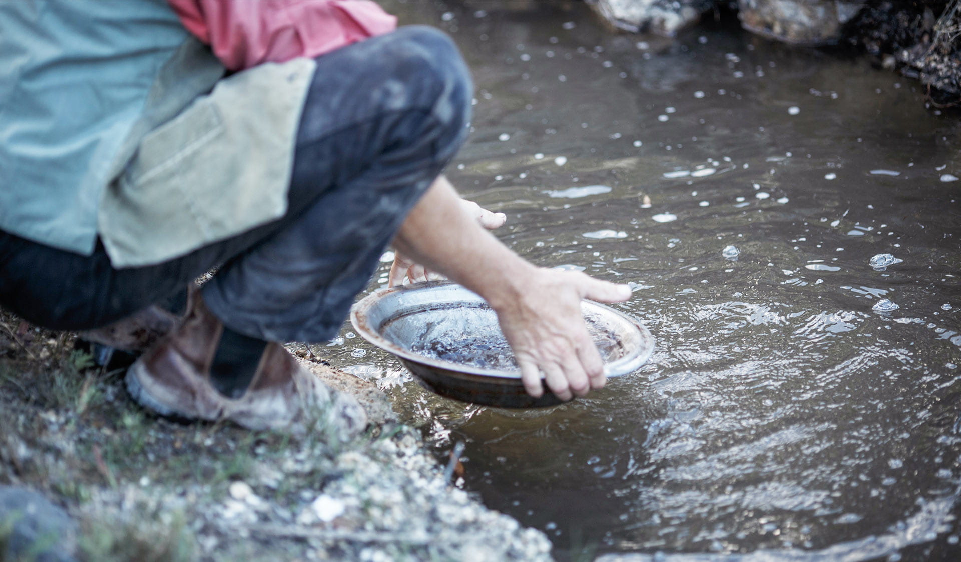
Gold Panning, Fossicking and Prospecting
Gold panning, fossicking and prospecting typically involves the use of metal detectors, hand tools, pans and sluices in the search for gold, gemstones and other minerals.
Prospecting can be an exciting experience that can be enjoyed alone or with a group, and there's no better place to do it than Victoria with many of the world’s largest gold nuggets have been found in the Golden Triangle of central Victoria.
Elsewhere, gemstone fossickers have found sapphires, zeolites, agate, and a whole host of other beautiful gems just waiting to be uncovered.
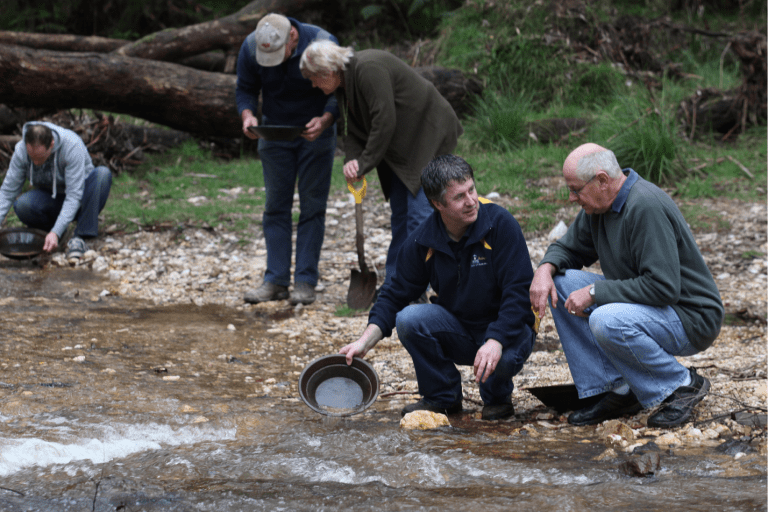
Find gold with a Licensed Tour Operator
Need to know
Fossicking and prospecting
Prospecting permits
A Miner's Right is a permit for prospecting in Victoria and must be carried at all times while you are prospecting. The only exception is if you are part of an organised group prospecting under the authority of a valid Tourist Fossicking Authority. The Mineral Resources Development Act 1990 sets out the rights and obligations of the holder of a Miner's Right.
Minimum impact prospecting
You can enjoy prospecting and help minimise any impact in the following ways:
- Prospect only in the permitted area.
- Only drive your vehicles on tracks and roads open to the public.
- Only park your vehicle on the roadside.
- Take all rubbish home or place it in a bin where provided. Do not bury it.
- Minimise any damage to vegetation including the ground layer.
- Restore the ground as you found it - backfill any holes you dig and replace any leaf litter as it was as soon as practicable.
Heritage Act 2017
Under the terms of the Heritage Act 2017 it is an offence to damage or disturb a place listed on the Victorian Heritage Register unless a Permit has been obtained from the Executive Director, Heritage Victoria (or a permit exemption applies).
You can view details of places included in the Heritage Register on the Victorian Heritage Database website.
The Heritage Act also provides protection for all historical archaeological sites in Victoria, including sites that are not recorded on any statutory registers or listings. It is an offence to disturb any archaeological site, or remove objects (artefacts) from a site.
Prospectors should be aware that the holding of a Victorian miner’s right allows them to prospect and fossick for gold, gemstones and other minerals in Victoria but does not confer any rights in relation to the requirements of the Heritage Act 2017. Read more about the protection of archaeological sites and objects in Victoria on the Heritage Victoria website.
Aboriginal cultural heritage
Aboriginal cultural heritage is the continuing record of Victoria's Aboriginal societies, who have existed in this land for tens of thousands of years. It is not just a remnant of history. It's alive, and constantly changing and evolving – often expressed through cultural traditions that have been reclaimed and revitalised in a contemporary setting.
Protecting Aboriginal cultural heritage is not just fundamental for Aboriginal peoples' identity and wellbeing. It's also an important part of Victoria's heritage as a whole – our shared story of how we have grown and evolved as a society. Parks Victoria is committed to protecting and preserving Aboriginal cultural heritage across the parks estate in Victoria.
All Aboriginal cultural heritage is protected under the Aboriginal Heritage Act 2006 (Vic.) (the Act). If you come across any Aboriginal cultural heritage, Section 24 of the Act requires that the discovery of Aboriginal cultural heritage places or objects be reported to the First Peoples – State Relations as soon as practicable. It is an offence under Section 27 of the Act, to harm Aboriginal cultural heritage and under Section 28 to do an act that harms or is likely to harm Aboriginal cultural heritage. See more information about First Peoples State Relations role and Aboriginal cultural heritage and you can find out more about reporting Aboriginal places or objects.
Parks where you can fossick and prospect
View the Change of Conditions park alerts from these parks before you visit:
Change of Conditions
Nature being nature, sometimes conditions can change at short notice. It’s a good idea to check this page ahead of your visit for any updates.
-
Castlemaine Diggings National Heritage Park
Loop track closed due to Phytophthora outbreak
Loop access will have limited vehicle access to reduced the risk of spread of phytophthora cinnamomi pathogen. -
Notices Affecting Multiple Parks
Night park closures for deer control work
Deer control works will be taking place in a number of locations within the Middle Yarra landscape. These include: Jumping Creek Reserve, Mt Lofty Reserve, Pound Bend Reserve, The Common (Warrandyte State Park), Kearneys, Pontville, Tikalara, Morrisons, Seawards, Longridge, Overbank/Gaybrooke Block, Glynns Reserve (Yarra Valley Parklands) and the Yanakie Block, One Tree Hill and Rifle Range Reserve (Warrandyte-Kinglake Nature Conservation Reserve) and the Biolink area of Kinglake National Park. The goal of this project is to reduce deer populations to mitigate deer impacts on the values in the surrounding area.This program will be conducted by professional contract shooters and will operate between the 13th of July 2026 and 30th June 2027 – excluding public holidays, school holidays and weekends. The program will be conducted in the areas highlighted on the attached map.The affected areas within the park/reserve will be closed between the hours of 4pm and 6am during nights of control. Signs will be displayed at all official entrance points to the park/reserve when shooting is in progress.If you have any questions regarding the program, call the Parks Victoria Information Centre on 13 1963.Attachments: Warrandyte SP deer control zones 26-27 (1) (660KB)
-
Beechworth Historic Park
Spring Creek Bridge Closed
Spring Creek Bridge is closed to all vehicles and pedestrians due to significant damage from storm and flood events.Pedestrian and bicycle access is permitted to either side of the bridge via Gorge Road, however there is currently no through access.More information is available within the attached 'Spring Creek Bridge Closure - Update for Beechworth Community'Attachments: Spring Creek Bridge Closure - Update for Beechworth Community #6 - October 2025 (538KB)
More to discover
Historic sites
Aboriginal heritage
Wildlife viewing